
Counties: Wayne Constructed 12 June 1964 | Length 1.709 km | |
 | ||
Existed: June 12, 1964 (1964-06-12) – present | ||
Interstate 375 (I-375) in Detroit, at only 1.062 miles (1.71 km) in length, once had the distinction of being the shortest signed Interstate Highway in the country. It is the southernmost leg of the Walter P. Chrysler Freeway and a spur of I-75 into downtown Detroit, ending at the unsigned Business Spur Interstate 375 (BS I-375), better known as Jefferson Avenue. The freeway opened on June 12, 1964. The Michigan Department of Transportation (MDOT) announced in 2013 that it may remove I-375 in the future.
Contents
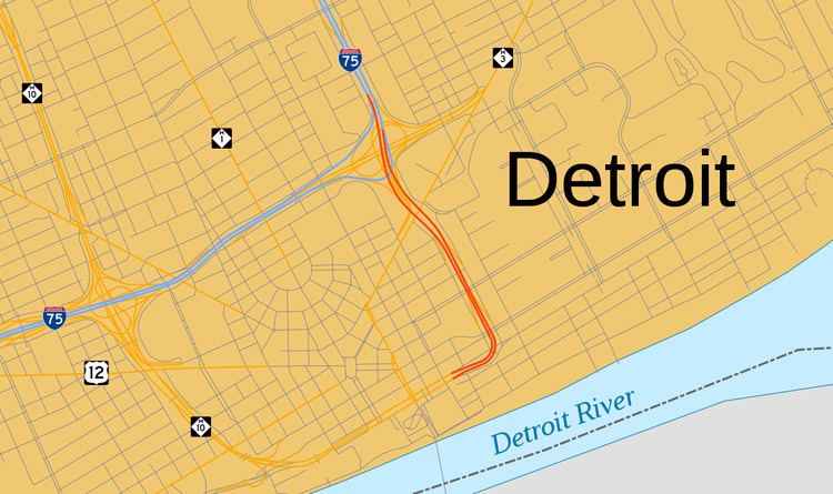
Map of I-375, Detroit, MI, USA
Route description
I-375 and the Chrysler Freeway begin at Jefferson Avenue and St. Antoine Street in downtown Detroit near the Renaissance Center. They run east before turning north. Just about a mile (1.6 km) after the southern terminus, I-375 meets the Fisher Freeway which carries I-75 north of downtown. At this interchange, I-75 takes ramps to leave the Fisher Freeway and use the Chrysler Freeway, replacing I-375. I-375 is a four-lane freeway the entire length. The entire length of I-375 is included on the National Highway System, a network of roadways that are important to the country's economy, defense, and mobility.
According to the Michigan Department of Transportation (MDOT), I-375 is 1.062 miles (1.709 km). At the time it opened until at least 2007, I-375 was the shortest signed Interstate in the country. Based on FHWA data, there are three Interstates that are shorter: I-110 in Texas (0.92 mi or 1.48 km), I-878 in New York (0.70 mi or 1.13 km) and I-315 in Montana (0.83 mi or 1.34 km). The latter two designations are not signed on their respective roadways, and I-110 in Texas has since been signed.
Every year, MDOT conducts a series of surveys on its highways in the state to measure traffic volume. In 2009, MDOT calculated that 14,112 vehicles per day used the southernmost section of I-375, on average, and 53,900 vehicles used the northernmost section near I-75. These vehicles included 798 trucks.
History
Construction on the first segments of the Chrysler Freeway started on January 30, 1959. The area where the freeway was built was called Black Bottom, a historic district that received its name from the soil found there by French explorers. In the 1940s and 1950s, the area was the home to a community of African-American entrepreneurs and businesses that rivaled Harlem in New York City. Black Bottom was one of the oldest neighborhoods in the city, and at the time of freeway construction, it had wooden sewers and dilapidated buildings. The area, like Corktown to the west of downtown, was targeted for urban renewal and infrastructure improvements in the 1950s and 1960s, which included the Chrysler Freeway and public housing projects.
On June 12, 1964, a surface street highway/freeway in Detroit was opened running north from Jefferson Avenue and Randolph Street to the Fisher/Chrysler freeway interchange. The southern most segment, built through the Black Bottom neighborhood, was designated I-375 at this time. The freeway cost $50 million to build (equivalent to $780 million in 2015).
In April 2013, MDOT announced that it was studying whether to repair the freeway at a cost of $80 million, or convert the freeway south of Gratiot Avenue into a boulevard to reduce maintenance cost, making the area around it more pedestrian-friendly, and thus attract development. Converting this segment to a boulevard would free up 12 acres (4.9 ha) of land for development which is currently used for the freeway and its right-of-way. The department invited businesses and other groups affected by the potential project to participate in the study in November 2013. Advocates of the conversion cite increased pedestrian access and an improved connection between Eastern Market and downtown as reasons to remove the freeway. Some people who live or work along the freeway and in the downtown area note the improved access I-375 provides to the area as reasons to retain the freeway.
Six alternative proposals for rebuilding I-375 were unveiled by MDOT in June 2014. They ranged in price from $40 million to $80 million. These options include rebuilding the freeway as is, reducing it to a boulevard or one-way streets, or upgrading the existing freeway right-of-way to include bike lanes and other pedestrian-friendly features. In January 2016, the department announced that any decision on a course of action would be delayed indefinitely.
Exit list
The entire highway is in Detroit, Wayne County. All exits are unnumbered.
Business spur
The unsigned Business Spur Interstate 375 (BS I-375), which is 0.167 miles (0.269 km) long, continues west on Jefferson Avenue from the southern end of I-375, ending at the entrance to the Detroit–Windsor Tunnel at Randolph Street (M-3). Jefferson Avenue past that intersection is M-10. BS I-375 runs next to the Renaissance Center and under a segment of the People Mover. This designation was created in 1964. The 2009 traffic surveys by MDOT reported that 33,376 vehicles, including 922 trucks, had used BS I-375.