
Intercommunality Brenne Val de Creuse Area 11.12 km² | Canton Le Blanc Population (2009) 334 Local time Monday 6:22 AM | |
 | ||
Weather 9°C, Wind N at 10 km/h, 91% Humidity | ||
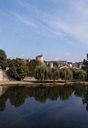
Ingrandes is a commune in the Indre department in central France. The village is the site of the Gallic city of Pictavorum during the era of the Roman Empire's domination of this part of Western Gaul (France).
Contents
Map of 36300 Ingrandes, France
Geography
The commune is located in the parc naturel régional de la Brenne.
The Salleron forms most of the commune's southeastern border, then flows into the Anglin. The village lies in the middle of the commune, on the right bank of the Anglin, which flows northwest through the commune.
References
Ingrandes, Indre Wikipedia(Text) CC BY-SA