
Basin area 471 km² Mouth elevation 0 | ||
 | ||
- right Calder River, Big Creek | ||
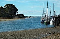
Storm day on the inglis river tasmania
The Inglis River is a river in North West Tasmania, Australia, it extends approximately 61 kilometres (38 mi) from the Campbell Ranges near Takone before discharging into Bass Strait at Wynyard. The Flowerdale River is the largest tributary system on the Inglis River and makes up approximately one-third of the 471 km2 Inglis-Flowerdale catchment basin.
Contents
- Storm day on the inglis river tasmania
- Map of Inglis River Tasmania Australia
- Inglis river
- Inglis Flowerdale catchment area
- Environment and wildlife
- Willow removal
- References
Map of Inglis River, Tasmania, Australia
Inglis river
Inglis-Flowerdale catchment area
While not tributaries of the main river system, Sisters Creek and Seabrook Creek are notable minor creeks which form part of the 616 km2 Inglis-Flowerdale catchment area. Annual rainfall ranges from about 1000 mm at the coast to greater than 1600 mm in the upper reaches of the catchment, some 26 km inland from Wynyard.
Forestry plantations dominate the landscape in the western region of the catchment, with intensive agriculture land-use in the north and eastern regions. Because of the steep and confining nature of the topography around the Inglis and Flowerdale rivers, both have retained substantial native forests that tend to buffer the rivers from both land-use activities.
Environment and wildlife
A 2003 water assessment report determined that the upper Inglis and Flowerdale Rivers and their tributaries are in generally good ecological health, however the middle and lower reaches of the Inglis River have less healthy macroinvertebrate communities. The poorer health of these communities suggest that they have been impacted by sedimentation from upstream forestry operations, gravel pits and poor stream-side agricultural land management practices. Measures to help mitigate further environment issues may include fencing off rivers to prevent livestock from accessing waterways and re-vegetation of river banks to prevent further erosion.
Beddomeia capensis is an endangered freshwater snail that had previously been surveyed at a tributary of Big Creek in 1989, but is now only known to occur on a few small streams upon Table Cape. Other aquatic threatened species in the Inglis-Flowerdale catchment includes the endangered giant freshwater crayfish, and the Australian grayling.
Willow removal
During 1999 and 2000, large scale willow infestation removal works were undertaken along the lower reaches of the Inglis River in the Flowerdale valley under the guidance of a Federal Government funding initiative. Poor remediation processes at the time, which involved removing the roots of the trees, has led to significant soil erosion and remains to be an issue for local agricultural landholders - more than a decade later.