
Population 5,503 (2011 census) Postal code 6052 | Postcode(s) 6052 Area 2.9 km² | |
 | ||
Location 5 km (3 mi) NE of Perth CBD | ||
Inglewood is a suburb of Perth, Western Australia in the local government area of the City of Stirling.
Contents
- Map of Inglewood WA 6052 Australia
- History
- Residential development
- Community development
- Significant landmarks
- Transport
- References
Map of Inglewood WA 6052, Australia
History
With a name thought to have been derived from the Norwegian barque Inglewood (its late nineteenth century voyage was mentioned in The West Australian on 24 May 1904), the suburb of Inglewood began when land was first granted to John Gregory in 1831. It is also plausible to derive that the suburb was named after the Inglewood Gold rush region of California given the suburb was developed during the gold boom era of the 1890s by a company calling itself 'Gold Estates of Australia'. E.W. Hammer named part of the estate "Inglewood Estate" in 1895.
Regarded as part of Maylands in the early years, Inglewood was initially developed by a company called Gold Estates of Australia and a section now referred to as The Avenues was the first to be subdivided. This development included land from the railway line to North Street and eventually through to Eleventh Avenue and Dundas Road; the later subdivision was named Inglewood Estate.
Residential development
Inglewood has experienced two distinct booms in residential growth: between 1904 and 1920 single residential housing was built to accommodate the blue-collar population while more development occurred around World War Two between 1935 and 1940.
The majority of residences in Inglewood are of pre-war vintage (many are of a Federation or Californian bungalow style) and towards Mount Lawley a typical lot size is 730m2, increasing to up to 1400m2 east of Beaufort Street.
Inglewood has a high heritage value with numerous places of cultural and historical significance and many of the older dwellings have been renovated and restored to their original styles. In addition to character housing, there are 1960s apartments and modern unit developments scattered throughout the suburb.
Community development
The main commercial area within Inglewood is centred on Beaufort Street and contains retail services, a library and a recreation centre and there are several small shops that cater for daily needs.
Inglewood contains many recreational facilities, including the Terry Tyzack Aquatic Centre, Mount Lawley Golf Course and Macaulay Park, and there are facilities to play tennis and soccer, as well as bocce. Inglewood Primary School meets the educational needs for younger students while the Home of Peace provides services for elderly residents.
Significant landmarks
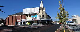
Significant landmarks include the prominent clock tower on the corner of Beaufort Street and Dundas Road, highly visible to northbound traffic along Beaufort Street, and the Inglewood Civic Centre, opened in 1991, incorporating the local library, an autumn centre and children’s centre. Inglewood Primary School, the major school for the area, is located just off Beaufort Street. The clock tower was originally part of a picture theatre - the Civic - and shopping complex designed, built, and owned by Tom Snooks (1890–1958) a local picture-show man and builder-developer from the 1910s to the 1940s. This heritage building complex has recently (2006–2008) been redeveloped for residential purposes.
Transport
The suburb is served by a number of Transperth bus routes operated by Path Transit. The 360, 361, 362 (Alexander Heights-Perth) and 950 (Mirrabooka-Perth-Curtin University) cover Alexander Drive. The 66, 67, 68, 950 and 16 buses pass through Inglewood along Walter Road and Beaufort Street.