
Country India | ||
 | ||
The Indian Rivers Inter-link is a proposed large-scale civil engineering project that aims to link Indian rivers by a network of reservoirs and canals and so reduce persistent floods in some parts and water shortages in other parts of India.
Contents
- History
- The need
- Plan
- Himalayan component
- Peninsular Component
- Intra state inter linking of rivers
- International comparisons
- Costs
- Ecological and environmental issues
- Displacement of people and fisheries profession
- Poverty and population issues
- International issues
- Political views
- Progress
- References
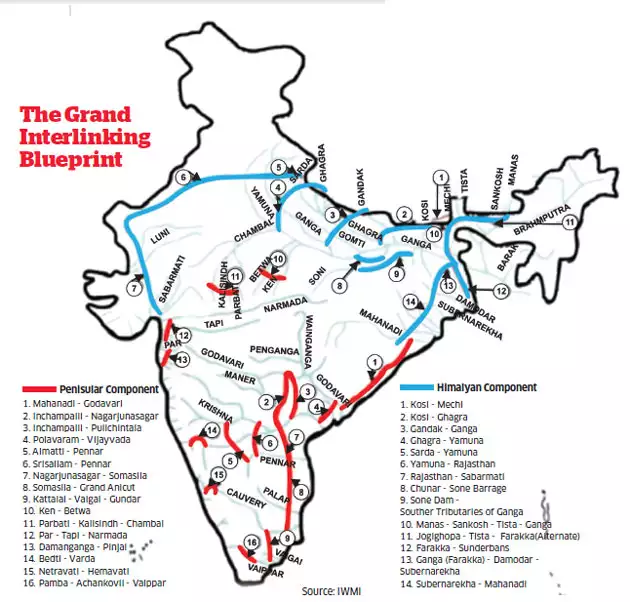
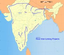
The Inter-link project has been split into three parts: a northern Himalayan rivers inter-link component, a southern Peninsular component and starting 2005, an intrastate rivers linking component. The project is being managed by India's National Water Development Agency (NWDA), under its Ministry of Water Resources. NWDA has studied and prepared reports on 14 inter-link projects for Himalayan component, 16 inter-link projects for Peninsular component and 37 intrastate river linking projects.
The average rainfall in India is about 4,000 billion cubic meters, but most of India's rainfall comes over a 4-month period – June through September. Furthermore, the rain across the very large nation is not uniform, the east and north gets most of the rain, while the west and south get less. India also sees years of excess monsoons and floods, followed by below average or late monsoons with droughts. This geographical and time variance in availability of natural water versus the year round demand for irrigation, drinking and industrial water creates a demand-supply gap, that has been worsening with India's rising population.
Proponents of the rivers inter-linking projects claim the answers to India's water problem is to conserve the abundant monsoon water bounty, store it in reservoirs, and deliver this water – using rivers inter-linking project – to areas and over times when water becomes scarce. Beyond water security, the project is also seen to offer potential benefits to transport infrastructure through navigation, as well as to broadening income sources in rural areas through fish farming. Opponents are concerned about knowledge gap on environmental, ecological, social displacement impacts as well as unseen and unknown risks associated with tinkering with nature. Others are concerned that some projects create international impact and the rights of nations such as Bangladesh must be respected and negotiated.

History
The Inter-linking of Rivers in India proposal has a long history. During the British colonial rule, for example, the 19th century engineer Arthur Cotton proposed the plan to interlink major Indian rivers in order to hasten import and export of goods from its colony in South Asia, as well as to address water shortages and droughts in southeastern India, now Andhra Pradesh and Orissa.
In the 1970s, Dr. K.L. Rao, a dams designer and former irrigation minister proposed "National Water Grid". He was concerned about the severe shortages of water in the South and repetitive flooding in the North every year. He suggested that the Brahmaputra and Ganga basins are water surplus areas, and central and south India as water deficit areas. He proposed that surplus water be diverted to areas of deficit. When Rao made the proposal, several inter-basin transfer projects had already been successfully implemented in India, and Rao suggested that the success be scaled up.
In 1980, India’s Ministry of Water Resources came out with a report entitled "National Perspectives for Water Resources Development". This report split the water development project in two parts – the Himalayan and Peninsular components. Congress Party came to power and it abandoned the plan. In 1982, India financed and set up a committee of nominated experts, through National Water Development Agency (NWDA) to complete detailed studies, surveys and investigations in respect of reservoirs, canals and all aspects of feasibility of inter-linking Peninsular rivers and related water resource management. NWDA has produced many reports over 30 years, from 1982 through 2013. However, the projects were not pursued.
The river inter-linking idea was revived in 1999, after a new political alliance formed the central government, but this time with a major strategic shift. The proposal was modified to intra-basin development as opposed to inter-basin water transfer.
By 2004, a different political alliance led by Congress Party was in power, and it resurrected its opposition to the project concept and plans. Social activists campaigned that the project may be disastrous in terms of cost, potential environmental and ecological damage, water table and unseen dangers inherent with tinkering with nature. The central government of India, from 2005 through 2013, instituted a number of committees, rejected a number of reports, and financed a series of feasibility and impact studies, each with changing environmental law and standards.
In February 2012, while disposing a Public Interest Litigation (PIL) lodged in the year 2002, Supreme Court (SC) refused to give any direction for implementation of Rivers Interlinking Project. SC stated that it involves policy decisions which are part of legislative competence of state and central governments. However, SC directed the Ministry of Water Resources to constitute an experts committee to pursue the matter with the governments as no party had pleaded against the implementation of Rivers Interlinking Project.
The need
India receives about 4,000 cubic kilometers of rain annually, or about 1 million gallons of fresh water per person every year. However, the precipitation pattern in India varies dramatically across distance and over calendar months. Much of the precipitation in India, about 85%, is received during summer months through monsoons in the Himalayan catchments of the Ganges-Brahmaputra-Meghna (GBM) basin. The northeastern region of the country receives heavy precipitation, in comparison with the northwestern, western and southern parts. The uncertainty of start date of monsoons, sometimes marked by prolonged dry spells and fluctuations in seasonal and annual rainfall is a serious problem for the country. The nation sees cycles of drought years and flood years, with large parts of west and south experiencing more deficits and large variations, resulting in immense hardship particularly the poorest farmers and rural populations. Lack of irrigation water regionally leads to crop failures and farmer suicides. Despite abundant rains during July–September, some regions in other seasons see shortages of drinking water. Some years, the problem temporarily becomes too much rainfall, and weeks of havoc from floods. This excess-scarcity regional disparity and flood-drought cycles have created the need for water resources management. Rivers inter-linking is one proposal to address that need.
Population increase in India is the other driver of need for river inter-linking. India's population growth rate has been falling, but still continues to increase by about 10 to 15 million people every year. The resulting demand for food must be satisfied with higher yields and better crop security, both of which require adequate irrigation of about 140 million hectares of land. Currently, just a fraction of that land is irrigated, and most irrigation relies on monsoon. River inter-linking is claimed to be a possible means of assured and better irrigation for more farmers, and thus better food security for a growing population. In a tropical country like India with high evapotranspiration, food security can be achieved with water security which in turn is achieved with energy security to pump water to uplands from water surplus lower elevation river points up to sea level.
When sufficient salt export is not taking place from a river basin to the sea in an attempt to harness the river water fully, it leads to river basin closer and the available water in downstream area of the river basin becomes saline and/ or alkaline water. Land irrigated with saline or alkaline water becomes gradually in to saline or alkali soils. The water percolation in alkali soils is very poor leading to waterlogging problems. Proliferation of alkali soils would compel the farmers to cultivate rice or grasses only as the soil productivity is poor with other crops and tree plantations. Cotton is the preferred crop in saline soils compared to many other crops. Interlinking water surplus rivers with water deficit rivers is needed for the long term sustainable productivity of the river basins and for mitigating the anthropogenic influences on the rivers by allowing adequate salt export to the sea in the form of environmental flows.
India needs infrastructure for logistics and movement of freight. Using connected rivers as navigation is a cleaner, low carbon footprint form of transport infrastructure, particularly for ores and food grains.
India currently stores only 30 days of rainfall, while developed nations strategically store 900 days worth of water demand in arid areas river basins and reservoirs. India’s dam reservoirs store only 200 cubic meters per person. India also relies excessively on groundwater, which accounts for over 50 percent of irrigated area with 20 million tube wells installed. About 15 percent of India’s food is being produced using rapidly depleting groundwater. The end of the era of massive expansion in groundwater use is going to demand greater reliance on surface water supply systems. Proponents of the project suggest India's water situation is already critical, and it needs sustainable development and management of surface water and groundwater usage.
Plan
The National perspective plan envisions about 150 million acre feet (MAF) (185 billion cubic metres) of water storage along with building inter-links. These storages and the interlinks will add nearly 170 million acre feet of water for beneficial uses in India, enabling irrigation over an additional area of 35 million hectares, generation of 40,000 MW capacity hydro power, flood control and other benefits.
The total surface water available to India is nearly 1440 million acre feet (1776 billion cubic meters) of which only 220 million acre feet was being used in the year 1979. The rest is neither utilized nor managed, and it causes disastrous floods year after year. Up to 1979, India had built over 600 storage dams with an aggregate capacity of 171 billion cubic meters. These small storages hardly enable a seventh of the water available in the country to be utilized beneficially to its fullest potential. From India-wide perspective, at least 946 billion cubic meters of water flow annually could be utilized in India, power generation capacity added and perennial inland navigation could be provided. Also some benefits of flood control would be achieved. The project claims that the development of the rivers of the sub-continent, each state of India, as well as its international neighbors stand to gain by way of additional irrigation, hydro power generation, navigation and flood control. The project may also contribute to food security to the anticipated population peak of India.
The Ganga-Brahmaputra-Meghna is a major international drainage basin which carries more than 1,000 million acre feet out of total 1440 million acre feet in India. Water is a scarce commodity and several basins such as Cauvery, Yamuna, Sutlej, Ravi and other smaller inter-State/intra-State rivers are short of water. 99 districts of the country are classified as drought prone, an area of about 40 million hectare is prone to recurring floods. The inter-link project is expected to help reduce the scale of this suffering and associated losses.
The National Perspective Plan comprised, starting 1980s, of two main components:
- Himalayan Rivers Development, and
- Peninsular Rivers Development
An intrastate component was added in 2005.
Himalayan component
Himalayan Rivers Development envisages construction of storage reservoirs on the main Ganga and the Brahmaputra and their principal tributaries in India and Nepal along with inter-linking canal system to transfer surplus flows of the eastern tributaries of the Ganga to the West apart from linking of the main Brahmaputra with the Ganga. Apart from providing irrigation to an additional area of about 22 million hectares the generation of about 30 million kilowatt of hydro-power, it will provide substantial flood control in the Ganga-Brahmaputra basin. The Scheme will benefit not only the States in the Ganga-Brahmaputra Basin, but also Nepal and Bangladesh, assuming river flow management treaties are successfully negotiated.
The Himalayan component would consist of a series of dams built along the Ganga and Brahmaputra rivers in India, Nepal and Bhutan for the purposes of storage. Canals would be built to transfer surplus water from the eastern tributaries of the Ganga to the west. This is expected to contribute to flood control measures in the Ganga and Brahmaputra river basins. It could also provide excess water for the Farakka Barrage to flush out the silt at the port of Kolkata.
By 2015, fourteen inter-links under consideration for Himalayan component are as follows, with feasibility study status identified:
Peninsular Component
This Scheme is divided in four major parts.
- Interlinking of Mahanadi-Godavari-Krishna-Pennar-Cauvery,
- Interlinking of West Flowing Rivers, North of Bombay and South of Tapi,
- Inter-linking of Ken with Chambal and
- Diversion of some water from West Flowing Rivers
This component will irrigate an additional 25 million hectares by surface waters, 10 million hectares by increased use of ground waters and generate hydro power, apart from benefits of improved flood control and regional navigation.
The main part of the project would send water from the eastern part of India to the south and west. The southern development project (Phase I) would consist of four main parts. First, the Mahanadi, Godavari. Krishna and Kaveri rivers would all be inter-linked by canals. Reservoirs and dams would be built along the course of these rivers. These would be used to transfer surplus water from the Mahanadi and Godavari rivers to the south of India. Under Phase II, some rivers that flow west to the north of Mumbai and the south of Tapi would be inter-linked. The water would supply additional drinking water needs of Mumbai and provide irrigation in the coastal areas of Maharashtra. In Phase 3, the Ken and Chambal rivers would be inter-linked to serve regional water needs of Madhya Pradesh and Uttar Pradesh. Over Phase 4, a number of west-flowing rivers in the Western Ghats, would be inter-linked for irrigation purposes to east flowing rivers such as Cauvery and Krishna.
The 800-km long Mahanadi-Godavari interlinking project would link River Sankosh originating from Bhutan to the Godavari in Andhra Pradesh through rivers like Teesta-Mahananda-Subarnarekha and Mahanadi.
The inter-links under consideration for Peninsular component are as follows, with respective status of feasibility studies:
Intra-state inter-linking of rivers
India approved and commissioned NDWA in June 2005 to identify and complete feasibility studies of intra-State projects that would inter-link rivers within that state. The Governments of Nagaland, Meghalaya, Kerala, Punjab, Delhi, Sikkim, Haryana, Union Territories of Puducherry, Andaman & Nicobar islands, Daman & Diu and Lakshadweep responded that they have no intrastate river connecting proposals. Govt. of Puducherry proposed Pennaiyar – Sankarabarani link (even though it is not an intrastate project). The States Government of Bihar proposed 6 inter-linking projects, Maharashtra 20 projects, Gujarat 1 project, Orissa 3 projects, Rajasthan 2 projects, Jharkhand 3 projects and Tamil Nadu proposed 1 inter-linking proposal between rivers inside their respective territories. Since 2005, NDWA completed feasibility studies on the projects, found 1 project infeasible, 20 projects as feasible, 1 project was withdrawn by Government of Maharashtra, and others are still under study.
International comparisons
The Indian Rivers Inter-link project is similar in scope and technical challenges as other major global river inter-link projects, such as:
- Rhine–Main–Danube Canal – completed in 1992, and also called the Europa Canal, it inter-links the Main river to the Danube river, thus connecting North Sea and Atlantic Ocean to the Black Sea. It provides a navigable artery between the Rhine delta at Rotterdam in the Netherlands to the Danube Delta in eastern Romania. It is 171 km long, has the summit altitude (between the Hilpoltstein and Bachhausen locks) is 406 m above sea level, the highest point on Earth reachable by ships from the sea. In 2010, the inter-link provided navigation for 5.2 million tonnes of goods, mostly food, agriculture, ores and fertilizers, reducing the need for 250,000 truck trips per year. The canal is also a source for irrigation, industrial water and power generation plants.
- Illinois Waterway system consists of 541 kilometers of interlink that connects a system of rivers, lakes, and canals to provide a shipping connection from the Great Lakes to the Gulf of Mexico via the Mississippi River. It provides a navigation route; primary cargoes are coal to powerplants, chemicals and petroleum upstream, and agriculture produce downstream primarily for export. The Illinois waterway is the principal source of industrial and municipal services water needs along its way; it serves the petroleum refining, pulp and paper processing, metal works, fermentation and distillation, and agricultural products industries.
- Tennessee–Tombigbee Waterway is a 377 kilometer man-made waterway that interlinks the Tennessee River to the Black Warrior-Tombigbee River in the United States. The Tennessee–Tombigbee Waterway links major coal producing regions to coal consuming regions, and serves as commercial navigation for coal and timber products. Industries that utilize these natural resources have found the Waterway to be their most cost-efficient mode of transportation. The water from the Tenn-Tom Waterway is a major source of industrial water supply, public drinking water supply, and irrigation along its way.
- Gulf Intracoastal Waterway, completed in 1949, interlinks 8 rivers, and is located along the Gulf Coast of the United States. It is a navigable inland waterway running approximately 1700 kilometers from Florida to Texas. It is the third busiest waterway in the United States, handling 70 million tonnes of cargo per year, and a major low cost, ecologically friendly and low carbon footprint way to import, export and transport raw materials and products for industrial, chemical and petrochemical industries in the United States. It has also become a significant source for fishing industry as well as for harvesting and shipping shellfish along the coast line of the United States.
Other completed rivers inter-linking projects include the Marne-Rhine Canal in France, the All-American Canal and California State Water Project in the United States, South–North Water Transfer Project in China, etc.
Costs
The rivers inter-linking feasibility reports completed by 2013, suggest the following investment needs and potential economic impact:
#The cost conversion in US $ is at latest conversion price on the historical cost estimates in Indian rupees
Ecological and environmental issues
Some activists and scholars have, between 2002 and 2008, questioned the merits of Indian rivers inter-link projects, and questioned if appropriate study of benefits and risks to environment and ecology has been completed so far. Bandyopadhyay et al. claim there are knowledge gaps between the claimed benefits and potential threats from environment and ecological impact. They also question whether the inter-linking project will deliver the benefits of flood control. Vaidyanathan claimed, in 2003, that there are uncertainty and unknowns about operations, how much water will be shifted and when, whether this may cause waterlogging, salinisation and the resulting desertification in the command areas of these projects. Other scholars have asked whether there are other technologies to address the cycle of droughts and flood havocs, with less uncertainties about potential environmental and ecological impact.
Displacement of people and fisheries profession
Water storage and distributed reservoirs are likely to displace people – a rehabilitation process that has attracted concern of sociologists and political groups. Further, the inter-link would create a path for aquatic ecosystems to migrate from one river to another, which in turn may affect the livelihoods of people who rely on fishery as their income. Lakra et al., in their 2011 study, claim large dams, interbasin transfers and water withdrawal from rivers is likely to have negative as well as positive impacts on freshwater aquatic ecosystem. As regards to the impact on fish and aquatic biodiversity, there could be positive as well as negative impacts.
Poverty and population issues
India has a growing population, and large impoverished rural population that relies on monsoon-irrigated agriculture. Weather uncertainties, and potential climate change induced weather volatilities, raise concerns of social stability and impact of floods and droughts on rural poverty. The population of India is expected to grow further at a decelerating pace and stabilize around 1.5 billion by 2050, or another 300 million people – the size of United States – compared to the 2011 census. This will increase demand for reliable sources of food and improved agriculture yields – both of which, claims India's National Council of Applied Economic Research, require significantly improve irrigation network than the current state. The average rainfall in India is about 4,000 billion cubic metre, of which annual surface water flow in India is estimated at 1,869 billion cubic metre. Of this, for topological and other reasons, only about 690 billion cubic metre of the available surface water can be utilised for irrigation, industrial, drinking and ground water replenishment purposes. In other words, about 1,100 billion cubic metre of water is available, on average, every year for irrigation in India. This amount of water is adequate for irrigating 140 million hectares. As of 2007, about 60% of this potential was realized through irrigation network or natural flow of Indian rivers, lakes and adoption of pumps to pull ground water for irrigation.
80% of the water India receives through its annual rains and surface water flow, happens over a 4-month period – June through September. This spatial and time variance in availability of natural water versus year round demand for irrigation, drinking and industrial water creates a demand-supply gap, that only worsens with India's rising population. Proponents claim the answers to India's water problem is to conserve the abundant monsoon water bounty, store it in reservoirs, and use this water in areas which have occasional inadequate rainfall, or are known to be drought-prone or in those times of the year when water supplies become scarce.
International issues
Misra et al. in their 2007 report, claim inter-linking of rivers initially appears to be a costly proposition in ecological, geological, hydrological and economical terms, in the long run the net benefits coming from it will far outweigh these costs or losses. However, they suggest that there is a lack of an international legal framework for the projects India is proposing. In at least some inter-link projects, neighboring countries such as Bangladesh may be affected, and international concerns for the project must be negotiated.
Political views
BJP-led NDA government of Atal Bihari Vajpayee had propagated the idea of interlinking of rivers to deal with the problem of drought and floods afflicting different parts of the country at the same time.
The Congress general secretary Rahul Gandhi said in 2009 that the entire idea of interlinking of rivers was dangerous and that he was opposed to interlinking of rivers as it would have "severe" environmental implications. BJP MP Rajiv Pratap Rudy suggested that Gandhi should do some research on the interlinking of rivers and its benefits and then arrive at a conclusion. Jairam Ramesh, a cabinet minister in former UPA government, said the idea of interlinking India's rivers was a "disaster", putting a question mark on the future of the ambitious project.
Karunanidhi, whose DMK has been a key ally of the Congress-led UPA at the Centre, wrote that linking rivers at the national level perhaps is the only permanent solution to the water scarcity problem in the country. Karunanidhi said the government should make an assessment of the project's feasibility starting with the south-bound rivers. DMK for 2014 general elections added Nationalisation and inter-linking of rivers to its manifesto.
Kalpasar Project is an irrigation project which envisages storing Narmada River water in an off-shore fresh water reservoir located in Gulf of Khambhat sea for further pumping to arid Sourashtra region for irrigation use. It is one of the preferred project for implementation by the Prime Minister of India, Narendra Modi.
Progress
On 16 September 2015, first linking was completed of rivers Krishna and Godavari. It is still under review.