
 | ||
Indian remote sensing
IRS System
Following the successful demonstration flights of Bhaskhar and Bhaskara-2 satellites launched in 1979 and 1981, respectively, India began to develop the indigenous Indian Remote Sensing (IRS) satellite program to support the national economy in the areas of agriculture, water resources, forestry and ecology, geology, water sheds, marine fisheries and coastal management.
Contents
- Indian remote sensing
- IRS System
- IRS data applications
- IRS launch log
- IRS Data Availability
- Capacity Building for IRS and Other Remote Sensing Data
- Future IRS launches
- Satellite data acquisition and processing
- References
Towards this end, India established the National Natural Resources Management System (NNRMS) for which the Department of Space (DOS) is the nodal agency, providing operational remote sensing data services. Data from the IRS satellites is received and disseminated by several countries all over the world. With the advent of high-resolution satellites new applications in the areas of urban sprawl, infrastructure planning and other large scale applications for mapping have been initiated.
The IRS system is the largest constellation of remote sensing satellites for civilian use in operation today in the world, with 11 operational satellites. All these are placed in polar Sun-synchronous orbit and provide data in a variety of spatial, spectral and temporal resolutions. Indian Remote Sensing Programme completed its 25 years of successful operations on March 17, 2013.
IRS data applications
Data from Indian Remote Sensing satellites are used for various applications of resources survey and management under the National Natural Resources Management System (NNRMS). Following is the list of those applications:
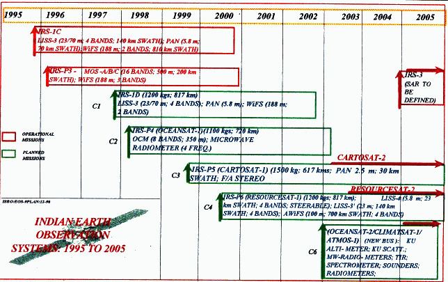
IRS launch log
The initial versions are composed of the 1 (A,B,C,D). The later versions are named based on their area of application including OceanSat, CartoSat, ResourceSat. Some of the satellites have alternate designations based on the launch number and vehicle (P series for PSLV).
IRS Data Availability
Data from IRS are available to its users through NRSC Data Centre and also through Bhuvan Geoportal of ISRO. NRSC data center provide data through its purchase process while Bhuvan Geoportal provides data in free and open domain.
Capacity Building for IRS and Other Remote Sensing Data
The capacity building programme of ISRO for IRS and other remote sensing applications is through Indian Institute of Remote Sensing (IIRS) Dehradun and Center of Space Science and Technology Education in Asia and the Pacific (CSSTEAP)(UN affiliated) Center located at Dehradun of Uttrakhand State in India.
Future IRS launches
Following are the remote sensing satellites planned by ISRO to be launched next strengthening the fleet of IRS satellites and widening their applications:
Satellite data acquisition and processing
The National Remote Sensing Centre (NRSC) at Hyderabad is the nodal agency for reception, archival, processing and dissemination of remote sensing data in the country. NRSC acquires and processes data from all Indian remote sensing satellites like Cartosat-1, Cartosat-2, Resourcesat-1, IRS-1D, Oceansat-1 and Technology Experiment Satellite as well as foreign satellites like Terra, NOAA and ERS.