
OS grid reference NS365915 Area rank 174= (Freshwater: 4) Area 70 ha | Highest elevation Tom na Clag 84 m Council area Argyll and Bute | |
 | ||
Gaelic name Innis Taigh a' Mhanaich Meaning of name island of the monk's house | ||
Inchtavannach (Scottish Gaelic: Innis Taigh a' Mhanaich; English: Island of the Monk's House), is one of the larger islands in Loch Lomond.
Contents
Map of Inchtavannach, United Kingdom
Geography
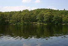
Inchtavannach faces the settlement of Aldochlay. Bandry Bay separates the island from the mainland, just south of Luss. According to Rev. Wilson, the island is "comparatively steep and lofty, mostly covered with natural oak". A northern summit, Tom nan Clag (English: Mound of the Bell), rises steeply to 282 feet (86 m), the highest point on the loch. A southern summit reaches 180 feet (55 m) in height.
History
It is thought that St Kessog was killed here.
It was once the site of a monastery, giving rise to its translated name of 'Monk's Isle'. A large house has stood on the site of the monastery since 1760. The island is predominantly wooded. It is here that the monks rang the bell to the call of prayer.
Roe Deer are recorded to have lived here. Sir James Colquhoun built a winding path up to the summit in the 17th century.
The poets Samuel Taylor Coleridge and William Wordsworth, together with Wordsworth's sister Dorothy, visited in August 1803.
The producer of Take the High Road Brian Mahoney lived in a house on the island for ten years.