
Width 70 m (230 ft) Population 0 Area 2 ha | Length 120 m (390 ft) Highest elevation 74 m (243 ft) Elevation 75 m Archipelago Izu Islands | |
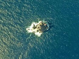 | ||
Inamba-jima (藺灘波島 or イナンバ島, Inanba-jima) is a volcanic, deserted island located in the Philippine Sea approximately 220 kilometres (140 mi) south of Tokyo and 35 kilometres (22 mi) southwest of Mikura-jima, in the center of the Izu archipelago, Japan.
Contents
Map of Inamba-jima
Geography
The island is an andesite pillar with sheer sides, the only visible portion of a submarine volcanic caldera. The above sea-level portion has a surface area of approximately 0.005 square kilometers, with a summit height of 74 metres (243 ft). Located in the Kuroshio Current, the area has abundant sea life, and is popular with sports fishermen and scuba divers.
References
Inamba-jima Wikipedia(Text) CC BY-SA