
Diameter 2.9×1.9 km Eponym Latin female name Ina | Depth 64 m | |
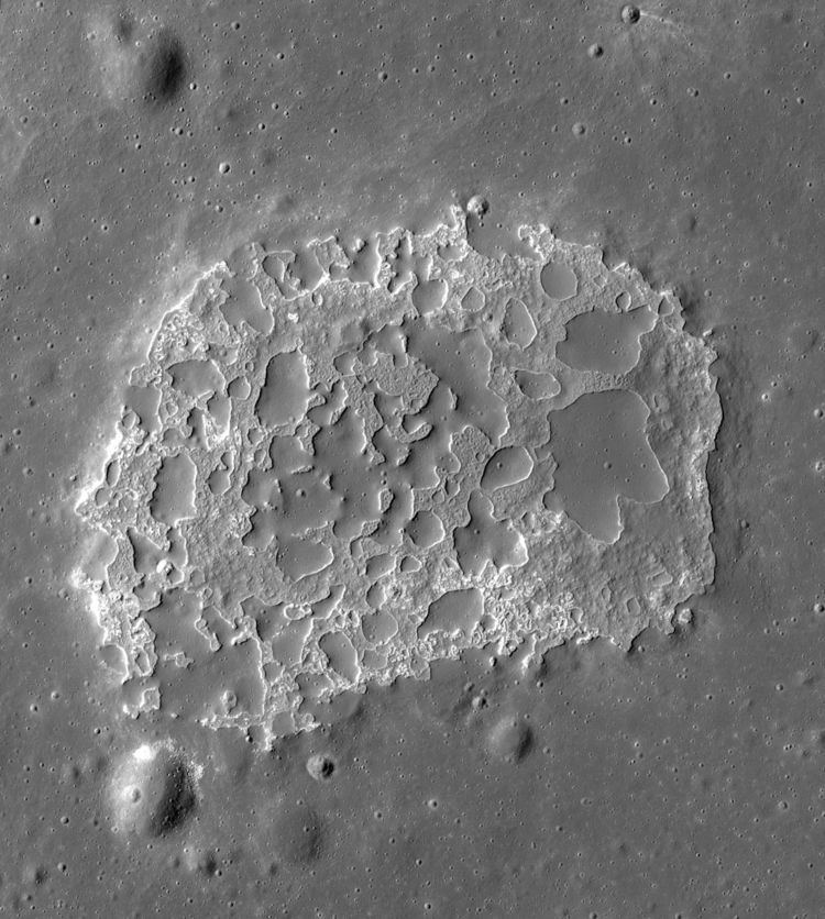 | ||
Ina is a peculiar small depression ("crater" in IAU nomenclature) on the Moon, in Lacus Felicitatis. It is D-shaped, 2.9×1.9 km wide and 64 m deep (from the deepest point of the bottom to the highest point of the rim).
Contents
Ina is remarkable for several dozens of low hills with flat or rounded tops and very sharp rounded boundaries, looking like drops of mercury. Their surface looks like usual surface of the Moon, and the space between them is strongly different. Ina is the most prominent of several dozens of similar features on the Moon. Their origin is unclear.
Discovery, exploration and naming
Ina was discovered on photographs taken in 1971 by the Apollo 15 crew from lunar orbit. It could have been found 5 years earlier, on images by Lunar Orbiter 4, but a photographic flaw prevented this. At the end of 1972 it was observed and photographed by the Apollo 17 crew. Later it was explored by orbiting spacecraft. Beginning in 2009, Lunar Reconnaissance Orbiter obtained photos of Ina with resolution of about 0.5 m/pixel and with varying illumination angles.
In 1974 on a topophotomap, published by NASA, this feature was given the Latin female name Ina, according to a tradition to give small lunar craters first human names. In 1979 this name was adopted by International Astronomical Union. The feature is also called D-caldera in Apollo-era publications due to its shape, and at the time it was believed to be a unique feature on the moon.
Two neighbouring features were named together with Ina in 1976. They are small craters Osama on its southwestern edge and Dag to the northwest (both 400 m in diameter). The widest hill in the eastern part of Ina (650 m wide) is named Mons Agnes (named in 1979).
Description
Ina is located on the top of rounded upland (dome) 300 m high and 15 km in diameter. It is situated on elongated plateau (horst) about 30 km wide. This plateau stands in the middle of Lacus Felicitatis ‒ a small lunar lake between Mare Serenitatis, Mare Vaporum and Mare Imbrium.
Ina is a D-shaped depression 2.9×1.9 km wide. It has an elevated rim 600–1000 wide and 30–40 m high. Eastern part of the rim is 10 m higher than western. Its outer slope is very gently sloping (1–3°) and lacks a distinct edge, but inner slope is very steep (tens of degrees) and has very sharp border with the depression. The deepest point of the depression is located somewhat to northwest from its center. This point is 30 m deeper than edges of the depression and 64 m deeper than the highest point of the rim.
There are 2 clearly distinct types of surface inside Ina: hills and lowlands. Surface of the hills looks like usual surface of Lacus Felicitatis, and surface of the lowlands is strongly different.
There are several dozens of the hills inside Ina. They have very diverse sizes and rounded amoeba-like edges, like drops of mercury. Many of them are connected with other hills or with edge of depression. They are rather low (5–25, usually 10–15 m). Their tops are flat or slightly rounded, but the slopes are very steep. Edges of the hills are usually very sharp. Often they are surrounded by a little moat. Boundary of the hills and lowland has the same appearance as the outer boundary of the depression. The surface of the hills is very smooth compared to the lowlands. In addition, although the sample size is not great, the hills do have an impact crater density intermediate between the fresh lowlands and the ancient neighboring plains of Lacus Felicitatis.
Ina lowlands are much more rough than hills, with lots of small irregular relief features, but their height is no more than several meters. Some craters are also discernible there. Somewhere the lowland contains small patches of very bright tone. They are outcrops of scattered rocks 1–5 m in size. Such patches are located mainly near the border of lowland and hills, especially in the lowest places.
Ina lowlands are bright bluish-grey. The hills are darker and brown (like the usual lunar surface). The lowlands resemble freshly exposed basalt with high titanium content, like the basalt seen in some young impact craters. Ina is surrounded by a weak dark halo. The surface of its surrounds is slightly more blue than the more distant surface.
Analogs
Ina is the most prominent, large and well-known representative of class of features called irregular mare patches, which are also known as "meniscus hollows" for similarity of their edges to a convex meniscus. Several dozens of such features are known on the Moon, all located in the maria. They are hypothesized to be volcanic in origin, but several hypotheses exist and their origin is far from certain. Somewhat similar, but distinct, features ("hollows") are rather common on Mercury. These features differ from lunar meniscus hollows by presence of bright halo; they are also more widespread, often bigger and usually located in impact craters.
Age
Surface of Ina lowlands seems to be much younger than the surface of the hills and outer surroundings. Evidence of this includes light color and low concentration of craters on these lowlands. The Moon surface darkens over time, and multiple meteorite impacts dot it with craters, blur sharp edges of all relief features and make slopes more gentle. Ina seems to be one of the youngest features on the Moon. The surface of the hills is much older: its age seems to be roughly equal to the age of usual surface of Lacus Felicitatis (more than 1 billion years), but the slopes and edges of these hills are young: they couldn't maintain their steepness and sharpness even for 50 million years. The dome, which hosts Ina, seems to be somewhat younger, than its surroundings, judging from crater concentration.
On the other hand, there is a lower estimation of age of the tops of Ina's hills: 33±2 million years (it is based on crater counts with the result of 137 craters/km2 for craters >10 m in diameter).
Origin
Ina's origin is unclear as of 2015. Firstly it was interpreted as a caldera of a very low ancient volcano. Another version considers it as a result of powerful ejection of some gases (volcanic or even radiogenic), which removed regolith. In that case the hills are places, where it preserved. The other hypothesis says that the hills are lava flows, inflated during growth under some dense coating. All these versions have flaws. In particular, Ina does not seem to have a ring of volcanic ejecta, and the volcanic activity on the Moon seems to be ceased a long time ago.
According to one another version, Ina appeared (and continues to form) due to collapsing of the regolith into some underground cavities. They can be ancient lava tubes or a result of evaporation of some volatile compounds. In that case the bright rocky places on Ina's floor are places, where the regolith has already fallen down, darker parts of lowlands are places of incomplete collapsing, and the hills are slowly diminishing remains of primigenial surface.