
Primary outflows Ganges River Surface elevation 5,004 m Length 2 km | Primary inflows Catchment area unknown Max. length 2,000 m (6,600 ft) Area 130 ha Mean depth 42 m Outflow location Ganges | |
 | ||
Similar Imja Glacier, Khumbu Glacier, Gokyo Lakes, Taboche, Gokyo Ri | ||
Imja Tsho (or Imja Lake) is a glacial lake created after melt water began collecting at the foot of the Imja Glacier on the lower part of the glacier in the 1950s. A 2009 study described this lake of melt water as one of the fastest-growing in the Himalaya. Held in place by a terminal moraine, Imja Tsho threatens downstream communities with the potential for a glacial outburst flood.
Map of Imja Lake, Khumjung 56000, Nepal
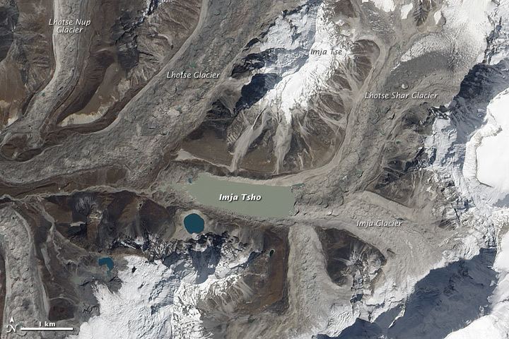
Imja Tsho has been identified as one of the potentially dangerous lakes in Himalaya. It is located at 27° 59' 17" N latitude, 86° 55' 31" E longitude and at an altitude of 5010 m in Everest region of Nepal. The catchment of Imja Tsho occupies the northeastern part of the Dudh Koshi sub-basin. The lake itself is located on the lower part of the glacier at the toe of its mother glaciers (snout of Imja and Lhotse Shar Glaciers). The Lhotse Shar Glacier flows in a south-westerly direction. The Imja Glacier on the other hand is oriented in a north-westerly direction and has its terminus at about 5100 m. These two glaciers coalesce approximately 3.5 km above the terminus and flow westwards just beneath the trekking path of Imja Tse.
The lake was first mapped in the form of a few ponds from the satellite image taken in 1962. The total area of the ponds was approximately 0.03 km2 then (27916 sq m). With the melting of glaciers, the ponds merged into a supra-glacial lake in the 1970s and it has grown continuously ever since. The lake area increased to approximately 0.8 km2 (796600 sq m) in 2000 with an average growth rate of 0.02 km2 per year. On the basis of newly released image of 21 November 2009 on Google Earth, the Imja Tsho has attained an area of 1.055 km2 as a result of which the growth rate of the lake has increased to 0.025 km2 per year from 2000 to 2009. The preliminary analysis has also shown that there has been an increase of almost 11% in the lake area compared to the area calculated on the basis of satellite image received on October 2008.
In 2016 the Nepalese Army constructed an outlet and drained over 4 million cubic meters of water from the lake.