
Elevation 5,357 m | ||
 | ||
Similar Kala Patthar, Ama Dablam, Imja Tse, Nuptse, Lhotse | ||
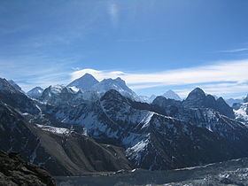
Gokyo Ri, aka Gokyo Peak (5,357 m, 17,575 ft above sea level), is a peak in the Khumbu region of the Nepal Himalayas. It is located on the west side of the Ngozumpa glacier, which is the largest glacier in Nepal and reputed to be the largest in the whole Himalayas. Gokyo (4,750 m, 15,583 ft above sea level), at the base of Gokyo Ri, is a small hamlet of a few stone houses and one of the highest settlements in the world. From Gokyo Ri it is possible to see four 8,000-metre peaks: Mount Everest, Lhotse, Makalu, and Cho Oyu. The Gokyo Lakes are in the area.
Map of Gokyo Ri, Khumjung 56000, Nepal
The Gokyo trek is a fairly popular trekking route. The route itself ends at Gokyo Ri, and trekkers typically turn around at this point and retrace their steps back to the trailhead. There is an alternative mountaineering route that begins near the southern tip of Ngozumpa Glacier and just south of Taujun Lake. This alternative route leads east over the Cho La, a pass at 5,420 m (17,782 ft), where it meets with the main Everest Base Camp trek.
There is another higher summit just north of where the main Gokyo trek route ends. It stands at an altitude of 5,483 m (17,989 ft) above sea level.