
 | ||
Rivers of the world honors iloilo river protection philippines
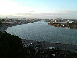
The Iloilo River located in the Province of Iloilo, Philippines is actually an estuary.
Contents
- Rivers of the world honors iloilo river protection philippines
- Map of Iloilo River Iloilo Philippines
- Iloilo river development project iloilo city
- Wharf
- Port
- Esplanade
- Bridges
- References
Map of Iloilo River, Iloilo, Philippines
The river starts in Oton at Batiano River, which is also an estuary, then traverses the Iloilo City districts of Lapuz, Lapaz, Mandurriao, Molo, Arevalo and the city proper, before emptying into the Iloilo Strait.
Iloilo river development project iloilo city
Wharf
Iloilo River wharf, including Muelle Loney in the Iloilo City Proper, is a natural harbor which made it a preferred port of call for ships seeking protection from strong winds and tropical monsoons. It serves as port for inter island ferries that travel from Iloilo City to Bacolod on Negros and to Guimaras. It is also drop-off point for fishing vessels that bring in their catch from the sea to be delivered to markets all over Iloilo.
Port
The Port of Iloilo was opened for international trade on 1855 and the coming of British Vice-consul Nicholas Loney, a year later, that led to the fast development of sugar industry in the region.
Esplanade
The Iloilo River Esplanade in Mandurriao district is a park development in one of its river banks constructed as a recreation area and an attraction for visitors.
Bridges
The bridges that cross the river include, into City Proper the Quirino-Lopez Bridge (built 1967, rehabilitated 2000) going to Lapuz district and Forbes (1910, rehabilitated 1975), Jalandoni and Drilon bridges going to La Paz district; and Diversion Bridge (1982) and Carpenters Bridge (2010, replacing a now-pedestrian only bridge) between Mandurriao and Molo districts.