
Existed: 1924 – present Counties: Schuyler Constructed 1924 | Length 14.77 km | |
 | ||
East end: US 67 / IL 100 in Frederick | ||
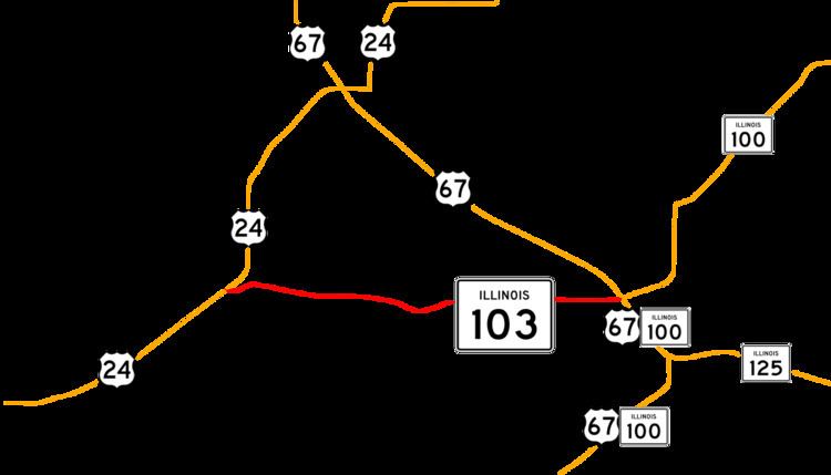
Illinois Route 103 is a 9.18-mile (14.77 km) state route in west-central Illinois, United States. The route, entirely in Schuyler County, runs from U.S. Route 24 near Ripley east to the intersection of U.S. Route 67 and Illinois Route 100 across the Illinois River from Beardstown. In addition to connecting Ripley and Beardstown, Route 103 also serves the community of Sugar Grove. The highway is part of both the National Highway System and the Lincoln Heritage Trail. Route 103 is maintained by the Illinois Department of Transportation. The route was established in 1924 between Ripley and its current eastern terminus; its western terminus was moved north to its current location in 1932.
Contents
Map of IL-103, Illinois, USA
Route description
Route 103 begins at a junction with U.S. Route 24 in Woodstock Township in southern Schuyler County, northeast of Ripley. The route initially runs eastward along the LaMoine River, passing through a forested area. After the river turns southward, the highway continues east through farmland. Route 103 intersects County Route 9 before entering the unincorporated community of Sugar Grove, where it meets County Route 1. After passing through Sugar Grove, the highway enters Bainbridge Township. The road makes a small southward dip through a tree-lined area, passing a small group of buildings and crossing a creek, before returning to its eastward trajectory. The route passes to the north of the community of Cottonwood. Route 103 runs through open farmland at the eastern end of its route, crossing two creeks and passing several farm buildings. The highway terminates at a junction with U.S. Route 67 and Illinois Route 100, across the Illinois River from Beardstown.
Route 103 is an undivided two-lane road for its entire length. The entire route is part of the National Highway System, a network of roads deemed significant to the nation's economy, defense, and mobility. Route 103 is also part of the Lincoln Heritage Trail, a series of highways connecting places with historic connections to Abraham Lincoln. According to the Illinois Department of Transportation, the annual average daily traffic on Route 103 in 2009 ranged from 1300 vehicles near the western terminus to 1400 near Sugar Grove; 200 to 225 of those vehicles were trucks.
History
Route 103 was designated in 1924 between Ripley and Beardstown. A road between Ripley and the route's current eastern terminus was first marked on state highway maps in 1924; this route began at Ripley and ran parallel to and south of the current route on its western half, before turning north and following the current alignment east at Layton. Route 103 was first numbered on the 1929 Illinois highway map. The western terminus of Route 103 was moved from Ripley to its current location in 1932, and the western half of the highway moved northward to its present alignment. The community of Layton, which was near the present location of Sugar Grove, was marked along the route until 1951.
Major intersections
The entire route is in Schuyler County.