
Area code(s) +387 33 | Time zone CET (UTC+1) Local time Friday 11:32 PM | |
 | ||
Weather 4°C, Wind NW at 6 km/h, 93% Humidity Colleges and Universities International University of Sarajevo, International Burch University, Sarajevo School of Science a | ||
Ilidža (Cyrillic: Илиџа, [i.lǐ.dʒa]) is a municipality of Sarajevo Canton in central Bosnia and Herzegovina. It has a metro population of 157,654 and is a chief suburb of Sarajevo and de facto its neighborhood . It is famous for the natural beauty of its surroundings and historical tradition dating back to neolithic times. Sarajevo International Airport is located nearby, as is the famous Vrelo Bosne spring.
Contents
- Map of IlidC5BEa Bosnia and Herzegovina
- Geography
- Climate
- History
- 1971
- 1991
- Current
- Government
- Economy
- Tourism
- References
Map of Ilid%C5%BEa, Bosnia and Herzegovina
Geography
Ilidža is known to have a pleasant and attractive geography. The city itself is built on fairly level ground, although it is surrounded by mountains. The biggest and most famous is mount Igman, whose 1,502 m (4,928 ft) peak towers above the city. On the mountain grows the Lillium Bosniacum, a branch of the Lily family of flowers that is a historical symbol of Bosnia. The area is rich in flint especially in the Butmir neighborhood.
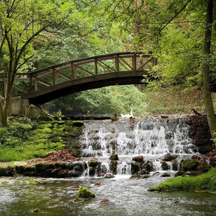
The Željeznica river, a tributary of the Bosna, passes through the town's center. The Bosna itself passes through Ilidža's outskirts. Its spring, Vrelo Bosne, is found a few kilometers to the west of town center and is a popular national park. A number of smaller streams also pass through the city's area.
A number of horticulture projects have been undertaken in the history of Ilidža. The city is today very rich in trees. The total area of the city's parks is about 50% of that of Sarajevo, which has six times its population. In 1894, an article in a London newspaper called Ilidža "One of the most beautiful places in the world".
Climate
Climate in this area has mild differences between highs and lows, and there is adequate rainfall year-round. The Köppen Climate Classification subtype for this climate is "Cfb" (Marine West Coast Climate/Oceanic climate).
History
Ilidža is one of the longest continuously inhabited regions in Bosnia and Herzegovina. Since the 19th century, numerous archeological finds have been made in the Butmir area, dating from Neolithic times. The so-called Butmir culture, is one of the best documented Neolithic cultures in Europe of the 26th and 25th centuries BC.
During Roman times, the Ilidža area was the location of the town known as Aquae Sulphurae. This was a Roman colony, and the largest settlement in the whole of Bosnia and Herzegovina at the time. Today numerous traces of Roman civilisation have been found, such as mosaics, ceramics, jewelry, coins, and even structural remains.
During the medieval period, the Ilidža area was part of the Bosnian province of Vrhbosna. Katera, one of the two original Bosnian towns mentioned by Constantine Porphyrogenitus in De Administrando Imperio, was found on the ground of today's Ilidža municipality. The disciples of Saint Cyril and Saint Methodius considered the area important enough to stop at Vrelo Bosne and build a church in the area.
The modern town of Ilidža as we know it was founded during the Ottoman rule of Bosnia. Its name derives from the Turkish word Ilıca, meaning "warm thermal springs". (Ilıca is also the name of a district of Erzurum, a southeast city of Turkey. There are also Ilıca-named municipalities in the following provinces of Turkey: Samsun, Kahramanmaraş, Antalya, Malatya, Ordu.) Numerous elements of Turkish culture found their way into Ilidža, such as a number of oriental homes from the 15th and 16th centuries that have survived to this day. Numerous mosques and bridges were also built at this time.
Ilidža, like the rest of Bosnia, experienced industrialisation and westernisation with the coming of Austria-Hungary. A railway station and tracks, hotels, and various other structures made Ilidža the most important town after Sarajevo in the region. This continued into the 1900s as Ilidža continued to grow and develop.
Before 1990, Ilidža was populated mainly by Serbs 47,21% and Bosniaks 31,58% . When war started in 1992 until the 1995 Dayton Peace Accord the municipality was divided between Bosnian Muslims (Hrasnica, Sokolovic Kolonija, Butmir) and Serb (Ilidža, Kotorac, Vojokovici, Grlica) parts. When, under the terms of the Accord, Ilidža was placed within the territory of the Bosnian Federation, the vast majority of Serbs fled the city to live in the Republika Srpska, destroying some buildings as they did so. In the process NATO and EU observers reported about violence between those Serbs who decided to leave and ones who wanted to stay, as those who were leaving looted and set on fire not just their but also houses and property of those who were staying as well. From 1996, Ilidža was home to the headquarters of the NATO peacekeeping force IFOR (later SFOR and EUFOR) before its move to nearby Butmir in the year 2000. During this period, the hotels Terme, Srbija (Serbia), Bosna (Bosnia) and Jadran were barricaded and the area used as NATO HQ. Today Ilidža remains a bustling, largely Bosniak-dominated town. Vojkovici and Grlica formed Eastern Ilidza Municipality which is dominated by Serbs.
1971
39,452 total
1991
According to the Yugoslav census of 1991, Ilidža had a pre-war population of 67,197. Of these, 28,836 were Bosniaks (43%), 24,982 were Serbs (37.2%), 6,901 were Croats (10.2%), and 5,126 identified themselves as Yugoslavs (7.6%), while 1,352 were classified as others (2%).
Current
The Ilidža Municipality consists of the core of the city of Ilidža, as well as the outlying small neighborhoods (by size Hrasnica, Sokolović Kolonija, Butmir, Kotorac), which although somewhat separated from the city center are still considered part of the city.
According to Sarajevo Canton statistics, the municipality of Ilidža has a total population of 47,654. According to Ilidža Municipality statistics, the population is slightly smaller, at about 44,454. Either way it is safe to assume that Ilidža has a population of about 46,000, give or take 1,500. Since the Sarajevo Canton statistics are far more detailed, and perhaps more recent, Wikipedia will take the 47,654 number as the official population.
Of these 47,654 residents, around 90% are Bosniaks, 7% Serbs and 3% Croats. Ilidža population accounts for a little under 12% of the population of Sarajevo Canton, and 2.1% of the Federation of Bosnia and Herzegovina.
In 2005, 84% of population of the municipality were ethnic Bosniaks.
Ilidžas population density is 332.3 inhabitants per km², which is incredibly low compared to the city of Sarajevo where the population density is 2470.1 inhabitants per km². This is largely due to the layout of Ilidža, described in the first paragraph above. Ilidžas population growth rate is 3.19%. If this rate continues, Ilidža should surpass the 100,000 mark in less than 25 years.
Government
Ilidža is widely considered a unique city, but is also thought of as an almost fully incorporated suburb of Sarajevo. As far as its own government goes, cities in Bosnia and Herzegovina typically do not have a normal "city government". Instead, the municipalities (Such as Ilidža Municipality) are based on major settlements and their surroundings. Thus the Ilidža Municipality government is the de facto government of Ilidža.
Municipality assembly: Party of Democratic Action 7 members, Social Democratic Party of Bosnia and Herzegovina 5 members, Union for a Better Future of BiH 2 members, Progressive Democratic Party (Bosnia and Herzegovina) 2 members, Social Democratic Union (Bosnia and Herzegovina) and Liberal Democratic Party (Bosnia and Herzegovina) 1 member, Our Party (Bosnia and Herzegovina) 1 member, People's Party for Work and Betterment 1 member, Independent 6 members
Economy
Prior to the war, Ilidža municipality was one of the five strongest in Bosnia and Herzegovina, and one of the ten strongest in the whole of Yugoslavia. The war had a devastating effect on the city's economy, but today it is slowly starting to recover. Several important local companies are based in Ilidža. The city's economy is based on food processing, electronics, and manufacturing.
One of the most important parts of Ilidža economy is its tourism. The natural beauty of the area is used to the city's advantage, attracting many tourists from both abroad and as near as neighboring Sarajevo. There are plans for future development to enhance tourism, including hotels and a cable railway line to Mt. Igman.
Tourism
Sarajevo International Airport is located just a few kilometers from the city. The region's natural beauty and historical sites are draws for tourists. Igman mountain is a popular destination for skiing and hiking, and Vrelo Bosne is one of the country's most popular parks. The Rimski Most ("Roman Bridge") over the Bosna river was built in the 16th century using actual Roman stones. Ilidža is popular among Arab tourists, with many services advertised in Arabic.