
Coat of arms Flag Federal subject Krasnoyarsk Krai District town Igarka Number of airports 1 | Country Russia Administrative district Turukhansky District Local time Friday 9:25 PM | |
 | ||
Administrative center of District town of Igarka Weather -14°C, Wind SE at 6 km/h, 91% Humidity | ||
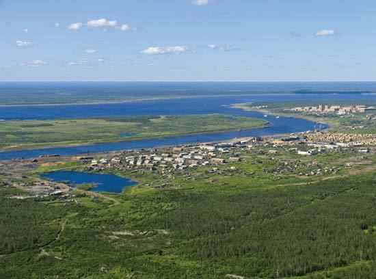
Igarka (Russian: Ига́рка) is a town in Turukhansky District of Krasnoyarsk Krai, Russia, located 163 kilometers (101 mi) north of the Arctic Circle. Population: 6,183 (2010 Census); 8,627 (2002 Census); 18,820 (1989 Census); 16,000 (1970).
Contents
- Map of Igarka Krasnoyarsk Krai Russia
- History
- Demographics
- Administrative and municipal status
- Transportation
- Culture
- References
Map of Igarka, Krasnoyarsk Krai, Russia
History
Igarka was founded in 1929 as a sawmill and a timber-exporting port. It was granted town status in 1931. From 1949 to 1953, the Salekhard–Igarka Railway project made an unsuccessful attempt to connect Igarka to the Russian railway network at Salekhard, claiming the lives of thousands of Gulag prisoners. During the deportations of 1948-1951 thousands of civilians were deported to Igarka from newly occupied territories of USSR. In that period some 5000-10000 Lithuanians alone were forcefully moved here from their homeland. About 1000 of them died there from cold and poor conditions in just the winter of 1948-1949.
Demographics
Population: 6,183 (2010 Census);[3] 8,627 (2002 Census);[5] 18,820 (1989 Census);[6] 16,000 (1970).
Before the collapse of the Soviet Union, the town was predominantly made up of Lithuanians, Germans, Russians, Tatars and Poles. When the Soviet Union fell apart many of these peoples moved back to their respective countries, turning the entire area into an entirely Slavic one populated by Russians, Ukrainians and Belorussians.
Administrative and municipal status
Within the framework of administrative divisions, it is incorporated within Turukhansky District as the district town of Igarka. As a municipal division, the district town of Igarka is incorporated within Turukhansky Municipal District as Igarka Urban Settlement.
Transportation
The town is a port on the Yenisei River and is located 673 kilometers (418 mi) away from the river's mouth.
It is served by the Igarka Airport whose location across the river makes access difficult when the water is partly thawed: in winter one can drive across, and in summer there is a boat connection but in between those seasons crossing is difficult.
Culture
The town's main attraction is a curious permafrost museum which has won some pan-European prizes.