
Country Angola Area 3,819 km² | Time zone WAT (UTC+1) Local time Friday 6:57 AM | |
 | ||
Province Luanda => Luanda Province Weather 26°C, Wind SE at 5 km/h, 86% Humidity | ||
Icolo e Bengo (English: Icolo and Bengo) is a city council (município or municipality) in the province of Luanda in Angola, as per decree 29/11, of 1 September 2011, which moved this municipality, along with the municipality of Quiçama from Bengo Province to Luanda Province.
Contents
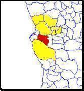
Map of Icolo e Bengo, Angola
The others being, Luanda, Belas, Cazenga, Cacuaco, Viana and Quiçama. The transfer documents were signed on 2 April 2012 in Catete by the governors of Luanda Province, Bento Bento, and João Miranda, of Bengo Province, in the presence of the minister for territorial administration, Bornito de Sousa.
It covers an area of 3,819 square kilometres (1,475 sq mi) and its estimated population as of 2006 is 58,830 inhabitants.
Icolo e Bengo is bordered to the north and south respectively by the municipalities of Dande and Quiçama (in Bengo and Luanda provinces respectively), to the east by the municipality of Cambambe (Cuanza Norte province), and to the west by the municipalities of Viana and Cacuaco (both in Luanda province).
Administrative Division
The municipality, with the seat in Catete, is divided into five comunas (communes), as follows: