
Native name 揖斐川 Length 121 km Basin area 1,840 km² | Basin size 1,840 km (710 sq mi) Discharge 84.28 m³/s Country Japan | |
 | ||
Main source Mount Kanmuri1,257 m (4,124 ft) | ||
The Ibi River (揖斐川, Ibi-gawa) is a tributary of the Kiso River located in Gifu and Mie Prefectures in Japan. Along with the Nagara and Kiso rivers, the Ibi is the third of the Kiso Three Rivers of the Nōbi Plain. It is one of Japan's first-class rivers. The former Tōkaidō post station of Kuwana-juku was located on the western banks of this river during the Edo period.
Contents
Map of Ibi River, Japan
GeographyEdit
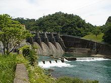
The Ibi River has its source in Mount Kanmuri, which is located in the town of Ibigawa in Gifu Prefecture, and from there flows south. During its course, it temporarily merges with the Kiso and Nagara Rivers. In the city of Kuwana, Mie Prefecture, it finally joins with the Nagara River for good and continues flowing until Ise Bay.
Gifu PrefectureEdit
Anpachi, Gōdo, Ibigawa, Ikeda, Kaizu, Mizunami, Ōno, Ōgaki, Wanouchi, Yōrō