
- land 0.06 sq mi (0 km) - summer (DST) CDT (UTC-5) Area code 504 | - water 0.00 sq mi (0 km), 0% Area 16 ha | |
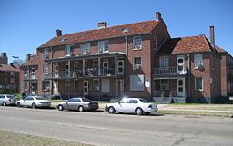 | ||
Iberville Projects was a neighborhood in the city of New Orleans and one of the low-income Housing Projects of New Orleans. Its boundaries were St. Louis Street to the north, Basin Street to the east, Iberville Street to the south and North Claiborne Avenue to the west. It is located in the 4th Ward of downtown New Orleans, on the former site of the Storyville district. The area is currently being redeveloped.
Contents
- Map of Iberville New Orleans LA 70112 USA
- Iberville projects new orleans avi
- Geography
- Crime
- 20th century
- 21st century
- Demographics
- Adjacent neighborhoods
- References
Map of Iberville, New Orleans, LA 70112, USA
Iberville projects new orleans avi
Geography
The Iberville Projects were located at 29°57′34″N 90°04′25″W and has an elevation of 0 feet (0 m) (mean sea level). According to the United States Census Bureau, the district has a total area of 0.06 square miles (0.2 km2), all of which is land.
The City Planning Commission defines the boundaries of Iberville Projects as these streets: St. Louis Street, Basin Street, Iberville Street and North Claiborne Avenue.
Crime
The Iberville Projects was known for its brutal crime. Trial is underway for a duo charged in Iberville killing. Alfred "Al" Dixon and Demonte "D-man" Carmouche are facing charges of second degree murder for the killing of Terrence Lewis. On July 8, 2012, Terrence Lewis was found shot to death in the 1400 block of Bienville Street. Lewis was targeted because of an ongoing beef with the men and the fact his cousin had been jailed for the murder of Alfred Dixon's brother. In November 2011, Alford Dixon was found shot to death. He was said to be a member of the 4th ward Goonies, a gang that operated throughout the Iberville Projects.
On the night of the shooting, Lewis went to his grandmother's house to search for an identification card he had lost. He was leaving to go to a nightclub but never made it past the porch. Dixon and Carmouche were waiting. Both were armed with semi automatic handguns. Once the teenagers opened fire, Lewis turned his back to run back into the house but a bullet ripped through his back. The shooters fled the scene and Lewis's grandmother ran outside to find her grandson slumped on the ground. He succumbed to his injuries at the hospital.
There were no eye witnesses to the slaying, but Dixon and Carmouche were identified from grainy surveillance footage. A couple of weeks later, police arrested Dixon and Carmouche in the murder after a stolen gun thought to have been used in the shooting was linked to one of the teens. Their defense attorney says "If you evaluate all of the evidence that they present... it doesn't really line up with the theory that the state is presenting to you".
20th century
The Iberville development was built on a ten block site in the early 1940s as part of the Wagner Bill. The land was previously Storyville, the city's official red light district. In 1940, the city declared 95% of the structures in Storyville substandard, clearing the way for construction of the project. There are 858 units in the Iberville.
During segregation, the Iberville was occupied by whites, while the nearby Lafitte Projects served the black tenants.
21st century
While the Iberville was closed following Hurricane Katrina, the project was one of the first to reopen. There was no significant damage.
New Orleans mayor Ray Nagin expressed a desire to redevelop the Iberville Projects as early as 2003. In May 2009, Nagin announced a HANO proposal to raze part of it for redevelopment into mixed-income housing. In 2011, HANO and the city of New Orleans was granted $30.5 million as part of the U.S Department of Housing. The grant will improve the neighborhood's sustainability and increase access to high quality services.
Demolition of the Iberville Housing projects commenced in September 2013. Mixed income housing will be built on the site will be incorporated into the street grid of the surrounding neighborhoods. Human remains from the adjacent cemetery were found on a significant portion of the site, delaying redevelopment plans for months. These areas will be made into green space.
The remaining buildings from the original project were added to the National Register of Historic Places on January 5, 2015.
Demographics
As of the census of 2000, there were 2,540 people, 830 households, and 689 families residing in the neighborhood. The population density was 42,333 /mi² (12,700 /km²).
As of the census of 2010, there were 1,238 people, 482 households, and 295 families residing in the neighborhood.