
Demonym(s) IJsselsteiner Postcode 3400–3404 Area 21.62 km² | Elevation 1 m (3 ft) Time zone CET (UTC+1) Website www.ijsselstein.nl Local time Sunday 6:01 PM Area code 030 | |
 | ||
Weather 12°C, Wind SW at 32 km/h, 78% Humidity | ||
IJsselstein ( pronunciation ) is a municipality and a city in the Netherlands, in the province of Utrecht. IJsselstein received city rights in 1331. IJsselstein owes its name to the river Hollandse IJssel which flows through the city. It is a major commuting suburb for the Utrecht area, along with neighbouring towns Houten and Nieuwegein (in part due to the Sneltram light rail line serving the area). It's surrounded by the municipalities of Utrecht, Montfoort, Lopik, Vianen and Nieuwegein.
Contents
Map of IJsselstein, Netherlands
Sights
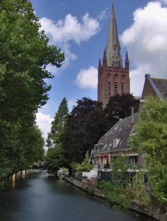
The city has an old town, surrounded by a small canal. A castle stood in IJsselstein from 1300 to 1888; the tower survives. The city has two large churches, both named after St. Nicholas: the Dutch Reformed Nicolaas church, founded in 1310, and a Roman Catholic one. Inside the Protestant church there are two mausoleums; one of the family of Gijsbrecht van Amstel (1350) and another one of Aleida van Culemborg (1475). The catholic basilica of St. Nicolaas dates from 1887 and is neo-gothic. It was given the title of 'Basilica Minor' by Pope Paul VI in 1972.
A 366.8 metres high television mast, called the Gerbrandy Tower, is located in IJsselstein. The tower is commonly, and erroneously, referred to as Zendmast Lopik, after the nearby village of Lopik.