
Population 585 (2011) Sovereign state United Kingdom Local time Friday 11:06 AM | OS grid reference TF513764 Post town Alford | |
 | ||
Weather 8°C, Wind SW at 35 km/h, 71% Humidity | ||
Huttoft is a small village in the East Lindsey district of Lincolnshire, England. It is situated approximately 4 miles (6 km) east from the market town of Alford, and on the A52 road between Ingoldmells and Sutton-on-Sea.
Contents
Map of Huttoft, Alford, UK
Etymology
Huttoft is listed three times in the 1086 Domesday Book as Hotoft, in the manors of both Huttoft and Greetham in the Calcewath Hundred of the South Riding of Lindsey. The combined listings record over 19 households, and 20 villagers, 23 smallholders, 69 freemen, 20 ploughlands, and meadows of 860 acres (3.5 km2). Before the Norman Conquest Earl Harold was lord of Greetham; this in 1086 transferred to Earl Hugh of Chester who also became tenant-in-chief to King William I. The 1086 tenant-in-chief of Huttoft was Alfred of Lincoln.
Huttoft is an Anglo-Norse place name derived from Old English hoh "decline", "slope" and Old Norse topt "site of a house". However, the Dictionary of British Place Names defines Huttoft as a "homestead on a spur of land." De Beaurepaire states that it is the same name as the Hottot; Hotot (f. e. Hotot-en-Auge) ; Hautot (former Hotot. f. e. Hautot-sur-Seine) in Normandy.
Landmarks
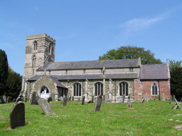
St Margaret's Church is built of stone in the decorated style, and is a Grade I listed building. Built of greenstone, limestone, and with some brick patching, Restorations took place in 1869, 1882, and 1910. The west tower is 13th-century, although it was extended in the 14th century. The font is 15th-century, although the cover is 19th-century. The churchyard cross, is a Grade II listed structure, which was restored in 1896 with the addition of a crucifix.
The Wesleyan Methodist chapel on Sutton Road, Huttoft, became part of the Alford, Skegness and Wainfleet Methodist Circuit in 1997.
The Primitive Methodists also had a chapel in Church Lane, which was on the Alford Methodist circuit until 1963, and has since been demolished although the graveyard remains.
Huttoft windmill is situated in the centre of the village and is a Grade II listed building. It lost its sails in 1945 in a storm after a century of milling.
Huttoft School was built as a National School in 1840, and was enlarged in 1874. It was known as Huttoft CE School by 1914, and became Huttoft County Primary in 1947. It became a Grant Maintained school and has been known as Huttoft Primary (GM) School since 1999.
Situated about 2.5 miles (4.0 km) east, Huttoft Bank Pit is a nature reserve protected by the Lincolnshire Wildlife Trust. It provided clay for repairs to the sea bank after the North Sea flood of 1953. There is a large open water area and extensive reedbeds. Huttoft Bank leads to Huttoft Beach, also known as Moggs Eye.
Huttoft is the location of the Radcliffe Donkey Sanctuary.