
Formed September 6, 2005 Fatalities 1 direct, 2 indirect Highest winds 137 km/h | Dissipated September 23, 2005 Damage $70 million (2005 USD) | |
 | ||
Lowest pressure 976 mbar (hPa); 28.82 inHg Areas affected Bahamas, Florida, South Carolina, North Carolina, Virginia, East Coast of the United States, Atlantic Canada, Europe Date 6 September 2005 – 23 September 2005 Similar Hurricane Nate, Hurricane Philippe, Hurricane Maria, Hurricane Irene, Hurricane Cindy | ||
Hurricane Ophelia was the fifteenth named tropical cyclone and the eighth hurricane of the 2005 Atlantic hurricane season. It was a long-lived storm that was most remembered for its very erratic and extremely slow track off the East Coast of the United States, alternating several times between tropical storm and hurricane intensity.
Contents
- Meteorological history
- Preparations
- Southeastern United States
- North Carolina
- New England and Canada
- References
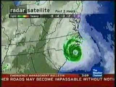
Ophelia caused some damage and beach erosion along the United States coastline from Florida to North Carolina, with its closest approach occurring on September 14 and 15 with its western eyewall crossing land and the eye remaining just offshore. Minimal damage and erosion was also reported in Atlantic Canada when Ophelia hit as a tropical storm in extratropical transition on September 17 and 18.
Meteorological history
On September 6 a non-tropical low over the northern Bahamas became more organized and formed into Tropical Depression Sixteen between Andros and Grand Bahama. Shortly after forming the depression moved over Grand Bahama and moved north parallel to the Florida coastline. The computer models initially predicted two distinct possibilities for the storm's future with some models indicating the storm would cross over Florida and enter the Gulf of Mexico while others indicated that it would stay offshore and move to the northeast. The official forecast from the National Hurricane Center followed the first set of guidance, though with low confidence. The storm strengthened to become Tropical Storm Ophelia early on September 7 and became a hurricane briefly the next day.
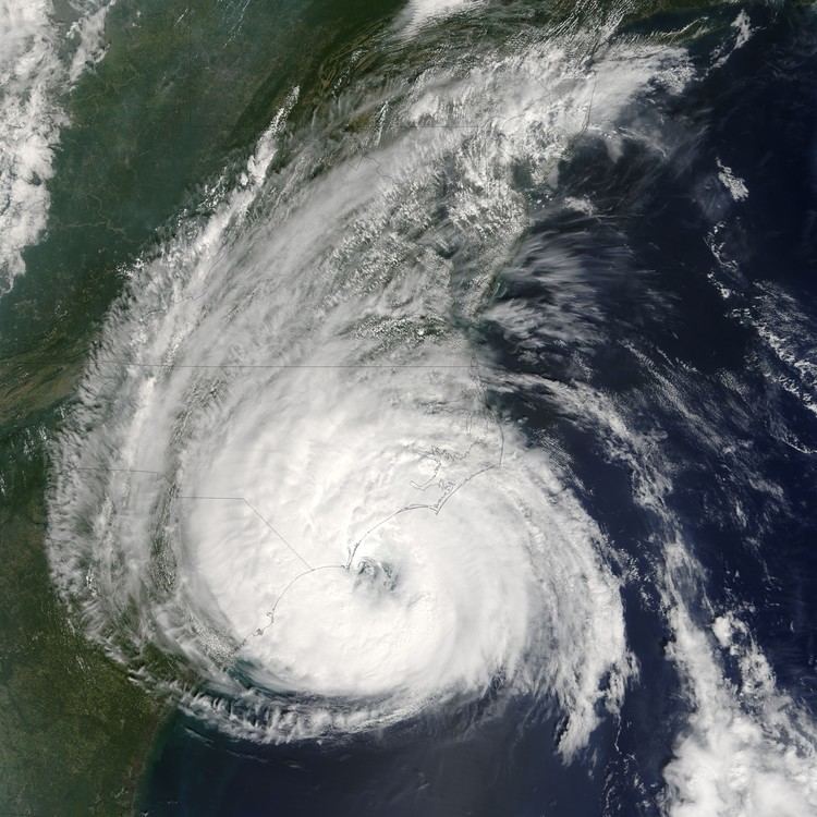
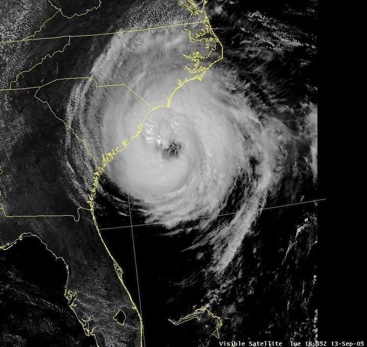
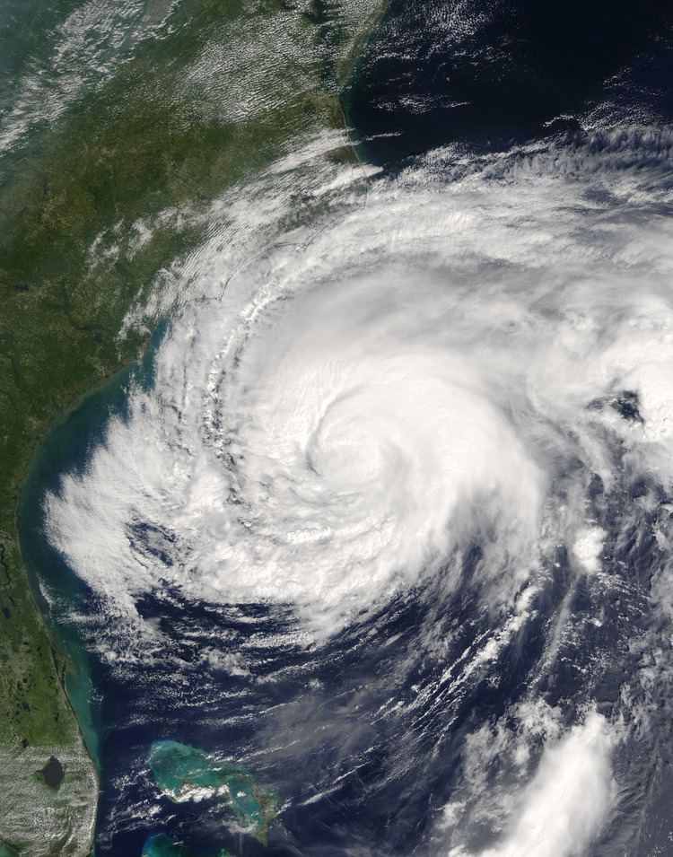
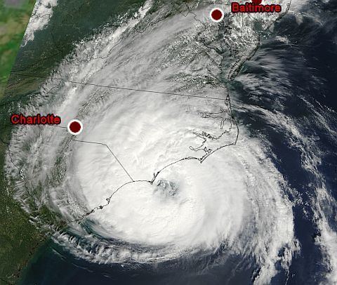
From September 9 to September 11, Ophelia fluctuated in strength, being downgraded to a tropical storm only to regain hurricane intensity three more times; during this time it moved very slowly and erratically in a northeasterly direction. The NHC continued to struggle to predict Ophelia, with the forecasts generally calling for a landfall on the east coast of the United States. The forecasters indicated there was a possibility that Ophelia could strengthen further to Category 3 strength, though they felt this was unlikely. On September 12 the storm completed a clockwise loop, then adopted a more north-westerly motion towards North Carolina, while still moving only slowly and fitfully. It dropped below hurricane strength again when the inner core of convection collapsed, possibly due to passing over cooler water that it upwelled earlier in its track. Ophelia then regained hurricane strength over the warm waters of the Gulf Stream. After the collapse of the inner core of convection, the hurricane acquired an unusually large eye over 115 miles (185 km) across and soon reached its peak strength with 85 mph (140 km/h) winds. The northern and western eyewall passed over the coastal areas of North Carolina throughout September 14–15, but the strongest winds remained offshore.
As Hurricane Ophelia moved past Cape Hatteras it turned to the east. Wind shear increased on September 16 and weakened Ophelia into a tropical storm for the last time. Ophelia turned to the northeast and brushed past Nantucket Island, Massachusetts the next day. As it approached Nova Scotia on September 17, the storm became extratropical but maintained its strength as it made landfall in the extreme eastern portion of the province. The extratropical storm passed over southern Newfoundland later that day and finally dissipated on September 23 in the North Sea.
Preparations
As soon as Tropical Depression Sixteen formed on September 6, the government of the Bahamas issued a tropical storm warning for the northwestern Bahamas and the National Hurricane Center issued a tropical storm warning for much of the east Florida coastline. On September 10, with forecasts indicating that Ophelia would make landfall in South Carolina as a hurricane, the NHC issued a hurricane watch for much of the coastline of the Carolinas. As the storm neared the Outer Banks, the watch was upgraded to a warning for the areas closest to the predicted route of the storm. On Ocracoke Island, roughly 3,000 tourists and 800 local residents were evacuated to inland shelters after a mandatory evacuation order was issued for the island.
As Ophelia was predicted to pass near southeast New England, the NHC issued tropical storm warnings for much of the south Massachusetts and Rhode Island coastlines. In Atlantic Canada, considerable preparations were taken for Ophelia, primarily because of memories of Hurricane Juan of the 2003 season, which had caught the authorities off-guard. Ophelia prompted the Canadian Hurricane Centre's first ever tropical storm warnings which were canceled when Ophelia became extratropical.
Southeastern United States
Before Ophelia made its closest approach to land near the Outer Banks on September 15 and 16, it caused moderate beach erosion along the Florida, Georgia, and South Carolina. Average swells of 6 to 8 ft (1.8 to 2.4 m) affected the region for several days as the storm meandered offshore. Squall lines associated with the storm brought moderate to heavy rains along with high winds, gusting to 62 mph (100 km/h) in isolated thunderstorms. Along the northeastern coast of Florida, up to 5.04 in (128 mm) of rain fell; some areas recorded 3.5 in (89 mm) in a six-hour span on September 6. Between September 6 and 9, torrential rainfall, measured up to 15.2 in (390 mm) in Flagler County, led to moderate street flooding, especially along poorly drained secondary roads. At Flagler Beach, Florida, the erosion endangered the foundation of highway A1A, and 140 dump trucks were brought in to buttress the road with rocks and sand. In Palm Beach County, one man drowned after being caught in rough seas associated with Ophelia.
North Carolina
Ophelia moved extremely slowly in and around North Carolina, causing the storm to drop more than 10 inches (254 mm) of rain on many coastal areas. The highest amount measured was from Oak Island, where 17.5 inches (445 mm) was registered. In addition, storm surges of 7–12 feet (2–4 m) were recorded, particularly in low-lying inlets of Pamlico Sound. At the storm's peak, over 240,000 customers were without power in coastal North Carolina. One indirect fatality was reported due to a traffic accident related to Ophelia, although no direct deaths were recorded.
Damage was heaviest in Salter Path, North Carolina and along the Outer Banks near that community, where (despite being only a Category 1 storm) many buildings suffered significant damage as a result of the storm surge, which has been described as worse than Hurricane Isabel in 2003 and even compared to Hurricane Hazel in 1954. Nearly all of the significant damage occurred on the sound side, or the side facing the mainland. In addition, several piers and many boats were damaged or destroyed by Ophelia's storm surge. Damage was generally lighter on the mainland, and overall structural damage was relatively light, although there was considerable flooding reported in the Wilmington area. Damage was initially estimated to be about $1.6 billion, but in final analysis was dropped to only $70 million (2005 USD; $77.3 million 2008 USD). On October 7, President George W. Bush declared a state of emergency for ten counties in North Carolina as a result of Ophelia.
New England and Canada
In New England and Canada, overall damage was minimal, and only brief, sporadic power outages were reported. One indirect storm-related fatality was reported in Nova Scotia as a result of a person falling during minor roof repairs. In Newfoundland, over 1.96 inches (50 millimeters) of rain fell over parts of the eastern region of the province.