
Fatalities 38 direct | Highest winds 169 km/h | |
 | ||
Formed August 20, 1950 (1950-08-20) Dissipated September 1, 1950 (1950-10) Lowest pressure 978 mbar (hPa); 28.88 inHg Damage $2.55 million (1950 USD) Date 20 August 1950 – 1 September 1950 Similar Hurricane Able, Hurricane Dog, Hurricane Easy, Hurricane Klaus, Hurricane Ethel | ||
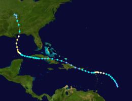
Hurricane Baker was a major hurricane that affected the Leeward Islands, Greater Antilles, and the Gulf Coast of the United States. The tropical cyclone was the second intense hurricane, second hurricane, and second tropical storm of the 1950 Atlantic hurricane season. Hurricane Baker attained peak winds of 120 mph (195 km/h) near the Leeward Islands, traversed Antigua, and weakened to a tropical depression southwest of Puerto Rico. It re-intensified south of Cuba, strengthened to a strong Category 2 hurricane in the Gulf of Mexico, and hit the United States near Gulf Shores, Alabama, with winds of 85 mph (140 km/h). Hurricane Baker produced extensive damage in the Lesser Antilles and Cuba, but impacts were minimal in the United States.
Contents
Meteorological history
On the morning of August 20, a strong tropical storm developed about 446 miles (718 km) east of Basse-Terre, Guadeloupe. The tropical storm deepened to hurricane intensity. On August 21, it rapidly attained maximum sustained winds of 120 mph (195 km/h), equivalent to a Category 3 hurricane. The hurricane passed over Antigua during the evening, while still producing winds of 115 mph (185 km/h). On August 22, it lost intensity and weakened to a tropical storm. On August 23, Baker made landfall near the Puerto Rican town of Guánica as a minimal tropical storm. The highest winds on the island of Puerto Rico were 35–40 mph (55–65 km/h). The storm then degenerated into an easterly tropical wave, and moved west-northwestward over northeastern Hispaniola. On August 24, it re-entered the Atlantic Ocean, and Tropical Depression Baker crossed the coast of eastern Cuba early on the next day.
On August 25, Baker redeveloped a center over the Caribbean Sea off southern Cuba, and re-intensified to tropical storm status. On August 27, Baker affected the Pinar del Río Province with 60 mph (75 km/h) winds, and then turned northward over the southern Gulf of Mexico. On August 28, Baker re-strengthened to hurricane intensity; reconnaissance and ship reports suggest the hurricane attained a second peak intensity of 110 mph (175 km/h) on August 30. The minimum central pressure was 979 mbar (28.92 inHg) on this date. The cyclone diminished in intensity prior to landfall. On August 31, the hurricane struck Gulf Shores, Alabama as a Category 1 hurricane with sustained winds estimated near 85 mph (140 km/h). The estimated central pressure at landfall was 980 mbar (28.95 inHg). Baker moved inland over Alabama and dissipated over southeastern Missouri on September 1.
Impact
On Antigua, the Pan American Airways station's power failed when winds reached 85 mph (140 km/h) around midnight on August 22. Unofficial estimates placed winds between 95–120 mph (150–195 km/h) at the location, although damages and casualties were unknown. Subsequent reports indicated light damage occurred on the island; later, information from the island indicated extensive damage. More than 100 homes were destroyed or damaged in the Willkie and Piggott areas, and large homes were destroyed in Prestown. Additionally, a manse was also demolished in Prestown. Electronic communications were dismantled, and thousands of homeless people sheltered in churches and schools. No deaths occurred on the island, but damages were expected to reach several thousand dollars. In Cuba, 37 people died, and the property losses reached several million dollars.
In the United States, the greatest property and crop damage occurred from Mobile, Alabama to Saint Marks, Florida, where losses approached $2,550,000 (1950 USD); high tides and winds inflicted minimal damage in both cities. Panama City, Florida incurred heavy damage to homes and businesses from high tides and rainfall, which peaked at 14.96 inches (380 mm). The highest rainfall total was 15.49 inches (393 mm) at Caryville, Florida. Peak gusts exceeded 100 mph (155 km/h) on Santa Rosa Island, Florida. 200 to 300 cottages received damage in Panama City, and homes were flooded near the bay. Losses reached $200,000 (1950 USD) in Gulf Shores, Alabama. Hurricane Baker spawned two tornadoes. On August 30, a F1 tornado touched down in Apalachicola, Florida, destroying four dwellings and a store building and damaging another eleven buildings. On August 31, a F0 tornado demolished one building near Marianna, Florida, in Jackson County. Inland, Birmingham International Airport recorded 50 mph (85 km/h) wind gusts; higher gusts were estimated near 75 mph (120 km/h) in elevated, mountainous locations. Hundreds of trees were prostrated as far north as the Birmingham, Alabama area, and one person was killed and two more injured by live wires falling from utility poles.