
Dissipated June 1, 2001 (2001-07) Damage None Highest winds 233 km/h Date 25 May 2001 – 1 June 2001 | Fatalities None | |
 | ||
Formed May 25, 2001 (2001-05-25) Lowest pressure 938 mbar (hPa); 27.7 inHg Similar Hurricane Fefa, Hurricane Fico, Tropical Storm Hazel, Hurricane Kiko, Hurricane Ismael | ||
Hurricane Adolph of the 2001 Pacific hurricane season was the first and one of only two East Pacific hurricanes in May to reach Category 4 strength on the Saffir-Simpson Hurricane Scale since record keeping began in the East Pacific. The name was also retired due to sensitivities surrounding the use of Adolf Hitler's first name. Adolph was the first depression of the season, forming on May 25; it became a hurricane three days later. After rapidly intensifying, Adolph became the most powerful storm in terms of maximum sustained winds this season, along with Hurricane Juliette. It dissipated on June 1 after moving over colder waters after briefly threatening land.
Contents
Meteorological history
On May 7, a tropical wave left the coast of Africa. The wave moved across the Atlantic Ocean showing little signs of development until May 18, when a low pressure center began organizing along the wave over Costa Rica and Panama. The low entered the Pacific Ocean on May 22, and Dvorak classifications—satellite-based intensity estimates—began two days later. At first the system was disorganized, but convection quickly concentrated near the center, and on May 25 the disturbance developed into Tropical Depression One-E while located about 250 miles (400 km) south-southwest of Acapulco, Mexico.
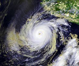
The newly formed depression moved very slowly due to weak steering currents aloft. Moving towards the east-northeast over weak steering currents, the computer models used to predict the movement of the depression varied greatly, with one predicting an eventual Mexican landfall. Located in conditions ideal for tropical development, the developing cyclone formed a central dense overcast, a large area of deep convection. The depression steadily intensified to become Tropical Storm Adolph on May 26 about 225 mi (362 km) south-southwest of Acapulco. Adolph was in a low wind shear environment with warm sea surface temperatures and as such, the NHC forecasted intensification to hurricane status within two days. Adolph turned northward on May 27, a turn influenced by a mid-level ridge building to the east and southeast, thus causing the tropical storm to approach Mexico. A banding eye feature, a type of eye common in minor hurricanes, became apparent on satellite imagery. Convection around the eye deepened while the eye became more pronounced, and Adolph was upgraded to hurricane strength on May 27. On May 28, the hurricane passed within roughly 165 mi (265 km) of the Mexican coastline the next day, its closest approach to land. Shortly thereafter, Adolph turned westward under the influence of a mid-tropospheric ridge. The high upper-oceanic heat content, good outflow, and lack of vertical shear allowed the hurricane to begin a burst of rapid intensification, dropping 1.46 mbars per hour. While reducing in size, Adolph reached its peak strength of 145 mph (230 km/h) on May 29. Dvorak classifications reported a T-number of 7.0 for Adolph, equivalent to a low-end Category 5 hurricane on the Saffir-Simpson Hurricane Scale. However, because of a lack of data from the storm via Hurricane Hunters, these strength measurements may be disputed.
After peaking in intensity, Adolph weakened while decelerating westward due to an eyewall replacement cycle; by May 30, the winds dropped to 115 mph (185 km/h) as the eyewall became cloud filled and became less distinct. The trend of weakening continued as the eye definition and convection oscillated in presentation. On June 1 Adolph deteriorated into a tropical storm as convection became exposed from the increasingly elongated center. As the storm passed over increasingly colder waters and into an area of stable air, the system weakened more quickly, and dissipated on June 1, while located about 460 miles (740 km) south-southwest of Baja California. The remaining clouds persisted for a few days before dissipating entirely.
Impact and records
Though Adolph never moved ashore, its close approach to land as well as its slow, unpredictable movement resulted in the issuance of a tropical storm warning and a hurricane watch for southern Mexico around the time when the cyclone attained major hurricane strength. The threat for heavy rainfall was mentioned for areas from Puerto Ángel to Zihuatanejo when Adolph was a depression and later from Acapulco to Lázaro Cárdenas. The government of Mexico expressed concern that rain and 13-foot (4.0 m) waves from Adolph would affect Oaxaca, Colima, Jalisco, Michoacán, and Guerrero. The hurricane was responsible for the closure of ports in Acapulco to small vessels.
Despite the tropical storm warning and forecasts of minor impacts, no tropical storm force winds from Adolph were reported on land; the only reported tropical storm force winds were given by a ship called the Seurat, which recorded sustained winds of 45 mph (72 km/h) on May 29. Outside of some reports of rain and heavy surf, no reports of casualties or damages were received in connection with the storm.
When Adolph reached Category 4 strength on May 29, it became the strongest hurricane to form in the East Pacific basin in May, a record not surpassed until 2014's Hurricane Amanda attained peak winds of 155 mph (250 km/h). At that time, Adolph also became first recorded May hurricane to reach Category 4 strength.
The name Adolph has subsequently been retired by the World Meteorological Association, amid concern that future use of the name would be politically insensitive.