
Population 134 (2011 census) Postal code 2111 | Postcode(s) 2111 Huntleys Point Hunters Hill | |
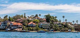 | ||
Huntleys Point is a suburb on the Lower North Shore of Sydney, in the state of New South Wales, Australia. Huntleys Point is located 9 kilometres north-west of the Sydney central business district, in the local government area of the Municipality of Hunter's Hill. Huntleys Point sits on the northern shore of the Parramatta River.
Contents
Map of Huntleys Point NSW 2111, Australia
History
Huntley's Point was named by Alfred Huntley who purchased the land here and built Point House in 1851. He had arrived in the colony with his family in 1836 and his father Dr Robert Huntley first occupied land in Braidwood that is known as Huntley's Flats.
Alfred Huntley opened Turkish baths in Bligh Street, in the city on the present site of Adyar House and later he became the chief engineer for Australian Gas Light Company. His only child, a son also named Alfred became a brilliant scholar at The King's School, Parramatta and later was an architect and civil engineer, building some of the stone houses at Hunters Hill.
Transport
The Gladesville Bridge spans the Parramatta River and connects Huntley's Point to Drummoyne. Tarban Creek Bridge links Huntley's Point north to Hunters Hill. The bridges are part of a complex of three bridges that also includes Fig Tree Bridge and links traffic between Victoria Road and Burns Bay Road. Huntleys Point ferry wharf provides access to the Parramatta River ferry services.