
Country United States Elevation 171 ft (52 m) Local time Thursday 6:41 PM Area code Area code 323 | State California Incorporated September 1, 1906 Population 58,879 (2013) | |
 | ||
Weather 21°C, Wind SW at 6 km/h, 58% Humidity Colleges and Universities UEI College, Huntington Park, United Education Institute-Huntington Park Campus | ||
Huntington Park is a city in the Gateway Cities district of southeastern Los Angeles County, California.
Contents
- Map of Huntington Park CA USA
- History
- Pacific Boulevard
- Geography
- 2012
- 2010 census
- 2000 census
- Latino communities
- Government and infrastructure
- Transportation
- Education
- Public libraries
- Notable people
- References
Map of Huntington Park, CA, USA
As of the 2010 census, the city had a total population of 58,114, down from 61,348 at the 2000 census.
History
Named for prominent industrialist Henry E. Huntington, Huntington Park was incorporated in 1906 as a streetcar suburb for workers in the rapidly expanding industries to the southeast of downtown Los Angeles. To this day, about 30% of its residents work at factories in nearby Vernon and Commerce. The stretch of Pacific Boulevard in downtown Huntington Park was a major commercial district serving the city's largely working-class residents, as well as those of neighboring cities such as Bell, Cudahy, South Gate, and Downey. As with most of the other cities along the corridor stretching along the Los Angeles River to the south and southeast of downtown Los Angeles, Huntington Park was an almost exclusively white community during most of its history; Alameda Street and Slauson Avenue, which were fiercely defended segregation lines in the 1950s, separated it from black areas.
The changes that shaped Los Angeles from the late 1970s onward—the decline of American manufacturing that began in the 1970s; the rapid growth of newer suburbs in Orange County, the eastern San Gabriel, western San Fernando and Conejo valleys; the collapse of the aerospace and defense industry at the end of the Cold War; and the implosion of the Southern California real estate boom in the early 1990s—resulted in the wholesale departure of virtually all of the white population of Huntington Park by the mid-1990s. The vacuum was filled almost entirely by two groups of Latinos: upwardly mobile families eager to leave the barrios of East Los Angeles, and recent Mexican immigrants. Today, Pacific Boulevard is once again a thriving commercial strip, serving as a major retail center for working-class residents of southeastern Los Angeles County—but unlike its previous heyday of the 1930s, the signs along the avenue's storefronts are now primarily in Spanish.
A weekly certified farmers market is now hosted at Salt Lake Park (opposite the Recreation Center on Bissell Street) every Wednesday from 9am-1:30pm. The market includes year round as well as seasonal vendors that provide access to the following products: Bee products, eggs, fruits and fruit products, herbs, nuts, plants, vegetables, granola, nuts, corn, etc.
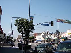
Pacific Boulevard
On November 18, 1930, the Warner's Theater at 6714 Pacific Boulevard, opened and its first attraction was "The Life of the Party". It had 1,468 seats. This theater has been closed for decades. It was bought by Pacific Boulevard Holdings/ Retail Management Corp for $1,600,000. California Theatre opened on 1925 and was operated by Fox Theatres as the Fox California Theatre. In the 80s it was known as the California 3 Theatre. This theatre close in 2006 and was later converted into a retail space. It was renamed California 2 Theatres and now there is a Tuxedo shop along with other retail stores and restaurants.
During the 2014 World Cup, Mexico won the game between Croatia to move on to the next round and Pacific Boulevard was closed down because people filled the streets celebrating. All retail stores and restaurants were told to close. The cops were in riot gear and on horseback to keep the residents safe and making sure no damage was made. Five people were arrested at the moment.
Geography
Huntington Park is located at 33°59′N 118°13′W (33.982, -118.217). Before California abolished judicial townships (some time after 1960), Huntington Park was located in San Antonio Township.
According to the United States Census Bureau, the city has a total area of 3.0 square miles (7.8 km2), all land.
Cities surrounding Huntington Park include Bell, Cudahy, Los Angeles, Maywood, South Gate, and Vernon. In addition unincorporated areas, including Florence-Graham and Walnut Park, are adjacent to Huntington Park.
2012
A 2012 study by the California Center for Public Health Advocacy found Huntington Park California had the highest percentage of overweight children in all of California with 53% of the city's child population being obese or overweight.
2010 census
The 2010 United States Census reported that Huntington Park had a population of 58,114. The population density was 19,270.0 people per square mile (7,440.2/km²). The racial makeup of Huntington Park was 56,445 (97.1%) Hispanic or Latino, 29,776 (51.2%) White (1.6% Non-Hispanic White), 440 (0.8%) African American, 752 (1.3%) Native American, 393 (0.7%) Asian, 28 (0.0%) Pacific Islander, 24,535 (42.2%) from other races, and 2,190 (3.8%) from two or more races.
The Census reported that 57,859 people (99.6% of the population) lived in households, 248 (0.4%) lived in non-institutionalized group quarters, and 7 (0%) were institutionalized.
There were 14,597 households, out of which 8,581 (58.8%) had children under the age of 18 living in them, 7,461 (51.1%) were opposite-sex married couples living together, 3,212 (22.0%) had a female householder with no husband present, 1,623 (11.1%) had a male householder with no wife present. There were 1,377 (9.4%) unmarried opposite-sex partnerships, and 81 (0.6%) same-sex married couples or partnerships. 1,644 households (11.3%) were made up of individuals and 694 (4.8%) had someone living alone who was 65 years of age or older. The average household size was 3.96. There were 12,296 families (84.2% of all households); the average family size was 4.19.
The population was spread out with 18,439 people (31.7%) under the age of 18, 6,984 people (12.0%) aged 18 to 24, 17,886 people (30.8%) aged 25 to 44, 10,942 people (18.8%) aged 45 to 64, and 3,863 people (6.6%) who were 65 years of age or older. The median age was 28.9 years. For every 100 females there were 99.6 males. For every 100 females age 18 and over, there were 97.8 males.
There were 15,151 housing units at an average density of 5,023.9 per square mile (1,939.7/km²), of which 3,936 (27.0%) were owner-occupied, and 10,661 (73.0%) were occupied by renters. The homeowner vacancy rate was 1.5%; the rental vacancy rate was 3.2%. 18,054 people (31.1% of the population) lived in owner-occupied housing units and 39,805 people (68.5%) lived in rental housing units.
During 2009–2013, Huntington Park had a median household income of $36,397, with 28.7% of the population living below the federal poverty line.
2000 census
According to the census of 2000, there were 61,348 people, 14,860 households, and 12,660 families residing in the city. The population density was 20,252.4 inhabitants per square mile (7,817.4/km²). There were 15,335 housing units at an average density of 5,062.4 per square mile (1,954.1/km²). The racial makeup of the city was 41.4% White, 0.8% Black or African American, 1.0% Native American, 0.80% Asian, 0.1% Pacific Islander, 51.1% from other races, and 4.9% from two or more races. 95.6% of the population were Hispanic or Latino of any race.
As of 2000, speakers of Spanish as their first language accounted for 90.77% of residents, while English was spoken by 9.17%, Chinese by 0.05% of the population.
There were 14,860 households out of which 58.3% had children under the age of 18 living with them, 55.4% were married couples living together, 20.3% had a female householder with no husband present, and 14.8% were non-families. 10.9% of all households were made up of individuals and 4.8% had someone living alone who was 65 years of age or older. The average household size was 4.12 and the average family size was 4.34.
In the city, the population was spread out with 35.8% under the age of 18, 13.0% from 18 to 24, 32.3% from 25 to 44, 13.8% from 45 to 64, and 5.1% who were 65 years of age or older. The median age was 26 years. For every 100 females there were 100.3 males. For every 100 females age 18 and over, there were 98.3 males.
The median income for a household in the city was $28,941, and the median income for a family was $29,844. Males had a median income of $21,039 versus $16,733 for females. The per capita income for the city was $9,340. About 23.3% of families and 25.2% of the population were below the poverty line, including 31.5% of those under age 18 and 18.7% of those age 65 or over.
Latino communities
These were the ten cities or neighborhoods in Los Angeles County with the largest percentage of Latino residents, according to the 2000 census:
Government and infrastructure
Fire protection in Huntington Park is provided by the Los Angeles County Fire Department. The LACFD operates Station #164, the battalion headquarters, at 6301 South Santa Fe Avenue and Station #165 at 3255 Saturn Avenue, both in Huntington Park, as a part of Battalion 13. The Huntington Park Police Department provides law enforcement.
The Los Angeles County Department of Health Services operates the Whittier Health Center in Whittier, serving Huntington Park.
In the California State Senate, Huntington Park is in the 33rd Senate District, represented by Democrat Ricardo Lara.
In the California State Assembly, Huntington Park is split between the 53rd Assembly District, represented by Democrat Miguel Santiago, and the 59th Assembly District, represented by Democrat Reggie Jones-Sawyer.
In the United States House of Representatives, Huntington Park is in California's 40th congressional district, represented by Democrat Lucille Roybal-Allard.
The United States Postal Service operates the Huntington Park Post Office at 6606 Seville Avenue, the Soto Post Office at 5625 Soto Street, and the State Street Post Office at 7800 State Street.
Transportation
Bus services are provided by both the Los Angeles County Metropolitan Transportation Authority (Metro), and Huntington Park's own COMBI bus service.
Education
Huntington Park is zoned to schools in the Los Angeles Unified School District.
Public elementary schools that serve the city include:
Public middle schools include:
Public high schools include:
Most residents are zoned to Huntington Park High School or Linda Esperanza Marquez High School (opened 2012). Some residents of Huntington Park are zoned to Bell High School in Bell, and some areas are jointly zoned to both schools. Any student who lives in the Bell or Huntington Park zones may apply to Maywood Academy High School in Maywood; Maywood Academy, which opened in 2005 and moved into its permanent campus in 2006, does not have its own attendance boundary because it lacks American football, track and field, and tennis facilities.
San Antonio Continuation School and Huntington Park College Ready Academy (a public charter school) also serve the high school population. Some parts of Huntington Park are zoned to both Huntington Park and Bell High School.
The groundbreaking for South Region High School 7 in Huntington Park occurred in 2010. The school was scheduled to open in 2012.
In addition Pacific Boulevard Special Education Center (ungraded) is in the city.
Private schools include:
Public libraries
County of Los Angeles Public Library operates the Huntington Park Library at 6518 Miles Avenue.