
 | ||
Similar Horse Sand Fort, Maunsell Forts, Cleethorpes Coast Light Railway, Cleethorpes Pier, Grimsby Dock Tower | ||
Humber forts
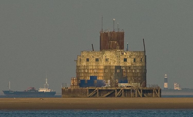
The Humber Forts are two large fortifications in the mouth of the Humber estuary in northern England: Haile Sand Fort (53°32′4″N 0°2′1″E) and Bull Sand Fort (53°33′43″N 0°4′3″E).
Contents
History
The two forts were planned in 1914 to protect the entrance to the estuary. They stand 59 feet (18 m) above the water and have a diameter of 82 feet (25 m). There was accommodation for 200 soldiers. Started in May 1915, they took more than four years to build and construction was not finished until December 1919.
During the Second World War they were reactivated and modernised. The forts were regularly attacked by enemy aircraft. During this time, they installed a netting to prevent enemy submarines from travelling up the estuary to Hull or Grimsby. The forts were finally abandoned by the military in 1956.
Haile Sand Fort or Sand Haile Fort is the smaller of the two and is situated around the low-water mark between Cleethorpes and Humberston on the Lincolnshire coast. In February 2016 the fort was put on the market for £350,000.
Haile sand fort was reduced in price in May this year, and is currently on the market for £300,000.
Bull Sand Fort is 1.5 miles (2.4 km) from shore off Spurn Head. It is a 4-storey concrete building with 12-inch (300 mm) of armour on the seaward side, and originally armed with four 6-inch guns. It was built with great difficulty as its sandbank is 11 feet (3.4 m) below low water.
In 1987 it was given a Grade II Listed Building status. In 1997 it was sold to the Streetwise Charitable Trust, who are restoring the fort for use as a drug rehabilitation facility. Administratively, it is within the East Riding of Yorkshire and civil parish of Easington, East Riding of Yorkshire.