
UBIGEO 1005 Region Huánuco Region | Area 3,144 km² | |
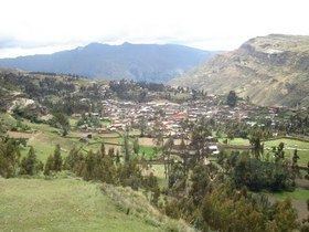 | ||
The Huamalíes Province is one of eleven provinces of the Huánuco Region in Peru. The capital of this province is the city of Llata.
Contents
- Map of HuamalC3ADes Province Peru
- Boundaries
- Geography
- Political division
- Ethnic groups
- Archaeology
- References
Map of Huamal%C3%ADes Province, Peru
Boundaries
Geography
Some of the highest mountains of the province are listed below:
Political division
The province is divided into eleven districts, which are:
Ethnic groups
The people in the province are mainly indigenous citizens of Quechua descent. Quechua is the language which the majority of the population (53.30%) learnt to speak in childhood, 46.23% of the residents started speaking using the Spanish language (2007 Peru Census).
Archaeology
Some of the most important archaeological sites of the province are Anku, Awila Qhincha Mach'ay, Awkin Punta, Awqa Punta, Isuq, K'ipakhara, Miyu Pampa, Phiruru, Pumaq Hirka, Qillqay Mach'ay, Susupillu, Urpish, Wanqaran and Wat'a, some of which were declared a National Cultural Heritage.