
First mentioned 1778 Time zone MSK (UTC+4) Area 240 ha | Elevation 244 m (801 ft) Postal code 98020 Population 2,269 (2014) | |
 | ||
Weather 3°C, Wind NW at 6 km/h, 82% Humidity | ||
Hrushivka (Ukrainian: Грушівка; Russian: Грушевка) is a village in the Sudak Municipality of the Autonomous Republic of Crimea, a territory recognized by a majority of countries as part of Ukraine and annexed by Russia as the Republic of Crimea.
Map of Hrushivka
Previously, the settlement was known as the Suuk-Sala village (Crimean Tatar: Suvuq Sala). Following the forced deportation of the Crimean Tatars in 1944, the Presidium of the Supreme Soviet of the Russian SFSR published a decree on May 18, 1948 renaming the settlement along with many others throughout Crimea from their native Crimean Tatar names to their current variants.
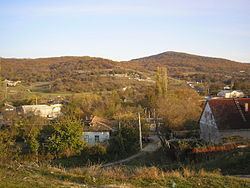
Hrushivka is located on Crimea's southern shore at an elevation of 244 metres (801 ft). Its population was 2,054 in the 2001 Ukrainian census. Current population: 2,269 (2014 Census).