
Elevation 195 m Local time Wednesday 9:52 PM | Postal code 671 68 Area 16.05 km² | |
 | ||
Weather 8°C, Wind NW at 13 km/h, 67% Humidity | ||
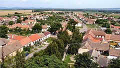
Hrabětice (German: Grafendorf) is a village and municipality (obec) in Znojmo District in the South Moravian Region of the Czech Republic.
Map of 671 68 Hrab%C4%9Btice, Czechia
The municipality covers an area of 16.05 square kilometres (6.20 sq mi), and has a population of 888.
Hrabětice lies approximately 29 kilometres (18 mi) east of Znojmo, 48 km (30 mi) south of Brno, and 204 km (127 mi) south-east of Prague.
References
Hrabětice Wikipedia(Text) CC BY-SA