
Postal code 739 97 Area 9.79 km² Local time Wednesday 10:59 PM | First mentioned 1577 Website www.obechradek.cz Elevation 353 m Population 1,812 (2006) | |
 | ||
Weather 1°C, Wind W at 10 km/h, 78% Humidity | ||
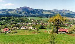
Hrádek (Polish: Gródek , German: Grudek) is a village in Frýdek-Místek District, Moravian-Silesian Region of the Czech Republic, on the Olza River. It has a population of 1,756 (2001 census), 42.8% of whom are Poles, the highest percentage of all municipalities in the country. The village lies between the mountain ranges of the Silesian Beskids and the Moravian-Silesian Beskids, in the historical region of Cieszyn Silesia.
Contents
Map of Hr%C3%A1dek, Czechia
The name of the village is a diminutive form of the word gord (Czech: Hrád, Polish: Gród)
History
The beginnings of the village can be traced back to the 12th century, when a small fort (gord) was built on a trade route running through the Jablunkov Pass. A settlement grew up around the fort. The small fort and its neighboring settlement were completely destroyed by the Magyars in 1447. Gródek was first mentioned in a written document in 1577 as Grudek. It belonged then to the Duchy of Teschen, a fee of the Kingdom of Bohemia and a part of the Habsburg Monarchy.
The village began to develop more briskly at the end of the 18th century, when about 900 people working mainly in agriculture lived there. After 1880 sandstone was exploited; its exploitation lasted until the outbreak of World War I.
After Revolutions of 1848 in the Austrian Empire a modern municipal division was introduced in the re-established Austrian Silesia. The village as a municipality was subscribed to the political district of Cieszyn and the legal district of Jablunkov. According to the censuses conducted in 1880, 1890, 1900 and 1910 the population of the municipality grew from 798 in 1880 to 886 in 1910 with the majority being native Polish-speakers (between 98.1% and 100%) accompanied by Czech-speaking (at most 6 or 0.7% in 1910) and German-speaking people (at most 5 or 0.6% in 1910) and in 1910 by 5 people speaking other languages. In terms of religion in 1910 the majority were Protestants (74.9%), followed by Roman Catholics (24.9%) and Jews (2 people). The village was also traditionally inhabited by Cieszyn Vlachs, speaking Cieszyn Silesian dialect.
After World War I, fall of Austria-Hungary, Polish–Czechoslovak War and the division of Cieszyn Silesia in 1920, it became a part of Czechoslovakia. Following the Munich Agreement, in October 1938 together with the Zaolzie region it was annexed by Poland, administratively adjoined to Cieszyn County of Silesian Voivodeship. It was then annexed by Nazi Germany at the beginning of World War II. After the war it was restored to Czechoslovakia.
From 1980 to 1990 the village was administratively a part of Jablunkov.
Bełko Rock legend
There is a legend connected with the ancient fort. Notable local landmark Skała Bełki (Bełko Rock) is supposed to be the place of death of the infamous legendary knight Bełko, who plundered merchants and murdered people. According to one version, he committed suicide when his conscience overwhelmed him; according to the second version, he fell down with his horse into the Olza River chasing a mirage of victims of his cruelty.