
Country Canada Incorporated 1957 Area code(s) 250 / 778 / 236 Area 72.94 km² Local time Wednesday 7:30 AM Number of airports 1 | Time zone PST (UTC-8) Elevation 610 m Population 3,147 (2011) | |
 | ||
Weather -4°C, Wind SE at 11 km/h, 95% Humidity | ||
October 13th 2016 snow in houston british columbia canada
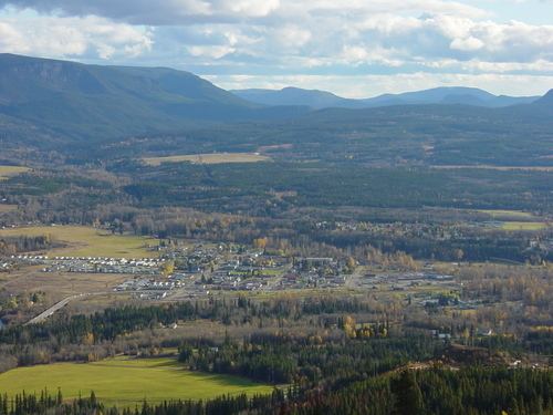
Houston /ˈhjuːstən/ is a forestry, mining and tourism town in the Bulkley Valley of the Northern Interior of British Columbia, Canada. Its urban population is approximately 3600 people, with approximately 2000 in the surrounding rural area. It is known as the "steelhead capital" and it has the world's largest fly fishing rod. Houston's tourism industry is largely based on eco-tourism and Steelhead Park, situated along Highway 16.
Contents
- October 13th 2016 snow in houston british columbia canada
- Map of Houston BC Canada
- History
- Geography
- Transportation
- Politics
- Recreation
- Schools
- Trivia
- References
Map of Houston, BC, Canada
History
The Morice area was first charted by amateur historian, cartographer and geologist, Reverend Adrien-Gabriel Morice (1859-1938) known to Northern British Columbian locals as "Father Morice." In 1880, Morice came to British Columbia as a Catholic missionary to the native people and was one of the first 'white men' to see most of the area. Morice wrote, The History of the Northern Interior of British Columbia (formerly New Caledonia) [1660 to 1880]. The Indigenous people were initially known as Carrier Indians, but today are more commonly referred to as the Wet'suwet'en and speak a language commonly referred to as Athapaskan. The Morice River was called "Wet-zuhn-kwa" by the Wet'suwet'en people because of the bluish-green color of the water.
Wet-zuhn-kwa produced many species of fish such as trout, dolly varden, spring salmon, sockeye salmon, pink salmon, coho salmon, and steelhead salmon. The area is also rich in wildlife as it is not uncommon to spot moose, deer, black bear, grizzly bear, cougars and so on. Nanika River feeds Morice Lake and produces sockeye salmon. Morice River is a tributary of the Skeena River system, which is the second-largest system in BC that enters the Pacific Ocean at Prince Rupert, B.C.
Geography
West of Houston are Telkwa, British Columbia (49 km.), Smithers, British Columbia (66), Moricetown, British Columbia (97), Old Hazelton, British Columbia, New Hazelton, British Columbia (130), Terrace, British Columbia (269), and Prince Rupert, British Columbia (413 km.). East of Houston are Topley, British Columbia (30 km.), Granisle, British Columbia (79), Burns Lake, British Columbia (81), Fraser Lake, British Columbia (150), and Prince George, British Columbia (304 km.).
Houston is located near the confluence of the Bulkley River and Morice River approximately 65 km (40 mi) south of Smithers along Highway 16.
The area is in a rainshadow of the Coast Mountains, however due to being dominated by a low pressure region, Houston receives a mid-range volume of precipitation annually.
Morice Lake is located 80 km (50 mi) south along the Morice River Forest Service Road (FSR). Nestled into the Coast Mountains, many Houstonites use this area for recreational camping and fishing.
Nearby communities:
Transportation
Via Rail's Jasper – Prince Rupert train calls at the Houston railway station several times per week.
Politics
Recreation
Schools
Houston is located in School District 54 Bulkley Valley and has three public schools and one privately run Christian denominational school.
Elementary schools:
Secondary Schools:
The Houston Christian School teaches from K-12.