
Time zone MST (UTC-7) Elevation 1,625 m Zip code 81419 Local time Tuesday 11:19 PM | Incorporated (town) March 14, 1901 FIPS code 08-37545 Area 236 ha Population 919 (2013) Area code 970 | |
 | ||
Weather 9°C, Wind NE at 11 km/h, 38% Humidity | ||
Mason morse ranch company 7 x ranch in hotchkiss colorado
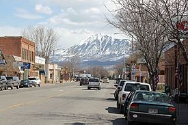
Hotchkiss is a statutory town in Delta County, Colorado, United States. The population was 944 at the 2010 census.
Contents
- Mason morse ranch company 7 x ranch in hotchkiss colorado
- Map of Hotchkiss CO USA
- Geography
- Demographics
- References
Map of Hotchkiss, CO, USA
A post office called Hotchkiss has been in operation since 1882. The town has the name of Enos T. Hotchkiss, a local pioneer.
Geography
Hotchkiss is located in eastern Delta County at 38°47′57″N 107°43′1″W (38.799275, -107.716976), on the north side of the North Fork Gunnison River.
Colorado State Highway 92 passes through the center of town as Bridge Street, leading west 20 miles (32 km) to Delta, the county seat, and southeast 52 miles (84 km) to U.S. Route 50 at Blue Mesa Reservoir. Colorado State Highway 133 starts at the east end of town and leads northeast 66 miles (106 km) over McClure Pass to Carbondale.
According to the United States Census Bureau, the town of Hotchkiss has a total area of 0.93 square miles (2.4 km2), all of it land.
Demographics
As of the census of 2000, there were 968 people, 412 households, and 271 families residing in the town. The population density was 1,452.8 people per square mile (557.8/km²). There were 451 housing units at an average density of 676.9 per square mile (259.9/km²). The racial makeup of the town was 93.18% White, 1.03% Native American, 0.52% Asian, 3.51% from other races, and 1.76% from two or more races. Hispanic or Latino of any race were 9.40% of the population.
There were 412 households out of which 31.6% had children under the age of 18 living with them, 51.7% were married couples living together, 9.7% had a female householder with no husband present, and 34.2% were non-families. 30.3% of all households were made up of individuals and 14.6% had someone living alone who was 65 years of age or older. The average household size was 2.34 and the average family size was 2.91.
In the town, the population was spread out with 25.6% under the age of 18, 9.6% from 18 to 24, 26.4% from 25 to 44, 22.0% from 45 to 64, and 16.3% who were 65 years of age or older. The median age was 39 years. For every 100 females there were 88.0 males. For every 100 females age 18 and over, there were 87.0 males.
The median income for a household in the town was $28,056, and the median income for a family was $31,989. Males had a median income of $31,635 versus $20,469 for females. The per capita income for the town was $13,218. About 11.0% of families and 14.3% of the population were below the poverty line, including 16.5% of those under age 18 and 11.9% of those age 65 or over.