
Locale Bengaluru Design RCC precast structure Height 17 m Location Bengaluru | Website blrelevated.co.in Total length 9,985 m Opened 22 January 2010 Bridge type Overpass | |
 | ||
Carries 4 lanes of road traffic Official name Bangalore Elevated Tollway Crosses Electronic City, Singasandra, Bommanahalli, Bangalore–Mysore Infrastructure Corridor Similar DND Flyway, Overpass, Western Freeway, Public Utility Building, Halasuru Someshwara Temple | ||
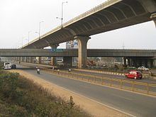
Under the bangalore electronic city flyover hosur road elevated expressway
Hosur Road Elevated Expressway (also known as Bangalore Elevated Tollway or Electronic City Flyover) is a 9.985 kilometers (6.204 mi) long elevated highway from Madiwala to Electronic City in Bangalore, India. The Bruhat Bengaluru Mahanagara Palike and Bangalore Development Authority have planned a series of flyovers and underpasses to make this arterial road signal free. The project is a part of the BETL (Bangalore Elevated Tollways Ltd), project as part of the National Highways Development Project and the Elevated Highways Project. It was initiated in early 2006, and was inaugurated on 22 January 2010. It starts from Bomanahalli after the Central Silk Board flyover and goes on up to Electronic City. It goes above the BMIC flyover on Hosur Road, at a height of 17 meters (56 ft), thus making it Bangalore's tallest flyover.
Contents
- Under the bangalore electronic city flyover hosur road elevated expressway
- Hosur road elevated expressway to silk board in peak hour traffic
- References