
Population 6,192 (2011 census) Hornsby Heights Mount Colah Postal code 2077 | Postcode(s) 2077 Area 10.3 km² | |
 | ||
Location 27 km (17 mi) from Sydney CBD | ||
Hornsby Heights is a suburb of northern Sydney, in the state of New South Wales, Australia. Hornsby Heights is located 27 kilometres north-west of the Sydney central business district, in the local government area of Hornsby Shire and is part of the North Sydney region.
Contents
- Map of Hornsby Heights NSW 2077 Australia
- History
- Population
- Parks
- Transport
- Buses
- Cycling
- Schools
- Churches
- Clubs
- Community groups
- References
Map of Hornsby Heights NSW 2077, Australia
Hornsby Heights lies to the north of Hornsby. The suburb's northern boundary and western boundary are defined by Berowra Creek, as far south as Galston Road. South of Galston Road, the western boundary, falls generally west of Berowra Creek. Walls Gully forms the eastern boundary. The southern boundary of Hornsby Heights is north of the Hookhams Corner locality. The following localities are in Hornsby Heights: Black Ash, Outlook, Galston Gorge, Montview, Somerville, Rofe Park.
History
The name Hornsby is derived from Convict-turned-Constable Samuel Henry Horne, who took part in the apprehension of bushrangers Dalton and MacNamara on 22 June 1830. In return he was granted land which he named Hornsby Place.
Population
At the 2011 census, there were 6,192 residents in Hornsby Heights. The majority of people were born in Australia and the most common ancestries were English, Australian and Irish. The median weekly household income was high at $2,053. Most dwellings were separate houses and these tended to be large, with 50.9% having 4 or more bedrooms. Home ownership was popular, with 38.8% of people owning their home outright and 51.3% paying off a mortgage. The median monthly mortgage payment was $2,383 and this was higher than the national figure of $1,800.
Parks
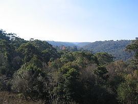
Hornsby Heights is dominated by parks. The suburb is encircled by the Berowra Valley Regional Park. Parks within Hornsby Heights are Rofe Park and Montview Oval. Rofe Park is located on Galston Road and has a leash-free dog area. Crosslands Reserve, a camping and picnic area is at the northern end of Hornsby Heights. Hornsby Heights also contains small parks such as Ulolo, off Galston Road, and Leonora Close Park, off Sommerville Road. Many of these can be found around various quiet streets.
The Galston Gorge to Crosslands section of the Great North Walk runs along the western boundary of Hornsby Heights.
Transport
At the 2011 census, 20.3% of employed people travelled to work on public transport and 58.6% by car (either as driver or as passenger).
Buses
Hornsby Heights is serviced by bus route number 596, operated by Transdev NSW. The bus runs in a loop from Hornsby railway station. The loop takes in Galston Road, Somerville Road and the area around Montview Oval (Montview Parade and McKay Road). On a weekday the buses run between the approximate hours of 6am and 9pm. A reduced service operates on weekends and public holidays.
Cycling
A cycling track exists along Galston Road, starting at Hookhams Corner and ending at Rofe Crescent.
Schools
Schools in Hornsby Heights include Hornsby Heights Public School and Hornsby North Public School. Hornsby North Public School sits on the boundary between Hornsby and Hornsby Heights. Hornsby Heights Public School celebrated its 50th birthday in 2011.
Churches
Saint Luke's Anglican Church is located at 155 Galston Road.
Hornsby Heights lies within the Ku-ring-gai Chase Catholic parish.
Hornsby Heights Baptist Church is at 110A Galston Road, next to the shopping centre.
Clubs
Hornsby Heights Sports Club
1st Hornsby Heights Scout Group
St Luke's Railway Modellers Club
Community groups
The NSW Rural Fire Service's control centre for the Hornsby – Ku-ring-gai region is located at 143 Galston Road in Hornsby Heights.