
Province Antártica Elevation 425 m | ||
 | ||
Adjacent bodies of water Pacific ocean / Atlantic ocean | ||
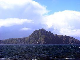
3g9ja hornos island tierra del fuego archipelago from dxnews com
Hornos Island (Spanish: Isla Hornos) is a Chilean island at the southern tip of South America. The island is mostly known for being the location of Cape Horn. It is generally considered South America's southernmost island, but the Diego Ramírez Islands are farther south. The island is one of the Hermite Islands, part of the Tierra del Fuego archipelago.
Contents
- 3g9ja hornos island tierra del fuego archipelago from dxnews com
- Map of Hornos Island Magallanes y la AntC3A1rtica Chilena Region Chile
- Geology
- Climate
- References
Map of Hornos Island, Magallanes y la Ant%C3%A1rtica Chilena Region, Chile
The Chilean Navy maintains a station on the island, consisting of a residence, utility building, chapel, and lighthouse. A short distance from the main station is a memorial, including a large sculpture featuring the silhouette of an albatross, in honour of the sailors who died while attempting to "round the Horn".
The island is within the Cabo de Hornos National Park.
Geology
The composition of the island is mainly of Cretaceous granite with Jurassic volcanic rocks in the northwest. The lower areas of the island are filled with peat moss.
Climate
Mean Temperature: 5.3° Celsius
Maximum Temperature: 20.5° Celsius (February 1996)
Minimum Temperature: -14.5° Celsius (June 1992)
Mean Relative humidity: 86.4%
Mean Wind Direction: 264°
Mean Wind Speed: 84 knots
Maximum Wind Speed: 119 knots (August 1995)
Rainfall (yearly mean): 697.5 mm.
Maximum Rainfall: 1263.2 (1990)