
Population 730 (2011) Civil parish Hornby-with-Farleton Dialling code 015242 | OS grid reference SD584684 Sovereign state United Kingdom | |
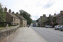 | ||
Hornby-with-Farleton is a civil parish in the City of Lancaster in Lancashire, England. It had a population of 729 recorded in the 2001 census,. increasing marginally to 730 at the 2011 Census. The parish is about 8.5 miles (13.7 km) north-east of Lancaster and consists of two villages: Hornby and Farleton, both on the A683 road.
Contents
Map of Hornby, Lancaster, UK
Hornby
Hornby is situated close to where the River Wenning joins the River Lune. In the centre of the village is St Margaret's Church with its octagonal tower. A mile to the north are the earthwork remains of Castle Stede, a motte-and-bailey castle dating from the eleventh or twelfth century.
Hornby Castle overlooks the village. It was started in the 13th century as a replacement for Castle Stede. The tower is 16th century but the rest was constructed during the 18th and 19th centuries. Despite the castle now being divided into flats, it is still one of the most recognisable points of the village. Hornby Castle and grounds are private, although the gardens are open two weekends each year in February for snowdrops and May with a small entrance fee. There is no access to castle buildings, but most of the grounds are available to walk round freely on these dates. The gardens also feature a walled garden with plants for sale.
Farleton
Farleton is the south of the main A683 road.
The Toll House, a Grade II listed building was, in the 1920s, a garage.