
Population 292 (2011) Civil parish Hordley Local time Tuesday 6:04 PM | OS grid reference SJ379308 Dialling code 01691 | |
 | ||
Weather 12°C, Wind W at 10 km/h, 78% Humidity | ||
Hordley is a small and rural village and civil parish in North Shropshire, Shropshire, England. The population of this Civil Parish at the 2011 census was 292.
Contents
Map of Hordley, Ellesmere, UK
It lies a few miles south of Ellesmere.
Etymology
Hordley takes its name from the Hoord Family of whom Henry de Hoord (c.1170) is the first recorded member.
"'In 1215, King John confirms to the Prior and Monks of Durham a gift which Henry de Hoord made to them.'
It is thought that the name itself is of Scandinavian origin, there being a family name of Hord in Sweden. Furthermore, the arms of the Hoord family includes a raven, commonly associated with the Norse invaders of the time.
History
The original medieval manor is thought to have occupied the site where today stands Hordley Manor, a much later building. Some stonework in the cellar of the current building is thought to date from the original building.
Sir Roger Kynaston (c.1433 - 1495), founded the Kynaston of Hordley line. The Kynastons were lords of the manor for a time, and later Kynaston graves can be seen in Hordley Church.
Within the parish boundaries is another small village - Bagley.
Agriculture
Hordley is set down to mainly arable crops, with some dairy farming. Towards the Lower Hordley end of the village is the factory of ABP, an abattoir which prepares, matures and packages beef.
Towards the west, there are attractive views of many hills. The River Perry runs through it, joining the River Severn into Shrewsbury. It is generally a quiet, rural area.
Within reach of this village are many easily accessible towns, including Ellesmere, Oswestry and Shrewsbury.
On one day there is a post office set up in the village hall.
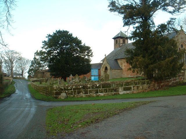
It is usually taken that the village is split into two parts, Top and Lower Hordley. This is probably because of the long distance of road separating the two halves with nothing but field either side. Within the upper part there is St. Marys Church which is still in regular use, surrounding this is a small area of grave yards. There is also a farm and some small clusters of housing. Within Lower Hordley is a larger quantity of housing and farms, and the village hall.
The Weston Lullingfields branch of the Ellesmere Canal passed around Top Hordley and through Lower Hordley until its closure in 1917.