
Time zone Eastern (EST) (UTC-5) Local time Tuesday 12:04 PM | Population 8,188 (2010) Area code 401 | |
 | ||
ZIP codes Weather 2°C, Wind SW at 42 km/h, 89% Humidity Area 114.2 km² (111.4 km² Land / 2.849 km² Water) Neighborhoods Hope Valley, Ashaway, Kierieian, Rhode Island | ||
Hopkinton is a town in Washington County, Rhode Island, United States. The population was 8,188 at the 2010 census.
Contents
- Map of Hopkinton RI USA
- History
- Geography
- Villages
- Demographics
- Politics
- Notable people
- National Historic Places
- References
Map of Hopkinton, RI, USA
History
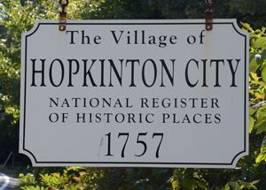
Hopkinton is named after Stephen Hopkins, a signer of the Declaration of Independence who was Governor of the Colony of Rhode Island and Providence Plantations when the town was partitioned from Westerly and incorporated in 1757. Hopkinton once featured a number of industrial villages, such as Locustville, Moscow, Centerville, and Wood River Iron Works, each being named after the mill which they surrounded. Today only Hope Valley, Rockville, Ashaway, and Bradford are recognized with a post office. A section of the town has its own post office known as simply "Hopkinton." The town hall is located in the village of Hopkinton City, which was once a major stagecoach hub..
Geography
Hopkinton is found at 41.461 N latitude and 71.778 W longitude and borders Richmond and Charlestown. It is on the Pawcatuck River on the Connecticut border.
According to the United States Census Bureau, the town has a total area of 44.1 square miles (114 km2), of which, 43.0 square miles (111 km2) of it is land and 1.1 square miles (2.8 km2) of it (2.58%) is water.
Hopkinton is the southernmost town along Rhode Island's portion of Interstate 95; as such it is the first Rhode Island town that northbound travelers encounter.
Villages
In Hopkinton, the two primary villages are Hope Valley in the north and Ashaway in the south. Two of the four elementary schools in the Chariho Regional School District are located in Hopkinton: one in Hope Valley and one in Ashaway. Other villages that are located (or partially located) in Hopkinton include Barberville, Bethel, Bradford, Burdickville, Canonchet, Centerville, Hopkinton City, Locustville, Moscow, Rockville, South Hopkinton, Woodville and Yawgoog. Almost all of these villages formed from mills on rivers. Some villages dominate others when it comes to postal addresses, home identification and where to attend school. As before mentioned, the two most dominant villages are Hope Valley and Ashaway, which have extended their borders as census-designated places into other less-known villages.
Demographics
As of the census of 2000, there were 7,836 people, 2,965 households, and 2,182 families residing in the town. There were 3,112 housing units at an average density of 72.4 per square mile (27.9/km²). The racial makeup of the town was 96.82% White, 0.61% African American, 0.89% Native American, 0.43% Asian, 0.27% from other races, and 0.97% from two or more races. Hispanic or Latino of any race were 1.06% of the population.
There were 2,965 households out of which 35.2% had children under the age of 18 living with them, 61.9% were married couples living together, 7.7% had a female householder with no husband present, and 26.4% were non-families. 21.0% of all households were made up of individuals and 9.4% had someone living alone who was 65 years of age or older. The average household size was 2.64 and the average family size was 3.07.
In the town, the population was spread out with 25.7% under the age of 18, 6.4% from 18 to 24, 31.6% from 25 to 44, 25.4% from 45 to 64, and 11.1% who were 65 years of age or older. The median age was 38 years. For every 100 females there were 99.7 males. For every 100 females age 18 and over, there were 96.9 males.
The median income for a household in the town was $52,181, and the median income for a family was $59,143. Males had a median income of $39,804 versus $29,189 for females. The per capita income for the town was $23,835. About 3.3% of families and 4.8% of the population were below the poverty line, including 5.5% of those under age 18 and 7.2% of those age 65 or over.
Students in Hopkinton are part of the Chariho Regional School District.
Politics
In the state legislature Hopkinton is located in the 34th Senate District, represented by Republican Francis T. Maher, Jr, and in the 38th District in the Rhode Island House of Representatives by Democrat Brian Patrick Kennedy. At the Federal level, Hopkinton is located in Rhode Island's 2nd Congressional District, which is currently represented by James Langevin (D). In the United States Senate, Hopkinton is represented by U.S. Senator John F. Reed (D) and U.S. Senator Sheldon Whitehouse (D).
Notable people
The Aldrich and the Rockefeller families each built small mansions in Hope Valley region of Hopkinton before the families merged. The Rockefeller house now serves as the rectory for St. Joseph's Parish.