
Elevation 356 m | Parent range Lake District | |
 | ||
Similar | ||
The honister pass britain s best driving road
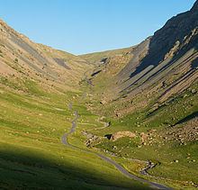
The Honister Pass is a mountain pass in the English Lake District. It is located on the B5289 road, linking Seatoller, in the valley of Borrowdale, to Gatesgarth at the southern end of Buttermere. The pass reaches an altitude of 1,167 feet (356 m), making it one of the highest in the region, and also one of the steepest, with gradients of up to 1-in-4 (25%). The saddle at the watershed is known as Honister Hause, using the Cumbrian word hause for such a feature.
Contents
- The honister pass britain s best driving road
- Map of Honister Pass Keswick UK
- Honister pass england best lake district scenic road on bmw r1200gs motorbike
- References
Map of Honister Pass, Keswick, UK
The Honister Pass is one of three passes that link the tourist area around Keswick, including Derwent Water and Borrowdale, with the valley of the River Cocker, including the lakes of Buttermere, Crummock Water and Loweswater. From north to south these passes are the Whinlatter Pass, the Newlands Pass, and the Honister Pass.
The Honister Slate Mine and Honister Hause Youth Hostel are located at the summit of the pass.
Footpaths lead from the summit of the pass to Fleetwith Pike to the west, Grey Knotts to the south, and Dale Head to the north.
Honister Pass holds the UK 24-hour rainfall record; in the 24 hours to 6 pm on 5th December 2015, 341.4 mm of rain fell there.