
- Tree Sakura Population 47,396 (Sep 2015) Bird Japanese bush warbler | Region Kantō - Flower Sunflower Area 207.6 km² Local time Monday 6:12 PM | |
 | ||
Weather 8°C, Wind E at 14 km/h, 81% Humidity | ||
Hokota (鉾田市, Hokota-shi) is a city located in Ibaraki Prefecture, in the northern Kantō region of Japan. As of September 2015, the city had an estimated population of 47,396 and a population density of 228 persons per km². Its total area was 207.61 square kilometres (80.16 sq mi).
Contents
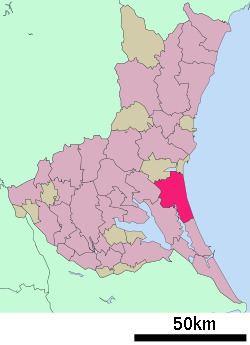
- Map of Hokota Ibaraki Prefecture Japan
- Geography
- Surrounding municipalities
- History
- Economy
- Education
- Railway
- Highway
- Local attractions
- Notable people from Hokota
- References
Map of Hokota, Ibaraki Prefecture, Japan
Geography
Hokota is located in central Ibaraki Prefecture, bordered by the Pacific Ocean to the east. It is approximately 90 kilometers northeast of Tokyo.
Surrounding municipalities
History
The town of Hokota was created with the establishment of the municipalities system on April 1, 1889. The city of Hokota was established on October 11, 2005, from the merger of the former town of Hokota, and the villages of Asahi and Taiyō (all from Kashima District).
Economy
The economy of Hokota is primarily agricultural, with melons as a major cash crop.