
State/Province DE-NW Elevation 500 m | Range Ahr Hills (Ahr Eifel) | |
 | ||
Similar Scharteberg, Michelsberg, Rockeskyller Kopf, Hochsimmer, Nerother Kopf | ||
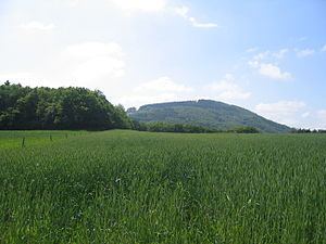
The Hochthürmerberg (variously also called the Hochthürmchen, Hochthürmen or Hochthürmer), is a hill, 499.9 m above sea level (NHN), in the Eifel region. It is situated in the county of Euskirchen in North Rhine-Westphalia near the state border with Rhineland-Palatinate in Deutschland.
Contents
- Map of HochthC3BCrmerberg 53902 Bad MC3BCnstereifel Germany
- Location
- Summit and viewing points
- References
Map of Hochth%C3%BCrmerberg, 53902 Bad M%C3%BCnstereifel, Germany
Location
The Hochthürmerberg is located within the Ahr Hills (Ahr Eifel) south of the village of Houverath in the county of Euskirchen ni North Rhine-Westphalia and northeast of the village of Kirchsahr in the county of Ahrweiler in Rhineland-Palatinate. The state border runs roughly along the 440-metre contour line over the southern flank of the hill. The Hochthürmerberg's neighbouring hill is the Hasenberg.
Summit and viewing points
At the summit are the remains of a circular rampart. The summit dome is wooded and offers no views at all. However, from a section of the Ahr-Fen Way, which is located between Kirchsahr and Krälingen, there are views of the Hohe Acht, the Michelsberg, the Nürburg and even the Scharteberg and Döhmberg. Near Krälingen there is a good view of the region of the Middle and Lower Ahr; nearby rise the hills of Krausberg, Neuenahrer Berg and the neighbouring Hasenberg.