
 | ||
The territorial dispute between Ecuador and Peru was the source of the longest-running international armed conflict in the Western Hemisphere. This dispute was a consequence of each countries interpretation of what Real Cedulas (Royal Proclamations) Spain used to precisely define its colonial territories in the Americas. After independence all of Spain's colonial territories signed and agreed to proclaim their limits in the basis of the principle uti possidetis juris which accepts the Spanish colonial borders of 1810 as the borders of the new republics. Thus the borders of Gran Colombia which included Ecuador, Colombia and Venezuela would follow the borders of the Viceroyalty of New Granada, and Peru the Viceroyalty of Peru in 1810. However, Peru was not satisfied with this and tried to set the date of her Uti Possitedis to 1824- a time when Peru was officially independent with territories Peru militarily occupied since 1820. Tumbes and Jaen de Bracamoros, to which Peru had no colonial titles, were territories that declared their independence in 1820 and were militarily occupied by Peruvian patriot forces that convinced the people in these territories to join Peru. Because of this, Peru claims that part of its western territorial borders where it lacks title is derived from free determination of its people in the border areas after independence. In the eastern section known as Maynas or Mainas, which was the sparsely inhabited and entirely Amazon Basin, Peru basis its legal claims on the disputed Real Cedula of 1802. Gran Colombia which declared independence 2 years earlier in 1819 and helped to liberate Peru in the Battle of Junin and Ayacucho basis its rights on the clear and undisputed Real Cedulas of 1717, 1739 and 1740 and declares that the Real Cedula of 1802 is not political in nature, but was meant only for ecclessiastical and military jurisdiction.
Contents
- Spanish conquest and establishment of the Viceroyalty of Peru
- Territorial division of the Viceroyalty of Peru
- Creation of the Viceroyalty of New Granada
- Real Cedula of 1802
- 18031818
- Independence from Spain
- The Gran ColombiaPeru War
- Confusion about Gran Colombia
- The Pedemonte Mosquera Protocol
- 18321856
- The EcuadorianPeruvian territorial dispute of 18571860
- 18601941
- The EcuadorianPeruvian War
- Rio de Janeiro Protocol
- Ecuadors objections to the Protocol and thesis of Nullity
- The Paquisha Incident 1981
- The Cenepa War 1995
- 19951998 Arbitration and final resolution
- Political social and economic impact
- Education and public perception
- Economic impact
- Political implications
- References
During the first 10 years of independence, Gran Colombia under the leadership of Simon Bolivar had continually protested Peru's occupation of Tumbes and Jaen; Maynas had not been militarily occupied yet. When Peru ignored Simon Bolivars ultimatum which was return to return Tumbes and Jaen or face war Peru ignored this. Simon Bolivar then declared war and Peru began the war by successfully invaded and occupied southern Ecuador with a force of 8,000 soldiers. Simon Bolivar sent Jose Antonio de Sucre to Ecuador who lead 4,000 Gran Colombian soldiers that defeated the Peruvian invaders in the Battle of Tarqui in 1829. The Treaty of Giron ended the war and the Treaty of Guayaquil in 1829 more or less restated the borders of Uti Possidetis juris of 1810 with slight modification in favour of Peru to form a clear border. Negotiations began known as protocolized conferences where Gran Colombia ceded some of its territory for the sake of peace and to have river borders to avoid future disputes. During these conferences both parties agreed that in the west the borders should follow the rivers Tumbes, but that either the Huancabamba or the Chinchipe would be decided later. In the east both agreed to divide Maynas in half and that both republics would be separated entirely by the Marañón and Amazon rivers until the border reaches Brazil. On August 10, 1830 a treaty was signed known as the Protocolo de Mosquera-Pedimonte which summarized the results of the protocolized conferences. This treaty was to end the border conflict once and for all, however, Ecuador split from Gran Colombia and thus the ones who signed the treaty did not have any negotiating powers. When Peru found out that Ecuador had seceded from Gran Colombia it decided to retain Jaen and Tumbes in the west and to slowly invade the Amazon Basin north of the Marañón river.
When the Republic of Ecuador proclaimed its secession from Gran Colombia in 1830 its government negotiated a swap of territories in the Amazon basin for debt with the British creditors, and the dispute over the territories re-ignited in 1857. Peru implemented a maritime blockade of the port of Guayaquil demanding a revocation of the deal, as well as an acknowledgment of Peruvian sovereignty over the disputed territories. These demands went unheeded and with Ecuador in a state of civil war, the government of Guillermo Franco in the province of Guayaquil, claiming to represent the entire country, agreed to Peru's demands and signed the Treaty of Mapasingue of 1860. Gabriel García Moreno's provisional government won the civil war later that year, and voided this treaty, with the new Peruvian government following suit several years later.
The dispute continued through the late 19th century and beginning of the 20th century. Numerous attempts were made to define the borders, but both governments could not come to an agreement acceptable to their constituencies. A war between Colombia and Peru occurred during 1932 and 1933 in the Eastern region of the Amazon territories and resulted in the official designation of the Putumayo River as a border between Colombia and Peru; but sectors of the society considered this detrimental to the Ecuadorian cause, with Colombia now recognizing Peru's rights to the territory that Ecuador claimed as its own. An agreement recognizing territories in de facto possession by each country was signed in 1936, but minor military skirmishes began to occur in 1938. Tensions escalated, and war broke out in July 1941, and officially came to an end with the signing of the Rio de Janeiro Protocol on January 29, 1942. The treaty was intended to finally bring the long-running territorial dispute to an end, but in 1960 the then president of Ecuador Dr. José Mª Velasco Ibarra proposed to the Congress a thesis of nullity based in the fact that the 1942 protocol was forced upon the Ecuadorian government under duress.
A brief military clash took place in early 1981, when the Peruvian Army forcefully took control of three Ecuadorian military outposts on the eastern slopes of the Cordillera del Cóndor mountain range. An agreement in 1992 between the presidents of the two countries promised to seek peaceful resolution to the conflict. However, in December 1994, the Ecuadorian army was seen to be mobilizing in the vicinity of the Cordillera del Cóndor. On January 26, 1995, war broke out over control of several outposts located on the headwaters of the Cenepa River, within a 78-kilometer strip of territory that both countries claimed as their own. In this case, the result was favorable for Peru who succeeded in taking all the Ecuadorian outposts set in Peruvian territory, although Ecuador caused some casualties. The fighting came to an end after just over one month, with the signing of the Montevideo Declaration on February 28, and the later signing of the Itamaraty Peace Declaration under the supervision of the guarantors of the Rio Protocol of 1942: Argentina, Brazil, Chile, and the U.S.
Tensions subsided but persisted over the next three years. On October 26, 1998, Ecuador and Peru signed a comprehensive peace accord that established a framework for ending a border dispute. Formal demarcation of border regions started on May 13, 1999. The agreement was ratified without opposition by the congresses of both nations, finally bringing an end to the dispute, almost two centuries after the South American nations (or their predecessors) claimed their independence from the Spanish Crown.
Spanish conquest and establishment of the Viceroyalty of Peru
Beginning with the arrival of Christopher Columbus in 1492, the Spanish conquistadores expanded the range of the Spanish Crown's reach from early small settlements in the Caribbean to various continental territories, eventually including Central America and most of South America.
The Spaniards arrived at the borders of the Inca Empire in 1528, and on November 16, 1532, taking advantage of the Inca Civil War, the tiny army of Francisco Pizarro began the Spanish conquest of Peru. In the following decades, Spain consolidated its power over the entire Andean region, repressing successive indigenous rebellions.
To govern the new territories of Spain, in 1542 Holy Roman Emperor Charles V (King Charles I of Spain) created two Viceroyalties, the Viceroyalty of New Spain (in modern-day Mexico) and the Viceroyalty of Peru (a.k.a. the Viceroyalty of New Castile). In 1542, King Charles named Blasco Núñez Vela Peru's first viceroy, but the viceroyalty was not organized until the arrival of Viceroy Francisco de Toledo in 1572. Toledo promptly declared war on Vilcabamba, the last refuge of the Inca; soon afterwards, Tupac Amaru, the last Inca emperor, was captured and executed in Cuzco.
Territorial division of the Viceroyalty of Peru
Because the territory of the Viceroyalty of Peru was so large, and far away from centers of government in Lima and Santo Domingo, Peru (as well as New Spain) was divided into a number of real audiencias (royal audiences), a type of superior judicial tribunal that combined executive and judicial authority, and can be considered "major provinces". The audiences controlled the gobernaciones, alcaldias mayores, corregimientos, and alcaldias ordinarias. The territory was also divided ecclesiastically, into archbishoprics, religious provinces, suggragan bishopries, parishes and curateships. The archbishoprics and religious provinces corresponded with the audiences, the bishoprics with the gobernaciones and alcaldias mayores, and the parishes and curateships with the corregimientos and alcaldias ordinarias.
These civil divisions were not uniform, with numerous exceptions being made based on the specific circumstances. The Viceroys were presidents of the audiences at the capitals of their Viceroyalties, with other audiences being presided over by captains-generals, or by persons known as gowned presidents. Power was devolved to the captains-general of an audience by the Viceroy, and the audience's territory was administered by the audience's president and the political, military, and religious officials underneath him.
Between 1542 and 1717, the Viceroyalty controlled most of the territory of South America (save for a few non-Spanish colonies and the Commandancy General of Caracas, which was a dependency of the Captaincy General of Santo Domingo). The territory was divided among (noting dates of creation):
- Royal Audience of Tierra Firme (1564)
- Royal Audience of Santa Fe de Bogotá (1548)
- Royal Audience of San Francisco of Quito (1563)
- Royal Audience of the City of Kings Lima (1543)
- Royal Audience of La Plata de los Charcas (1559)
- Royal Audience of Chile (1563–1573; 1606, sometimes referred to as the Kingdom of Chile)
The district of an audience was established in the royal decree by which it was created; the laws laid out in the myriad of Cédulas Reales issued by the Spanish Crown were compiled several times throughout the centuries-long history of Spanish presence in the region. These compilations were referred to as the Laws of the Indies; the 1680 compilation, organized under Charles II, known as the Recopilación de las Leyes de los Reynos de Indias (Compilation of the Laws of the Kingdoms of the Indies), set a template by which the laws were organized.
Under Title XV of Book II of the Recopilación, the limits of the audiences of Lima and Quito were defined as follows:
Creation of the Viceroyalty of New Granada
The two original Spanish viceroyalties of New Spain and Peru had existed intact up until 1717, when King Philip V of Spain issued the Real Cédula of May 27, 1717. The order split off the northwestern corner of Peru and created the Viceroyalty of New Granada. New Granada shared its capital with the Royal Audience of Santa Fé de Bogotá, and additionally had jurisdiction over the New Kingdom of Granada, as well as the audiences of Tierra Firme (now called Panama), Quito, and the Captaincy General of Venezuela. The territories of the Viceroyalty comprised the territories of, respectively, the modern Republics of Colombia, Ecuador, Panama, and Venezuela, as well as the northern regions of Peru, the Brazilian northwest, and the western part of Guyana.
The Royal Audience of Quito had been established by a royal decree in 1563, its territory including Pasto, Popayán, Cali, Buenaventura and Buga in what is currently Colombia, and extended as far south as Piura in what is now Peru. The eastern limit was ill-defined at the time, due to a lack of geographical knowledge and the low importance given to unpopulated, hard-to-reach territories. As the Jesuits Missionaries from Quito and other missionaries entered the Amazaon Basin the Amazon region with its tributaries were more clearly defined and by 1740 the Real Cedula de 1740 precisely defined the borders between the Viceroyalties of New Granada and Peru.
Having temporarily suppressed the Viceroyalty of New Granada, on November 5, 1723, Philip V emitted another Cédula, which returned control of the Royal Audience of Quito to the Viceroyalty of Peru. The Cédula of August 20, 1739 (also called the Cédula de Reerección Definitiva del Virreinato de Nueva Granada, "Definitive Decree of Re-erection of the Viceroyalty of New Granada") reinstated the viceroyalty with its 1717 territories, including the Royal Audience of Quito. The border between Quito and the Viceroyalty of Peru was defined in 1740 by another Cédula:
Starting from the Tumbes on the Pacific Coast, the line follows by the ridges and other cordilleras of the Andes through the jurisdiction of Paita, and Piura to the Marañón, at 6 degrees, 30 minutes South Latitude, and on the interior, leaving to Peru the jurisdiction of Piura, Cajamarca, Moyobamba and Motilones; and by the cordillera of Jeveros, crossing the river Ucayali, at 6 degrees of South Latitude, up to the Javary River or Jauri River at its confluence with the Carpi; and on the waters of the latter to Solimões or the Amazonas and from thence down to the most westernly mouth of the Caquetá or Yapurá, where the boundaries with Brazil begin."
This cedula greatly modified the original demarcation, but served only to fix the starting point of the line on the pacific coast at the river Tumbes. This document was the first mention of the Tumbes as the boundary between the two viceroyalties.
Real Cedula of 1802
Don Francisco de Requena requested that control of the Government and Commandancy General of Maynas pass from the Viceroyalty of Santa Fe (New Granada) to the Viceroyalty of Peru. In response, on July 15, 1802, the Spanish crown under the rule of Charles IV of Spain issued the Real Cédula of 1802. The decree split the Government and Commandancy General of Maynas and the Government of Quijos from the Audience of Quito, and added them to the Viceroyalty of Peru. The text of the decree, as reproduced in the Annals of the diplomatic and consular missions of Colombia (1901), reads:
I have resolved that the administration and General Command of Maynas with the towns of the administration of Quijos be separated from the province of Quito and added to the Viceroyalty of Santa Fe, except for Papallacta, for reason that they are all on the shores of the Napo River or its immediacies, extending the aforementioned General Command not only downstream of the Marañón River, to the borders of the Portuguese colonies, but also down all the other rivers entering the Marañón by its northern and southern margins as do the Morona, Huallaga, Paztaza, Ucayali, Napo, Javari, Putumayo, Japurá, and other less significant, until the place in which these cease to be navigable streams: the villages of Lamas and Moyobamba must also become part of the aforementioned General Command... To which end I order that you aid, added as is the administration of Maynas and Quijos to this Viceroyalty, with whatever steps you deem necessary, and I request of you, the Commander General, that you serve them not only for the advancement and conservation of the peoples in the custody of the missionaries, but also for the security of my dominions, by preventing them from being brought forward by the vassals of the Portuguese Crown, by naming the junior sergeants or Lieutenant Governor that you see fit, for the defense of these frontiers and the administration of justice... I have also resolved to erect a diocese in said missions... I THE KING
In a footnote, Dr. Antonio José Uribe, Minister of Foreign Affairs of Colombia from 1901 to 1902, wrote,
With respect to this Real Cédula of 1802, it is worth noting that there are three specimens available, all of them Peruvian in origin, and not one of them agrees with any of the others, they are: the one produced by Dr. [Enrique Vacas] Galindo; the one contained in the volume published in Brazil; and the one in the Peruvian brief presented before the Government of Spain in the matter of the limits with Ecuador.
thereby casting suspicion on the authenticity of one or more of the copies of the document, complicating the already difficult matter of interpreting its meaning.
According to Pedro Moncayo y Esparza, a 19th-century Ecuadorian writer, the Viceroy of Santa Fe and the President of Quito objected to the execution of the Real Cédula of 1802, as it had all the makings of an apocryphal document: it was not registered in the official cedulario, and its contents could not be found in the Recopilacion de Indias, nor had it been located in the Archive of the Indies in Spain. However, during the Peruvian congressional committee hearings regarding the dismissal of the Treaty of Mapasingue, signed between Ecuador and Peru at the end of the dispute of 1857-1860, it was stated that the Real Cédula of 1802 and the documents proving its execution were found in the archives of the ancient government of Maynas.
The lack of clarity within the document as to whether the transfer of administrative power was purely military and ecclesiasticcal in nature, or territorial as well, formed the basis for an imprecise territorial situation between Ecuador and Peru when the two nations obtained their independence from Spain.
1803–1818
Independence from Spain
The Republic of Gran Colombia was founded in 1819, with Simón Bolívar as President. On August 7 of that year, the independence of what is now Colombia was won in the Battle of Boyacá. The independence of Venezuela was won on June 24, 1821 in the Battle of Carabobo. One of Bolivar's generals, Venezuelan-born General Antonio José de Sucre won the Battle of Pichincha on May 24, 1822 and freed the territory that was then Ecuador.
Gran Colombia comprised what is now Colombia, Ecuador, Venezuela and Panama. It was Simón Bolivar's dream to unite all of South America, a project which he would never achieve.
Even before the battles for the freedom of the South American colonies were over, Bolivar established the uti possidetis juris principle as the basis for the territorial demarcation of the new nation-states that were to be born out of the ancient colonial jurisdictions. In essence, the principle stated that the borders of the new countries should correspond to the Spanish administrative borders, as they were in 1809. This would present some difficulties due to lack of geographical knowledge, and also because much of the territory was unpopulated and unexplored. By this principle, the territory of the Viceroyalty of Peru would become part of Peru, and the territory of the Viceroyalty of New Granada part of Gran Colombia.
The Gran Colombia–Peru War
Bolivar had aspirations to be president for life of Gran Colombia, a republic that would unite most of the former Spanish colonies under his rule. Peruvian President José de la Mar, who had been a member of Bolivar's troops during the wars of independence and born in Cuenca, Ecuador, had his own political ambition: to establish himself as the formal ruler of Peru. As a result, relations between Bolivar and De la Mar quickly cooled, and the two soon became rivals. Bolivar's promotion of Antonio José de Sucre to "Mariscal" (marshal), which made him his personal war assistant, particularly angered De la Mar, who officially became Bolivar's enemy.
Deciding to free Peru (what is now Peru and Bolivia) from what he considered to be an authoritarian project, De la Mar promoted an anti-Bolivarian campaign which gained popular support and led to insurrections, both in Peru and in Bolivia (Alto Perú), where the Colombian Army was expelled. Finally, he decided to confront Bolivar more directly by launching an attack. On June 3, 1828, de la Mar invaded the southern region of Gran Columbia; he occupied Loja and tried to capture Guayas, and intended to annex those territories to Peru.
Furious upon hearing the news, Simón Bolívar resolved to declare war against Peru. Sucre was appointed Commander of the Colombian Army. In 1829, De la Mar and General Agustin Gamarra occupied Cuenca, but were defeated in what is known as the Battle of Portete de Tarqui (also known as the Battle of Tarqui) by Sucre on February 27, 1829. A coup supported by General Gamarra in the Peruvian Army against President De la Mar paved the way for a peace treaty. Subsequently, the Convenio de Girón between Peru and Gran Colombia recognizes as borders the "same ones of the corresponding Viceroyalties before independence." On July 10, the Piura Armistice recognised the annexation of Guayaquil to Gran Colombia, and on September 22, the war between Peru and Gran Colombia formally ended. [4]
The Gran Colombia federation dissolved during 1830 because of political struggles between regions which strengthened after Bolivar's resignation. Ecuador was born as a country on May 13, 1830 and began its separate existence with the adoption of a Constitution on September 23, 1830. According to this constitution, the Republic of Ecuador was composed of the provinces of Azuay, Guayas and Quito. These provinces later divided into the many provinces that exist today in Ecuador.
Confusion about Gran Colombia
The term Gran Colombia is used today to refer to the federation that was formed between the Republics of Ecuador, Colombia (with Panama) and Venezuela before 1830. However, Gran Colombia is an anachronistic term, as the country was simply referred to as Colombia, which is clear, for example, by looking at original documentation of the many treaties signed between Colombia and Peru before 1830.
In Peru, the dissolution of Gran Colombia is seen as a country ceasing to exist, giving way to the formation of new nation states that had nothing to do with the original federation. The significant implication of this view is that the treaties Peru had signed with Gran Colombia were voided, as the country in question no longer existed, and was replaced with three new states, the Republic of the New Granada (which subsequently changed its name to Republic of Colombia), the Republic of Venezuela and the Republic of Ecuador.
An alternative view is that Ecuador and Venezuela separated from the Gran Colombia Federation (from Colombia in actuality) and inherited any treaties that Gran Colombia had signed with Peru as they applied to their corresponding territories. There are indications that Colombia itself maintained this position. On the surface, it seems far-fetched that the Republic of Colombia after 1830 is a different country from the Republic of Colombia before 1830, even though they shared a capital city, a subset of territory and much of their citizenry. Additionally, the argument that border treaties are voided when federations are dissolved does not appear to have substantial merit and is clearly conflict-prone.
The Pedemonte-Mosquera Protocol
Ecuador and Colombia maintain that the Pedemonte-Mosquea Protocol was signed in Lima on August 11, 1830 by Peru and Gran Colombia as a result of the Battle of Portete de Tarqui. The protocol settled the eastern section of the disputed border from the Andes Mountains to Brazil by making the Marañón River and Amazon River the new border between the two republics. The protocol settled the western section of the border from the Andes Mountains to the Atlantic Ocean by making the Macará river and the Tumbes river the new boundary. However, it left the status of a small area in the Andes Mountains named Jaén de Bracamoros in dispute. It was decided by Pedemonte and Mosquera that on a later date, either the Chinchipe River or the Huancabamba River would be chosen as the new boundary.
Ecuador has used this protocol as primary legal support of its core claims throughout the history of the conflict. Peru has disputed the credibility and the existence of the Pedemonte-Mosquera protocol on several points:
Even though it seems unlikely that Ecuador would have concocted a historical treaty of this nature, the fact that the existence of the original document cannot be demonstrated conclusively is significant.
Ecuador has managed to produce a copy made in 1870 that the Colombian embassy in Lima sent to Bogotá. The copy in question was obtained from someone's personal collection. However, it was not certified by Peru and remains disputed.
The Mosquera-Pedemonte protocol is mentioned in a Colombian document titled Legislative Act No. 3 published October 31, 1910. [6] The document explains how the borders between Colombia and its neighbors have been established; as to its border with Peru, it indicates they are those adopted by Mosquera-Pedemonte, in development of the treaty of September 22, 1829.
There are conflicting versions of what exactly took place. For an Ecuadorian view point, see [7]. For Peruvian points of view, see [8][9].
1832–1856
March 10, 1853: Creation of the Peruvian Government of Loreto
To justify its claims to the disputed amazonian territory Peru decides to create a separate amazonian political military government naming it the Government of Loreto, after Peru successfully takes over a small amazonian port called Nauta. The policy of the Loreto Government is to concentrate on exploring, taking over, and settling these vacant areas with Peruvian citizens before Ecuador and Colombia, thus having a good de facto position if the dispute goes to arbitration. Before 1890, the fluvial armada concentrated in taking over the small river ports along the Marañón river like Nauta, Omaguas, Iquitos, Regis, Parinari, Antonio, Santander, Barrabca, Borja, Mazan, and Destacamento. Most of the exploration of the tributary rivers north of the Marañón river was conducted by a Peruvian military commander named Coronel Pedro Portillo in the early 20th century. The Peruvian fluvial armada at that time consisted of lightly armed rafts and boats with its main base in Iquitos, the capital of Loreto. In this way most of the northern tributary rivers which drained into the Marañón – Amazon river and its adjacent disputed territories were occupied by Peruvians.The Ecuadorian–Peruvian territorial dispute of 1857–1860
This was an expensive war fought over disputed territory bordering the Amazon. On September 21, 1857 Ecuador decided to adjudicate to Britain territories in the Canelos region as payment for international debt it had incurred during the war of independence. Peru immediately protested the Ecuadorian action citing the uti possidetis juris principle by which the Canelos region would belong to Peru, based on the territorial concession of 1802 to the Viceroyalty of Peru. Despite Peruvian complaints, Ecuador proceeded in its negotiations with the British. This led to an 1859 occupation and blockade of Guayaquil by President Castilla. (Ecuador at the time was undergoing a civil struggle.) On February 25, 1860, Peruvian minister Manuel Morales and his Ecuadorian counterpart, Nicolás Estrada, signed the Treaty of Mapasingue in order to end the dispute. (Mapasingue is a location near Guayaquil where Peruvian troops had been stationed.) Ecuador voided the concession of territories claimed by Peru to the British, and Peru withdrew its forces. However, the territorial situation remained unclear and was left to be resolved at a later time.
1860–1941
The Ecuadorian–Peruvian War
In 1941, the two countries went to war. As with all other such incidents, there are conflicting accounts to this day as to which side fired the first shot. Peru's version of events (notably well documented in Peruvian sources [17][18]) is that Ecuador had been making incursions into its territory since 1937 and occupied several border locations by 1940.
Given these circumstances, the President of Peru, Manuel Prado Ugarteche, ordered the formation of the North Grouping, a military unit in charge of the Northern Operational Theater, on January 11, 1941, consisting of two light divisions with three battalions each, plus four other independent battalions and three artillery batteries (one with six 105 mm guns) (Delgado).
In front of these forces, the Ecuadorian Border Security command had under its orders two Army battalions, the "Montecristi" and the "Cayambe", each one consisting of around 250 troops, armed with 7.92 mm Mauser rifles and a couple of Czech 7,92 mm ZB-26 light machine-guns, plus two Vickers-Maxim machine-guns. There was also a "Córdova" battalion, made up of around 100 troops, and a so-called "Mariscal Sucre" artillery battery, with 71 troops and no artillery pieces. In fact, the only artillery in the whole province of El Oro consisted of six Italian 65 mm mountain guns, sold to Ecuador as leftovers from the Great War, and almost without shells. These guns were never put into action. (Rodríguez, 1943).
As for anti-aircraft defenses, the Ecuadorians had only a pair of 20 mm Breda guns deployed on Puerto Bolivar, which was the only port of entry for supplies, reinforcements, and weapons to arrive to the province, by sea, from the port-city of Guayaquil. The Ecuadorian Army of 1941 had not a single warplane. (Rodríguez, 1943).
It is claimed that on Saturday, July 5, 1941 the Huaquillas unit of the Ecuadorian army invaded Peruvian territory, an action which originated a combat that extended across the entire Zarumilla front, up to a region known as Quebrada Seca.
Ecuador's version of events is that Peru's invasion was an unprovoked act of aggression carried out with the explicit purpose of forcing Ecuador to sign an unfavorable treaty that would impose the status quo border line.
A communiqué by Ecuador's Foreign Ministry indicated that Peruvian forces had been seen advancing north towards the border; all of the Peruvian troops stationed in Tumbes had left Zarumilla and those in Piura and other nearby sites were in turn advancing towards Zarumilla.
According to the Ministry, the actions of the Ecuadorian army were limited to repelling the invasion which was occurring across much of the border. [19] As support for its arguments Ecuador has repeatedly cited the obvious difference in military might between the two countries, and the lack of preparedness of its forces. It has been speculated that Peru prepared to carry out an all-out invasion and could have been simply waiting for the slightest provocation.
Ecuador has also cited Peru's history of conflict with its other neighbors as evidence of its belligerence. It has been pointed out, however, that these circumstances did not preclude Ecuador from attempting to lay claim to territories it still considered its own. Also, during the War of the Pacific, Ecuador military occupied a portion of the disputed territories.
The much larger and better equipped Peruvian force of 13,000 men quickly overwhelmed the 1,800 Ecuadorian troops guarding the province of El Oro. The Peruvian army had at its disposal a battalion of armor made up of Czech tanks LTP, with artillery and air support. (Beginning with the second third of the 20th century, Peru allegedly has one of the strongest military forces in South America, even as recently as 2005 ranked second after Brazil and stronger than Argentina [20]).
The Ecuadorian president, Carlos Arroyo del Río, kept Ecuador's best forces in Quito, for fear of his political opponents (Arroyo would later resign on May 31, 1944 after much unrest in the country). Peru carried out the first use of paratroops in combat in the Western Hemisphere, dropping three paratroopers over the port-city of Puerto Bolívar (Delgado), one of them having been rescued by Ecuadorian fishermen when he landed on the waters of the Jambelí channel.
This attempt was largely successful in allowing a relatively easy takeover of El Oro towns, devoid by then of any Ecuadorian military presence after the short-lived ceasefire of July 26, brokered by the mediator countries (USA, Brazil and Argentina). After the ceasefire, most of the Ecuadorian troops, by now exhausted and without ammunition, left the field of battle and made their way out of El Oro, towards the city of Cuenca.
Thus, when Peru reopened the advance on July 29, which began with simultaneous bombings on the Ecuadorian towns of Machala, Puerto Bolívar, Pasaje, Santa Rosa, and Arenillas, plus a mission to the city of Guayaquil to drop leaflets, the Peruvian forces easily occupied the deserted towns of the province. A new ceasefire having been decreed to enter in effect on July 31 at 18h00 forced the Peruvian command to step up its efforts to occupy Machala and Puerto Bolívar, which they did with troops disembarked directly on Puerto Bolívar from the sea in the afternoon of July 31. (Delgado)
Even then, hostilities didn't cease, as Peruvian forces began operations against the Ecuadorian posts on the Amazonian jungle, most of which were easily overrun.
With Peru occupying El Oro and menacing Guayaquil, plus pressure from the United States and Latin America to stop the hostilities as a sign of hemispheric unity against the Axis powers (in World War II), Peru and Ecuador signed the Rio de Janeiro Protocol.
Rio de Janeiro Protocol
In May 1941, as tensions at the Ecuadorian-Peruvian border mounted and war was imminent, the governments of the United States of America, Brazil, and Argentina offered their services in aiding in the mediation of the dispute. Their efforts failed to prevent the outbreak of hostilities on July 23, 1941, but the diplomatic intervention led to a definitive cease-fire being put into place on July 31. Despite this, limited skirmishes continued to occur through the months of August and September in the Ecuadorian provinces of El Oro and Loja, as well as in the Amazonian lands. Ecuador accused Peru of continuing its advances into the highland province of Azuay.
On October 2, with military observers from the three mediating countries serving as witnesses, Ecuador and Peru signed the Talara Accord, which created a demilitarized zone inside the provinces of El Oro and Loja, pending the signing of a definitive peace treaty. Diplomatic efforts continued, with the mediating countries being joined by Chile.
On January 29, 1942, on the final day of the third Pan-American Summit, held in Rio de Janeiro, the foreign ministers of Ecuador and Peru, Julio Tobar Donoso and Alfredo Solf y Muro, signed a "Protocol of Peace, Friendship, and Boundaries", known as the Rio de Janeiro Protocol. The observers from the United States, Brazil, Argentina, and Chile co-signed the document, becoming "Guarantors of the Protocol". The Rio Protocol was subsequently ratified by each country's congress on February 26, 1942.
By the terms of the Protocol, Ecuador agreed to withdraw its long-standing claim for rights to direct land access to the Marañón and Amazon rivers; Peru agreed to withdraw Peruvian military forces from Ecuadorian territory. An area of 200,000 km2 (77,000 sq mi) of hitherto disputed territory in the Maynas region of the Amazonian basin was awarded to Peru, which had been established to be the de facto possessor of the land since the end of the 19th century. The "status quo" line defined in the 1936 Lima Accord was used as the basis for the definitive border line; the previous border recognized current possessions, but not sovereignty. Relative to the 1936 line, Ecuador ceded 18,552 km² of previously possessed territory to Peru, while Peru ceded 5,072 km² of previously possessed territory to Ecuador.
Ecuador's objections to the Protocol and thesis of Nullity
Six times during the demarcation technical problems were found and referred to the Guarantors, with Brazil acting as lead. One of them, which involved the then contested Cordillera del Cóndor, was submitted to arbitration by Captain Braz Dias de Aguiar. Both countries initially accepted the arbiter's award, issued July 1945, and demarcation began in the area according to that ruling.
During 1943 and 1946 the United States Air Force performed several aerial reconnaissance missions over the Cordillera del Cóndor region (losing 2 aircraft and 14 men in accidents.) to help in the demarcation efforts. They found that the Cenepa river was much longer than previously thought and that it runs between the Zamora and the Santiago. This finding conflicted with article VIII, point B-1 of the Rio Protocol, which laid out delineation of the border for that area as follows:
From the Quebrada de San Francisco, the watershed between the Zamora and Santiago Rivers, to the confluence of the Santiago River with the Yaupi;The difficulty was that there is not one watershed between the Zamora and the Santiago, but two, as interpreted by Ecuador. This resulted in Ecuadorian president Galo Plaza halting demarcation in 1949. About 78 kilometers of border were left unmarked. In 1953 Ecuador withdrew from the Demarcation Commissions, claiming the Protocol "impossible to implement" in that area.
On September 29, 1960 Ecuadorian president José María Velasco Ibarra declared the Rio Protocol null and void. (Peruvian analysts have speculated that this was a politically motivated move by Velasco Ibarra, who was considered a populist, but evidence to support this assertion is totally circumstantial).
With the sole exception of Cuba, the American community did not approve of Ecuador's diplomatic move, with the United States sending a letter of protest to Ecuador.
The arguments for what is called Ecuador's thesis of nullity varied, but they were generally the following:
Peru's counter-arguments included the following:
Ecuador argued its thesis extensively for 30 years, but did not find support in the international community. Peru's position, on the other hand, was that a dispute did not exist at all after 1941, a position which lasted until 1995, when it was recognized as a problematic diplomatic issue.
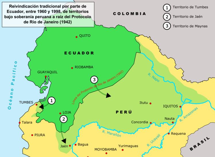
Maps published in Ecuador since the 1960s up to the end of the 20th century officially had to exclude the unmarked 78 kilometers of border, that is, the Rio Protocol line was drawn as unresolved, and to include what Ecuador considered as its own by right, according to the Pedemonte-Mosquera protocol (1830) line, which puts the Marañón (Amazon) river as the border between Peru and Ecuador.
Such controversial maps of Ecuador, known in Ecuador as "Tufiño's map", were referred in Peru as "mapa recortado del Peru" (cut-off map of Peru).
The Paquisha Incident (1981)
The Paquisha War was a brief military clash that took place between January and February 1981 between Ecuador and Peru over the control of three watchposts. While Peru felt that the matter had already been decided in the Ecuadorian-Peruvian War of 1941, Ecuador did not agree with the Rio de Janeiro Protocol. Later in 1998 the Guarantors of the Rio Protocol ruled that the border of the undelimited zone was indeed the line of the Cordillera del Cóndor, as Peru had been claiming since the 1940s.
In 1980, Peru invaded Paquisha border populations, Machinaza Mayaycu and nestled in the foothills of the Cordillera del Condor and Nangaritza valley, note that the President of Ecuador Jaime Roldos in person visited military outposts along the border. The previous sentence is incoherent. In the aftermath of the incident, both sides increased their military presence along the Cordillera del Cóndor area and Cenepa Valley, starting an escalating spiral of tension and provocation that finally resulted in another military confrontation in 1995, the Cenepa War.
The Cenepa War (1995)
The Cenepa War was a brief (January 26 – February 28, 1995) and localized military conflict between Ecuador and Peru, fought over control of a disputed area on the border between the two countries. The two nations had signed a border treaty following the Ecuadorian–Peruvian War of 1941, but Ecuador later disagreed with the treaty as it applied to the Cenepa and Paquisha areas, and in 1996 Ecuador declared the treaty null and void.
The indecisive outcome of the Cenepa War — both sides claimed victory — along with the mediation efforts of Argentina, Brazil, Chile and the United States, paved the way for the opening of diplomatic negotiations that ultimately led to the signing of a definitive peace agreement (the Brasilia Presidential Act) on 26 October 1998. The peace agreement was followed by the formal demarcation of the border on 13 May 1999 and the end of the multi-national MOMEP (Military Observer Mission for Ecuador and Peru) troop deployment on 17 June 1999 which effectively put an end to the longest territorial dispute in the Western Hemisphere.
1995–1998: Arbitration and final resolution
A cease fire was brokered by the four guarantor countries, and subsequently the Itamaraty Peace Declaration was signed on February 17, 1995. One of the declaration's clauses included the creation of the Military Observer Mission Ecuador-Peru (MOMEP) in order to verify ceasefire agreements, as well as observe and report infractions through diplomatic channels.
The MOMEP contingent was made up of observers, logistics, and aviation support from the United States, Argentina, Brazil, and Chile as part of Operation Safe Border. The mission, unique in its scope, was fully funded by Peru and Ecuador. MOMEP was largely successful despite several tragic accidents due to land mines left in the area.
At a critical moment during late July and early August 1998 it appeared that Peruvian forces were preparing a preemptive assault on Ecuadorian forces (this is partially believed due to the Peruvian airforce buying 19 Mig-29S and 18 Sukhoi-25 aircraft from Belarus to counter the abysmal state the airforce was in at the beginning of the conflict, with 80% of the fleet grounded due to lack of spare parts), but the presence of the MOMEP contingent was instrumental in defusing the situation. [21]
The guarantors assisted the parties in ministerial level discussions aimed at identifying the significant claims and disagreements of each side. Both countries agreed to a guarantor-sponsored technical commission composed of boundary experts in order to resolve the matter.
Before a critical meeting planned in Brazil for early 1997, both countries entered a period of unforeseen political events. In Peru, there was a hostage crisis in its Japanese embassy involving guerrillas of the Túpac Amaru Revolutionary Movement. Ecuador was going through a period of political instability as President Abdala Bucaram, a strong supporter of an agreement on the border issue, was removed by congress due to alleged mental incapacity. (President Bucaram, who is known for his unusual antics, had visited Peru and was seen on TV eating ceviche and wearing alpaca hoods—a traditional indigenous outfit—along with President Alberto Fujimori.)
These delays nevertheless gave the guarantors more time to come up with a solution to the dispute. Eventually they concluded that a resolution would not be possible without granting something to each party.
The commission recognized Ecuador's position on one small already demarcated section of the border, and Peru's position on the larger issue of the single watershed between the Zamora and Santiago rivers. The latter was a blow to Ecuador's historic position, and left Tiwintza in Peruvian territory.
The solution the commission arrived at was that an area of one square kilometer at the site of the fiercest fighting, Tiwintza, on the Peruvian side of the border, be granted to Ecuador as a non-sovereign private property. The site could be used by Ecuador to erect a monument and fly their flag. Even though neither country was completely satisfied with the solution, they both accepted it, which was a significant diplomatic success.
The resolution also called for the creation of two national parks contiguous to one another (also referred to as a binational park) in the Cordillera del Condor region.
Ambassador Luigi Einaudi, the US guarantor representative, is credited with coming up with the idea of a private property concession in Tiwintza, working almost full-time on the problem, and coming up with ways to express issues in a manner not offensive to either party. [22]
On October 26, 1998, these two nations signed a comprehensive peace accord establishing the framework for ending a border dispute. Formal demarcation of border regions started on May 13, 1999. The agreement was ratified without opposition by both nations' congress. U.S. President Bill Clinton said: "This signing marks the end of the last and longest running source of armed international conflict in the Western hemisphere".
Political, social and economic impact
This dispute is unique and significant in the study of causes and resolution of international conflict. Ecuador and Peru are populated by people who share a language, a culture, a religious preference, have basically the same social and ethnic diversity, and comparable economic difficulties. They are also both democracies (for the most part in modern times) which puts in doubt the common contention that democracies never go to war with each other.
Education and public perception
A 2000 study carried out as part of the educational ASA Program found teaching curriculum relating to the dispute to be extremely one-sided in both countries:
Many examples of bias are cited, which can typically be characterized as removal of critical information about the other side's position. Emotional and nationalistic coloring of the material also appears to be routine. Although expected under the circumstances, this has likely fed the cycle of conflict in the past.
Citizens of Ecuador and Peru feel both their countries have lost territory over time. The issue is one of overlapping maximalist territorial claims and aspirations.
Many Peruvians, for example, believe that their country is related with the Inca Empire, and that compared to the Tahuantinsuyo, is relatively small. At one point, the Viceroyalty of Peru contained most of South America. The Republic of Peru lost territorial claims to Bolivia (formerly known as Upper Peru), Brazil (Acre and other Amazon territory), Colombia (Leticia province) and Chile (Arica province and Tarapacá). Ecuadorians see their country as a continuation of what was the Real Audiencia de Quito, containing territories that are now parts of Peru and Colombia, reaching Brazil to the east.
High Peruvian military spending is seen by Ecuador as evidence of belligerence and expansionism. Peru also considers Ecuador belligerent and expansionist.
At the end of the 20th century things appear to have improved considerably. Ecuador's partial military success in the Cenepa War of 1995 allowed an honorable resolution of the conflict without a clear winner. To many Ecuadorians this was viewed as restoring the honor of the country, which was at least as important as their claims to the disputed territory. Unfortunately, not everyone is completely satisfied.
One example of this is the fact that in Peru there are still some who believe Ecuador shouldn't have been given perpetual private property rights over the single km² spot of land known as Tiwintza, which saw some of the most fierce fighting during the war of 1995. In time, more progressive views have found their way in the public discourse. More significantly perhaps, by the 1990s both nations had become exhausted by the endless dispute, and were more interested in finding a definitive negotiated solution to the border problem than ever before.
Today, the entire Ecuadorian-Peruvian border is clearly delimited and demarcated, and the maps of both countries agree on the location of the common frontier. Bilateral work is being done by both countries Foreign Affairs officers to consolidate the economic and social integration. We can see part of this done by the Peruvian government with their Consulate in Machala, El Oro, where Minister Efrain Saavedra is the Consul General.
Economic impact
One of the concerns both countries have had is the impact of the dispute on foreign investment. Thomas McLarty, US envoy at the resolution talks and former aid to President Bill Clinton, has said peace is essential to South America's economic recovery. He added: "You clearly cannot have long-term growth and prosperity involving foreign investment without stability". While there are still political instability issues in the region, resolution of the territorial conflict is helpful.
Trade between both countries has benefited considerably. Before signing the peace treaty, annual trade between Peru and Ecuador was about 100 million dollars. But as early as 1998, it had increased 5-fold.
There was also a broad agreement of integration between both countries. It included a binational fund for peace and development, national plans for productive, social and environmental development, and so on.
Political implications
According to Gabriel Marcella (US Department of National Security and Strategy), as a result of the Ecuadorian-Peruvian territorial dispute "a number of emerging views about international affairs, U.S. foreign policy, and modern inter-American affairs were either shattered or seriously challenged". Some of the global and regional political implications of the dispute which have been noted are the following: