
Existed: June, 1998 – present Length 13.5 km | North end: Atarot Junction Constructed June 1998 | |
 | ||
South end: HaMinharot Junction (u.c.) Major cities Jerusalem, Beit Safafa, Givat Mordechai, Givat Shaul, Beit Hanina, Atarot | ||
Highway 50, officially called Begin Boulevard (Hebrew: שדרות בגין, Sderot Begin) and also referred to as Menachem Begin Expressway or Begin Highway, is an urban freeway in western Jerusalem named after Israel's sixth Prime Minister, Menachem Begin. Local Jerusalemites simply refer to it as 'Begin' (pron. IPA 'bei-gin).
Contents
- Map of Begin Blvd Jerusalem
- Route
- History
- 5020
- Begin South
- Current Roadworks
- Future
- Interchanges South to North
- References
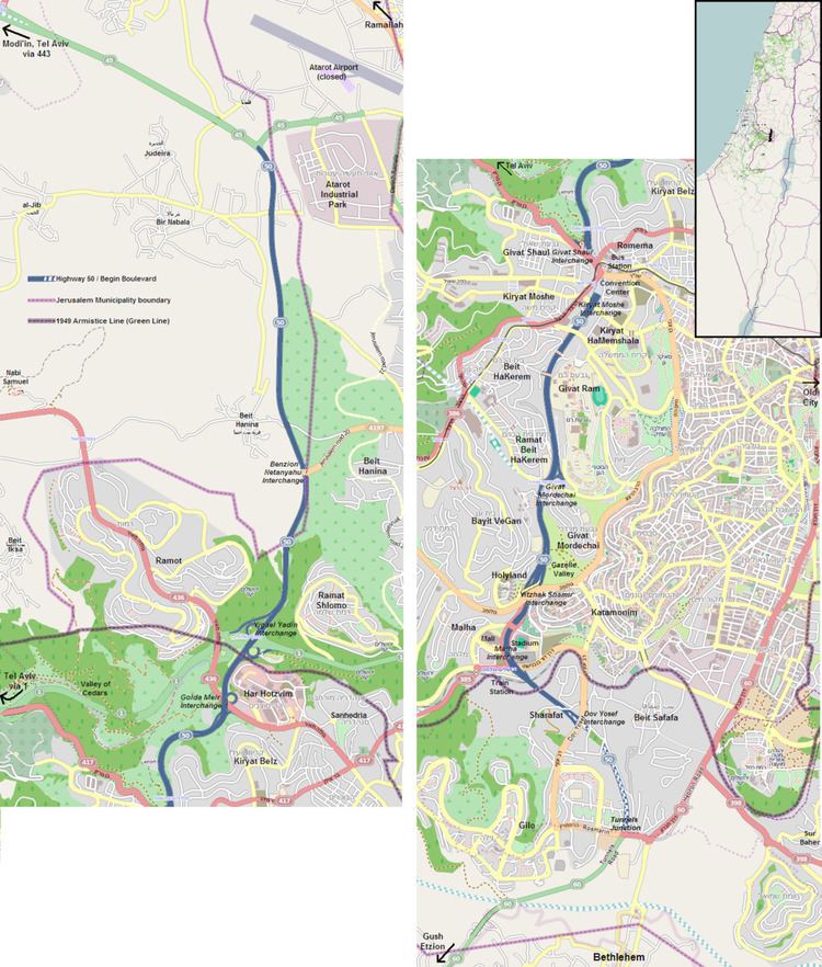
Map of Begin Blvd, Jerusalem
Route
The road follows a south-north path that connects key neighborhoods and commercial areas, as well as several city arteries and national routes. Beginning at the Tunnels Junction, the road travels North-west through Gilo and Malha to Golomb Junction, whence the road travels northward below the high ridge of the Holyland neighborhood to the west. To the east is Emek Hatzva'im (Gazelle Valley), a green zone which was previously leased to Kiryat Anavim and Ma'ale HaHamisha and used for agricultural purposes. Further on, the path was excavated to create a depressed roadway between Bayit Vegan, Givat Mordechai, Ramat Beit HaKerem & Givat Ram. This section is equipped with noise barriers and speed cameras.
The road then passes through two tunnels under Jaffa Road and the busy western entrance to Jerusalem. Winding down the western and northern slopes below Romema, the road steeply descends 150 meters into Emek HaArazim (Valley of Cedars) with interchanges at Golda Meir Blvd (Route 436) and Yigal Yadin Blvd (Highway 1). Passing between Ramot and Ramat Shlomo, the road continues through the west bank passing Beit Hanina, Bir Nabala and Atarot. Finally at Atarot Junction, Highway 50 officially becomes Highway 45 providing a continuous connection to Route 443 to Modi'in and the Tel Aviv area.
History
Begin Boulevard is made of the central section, which was completed two years ahead of schedule in June, 1998, and the northern extension completed in late 2002
Since its construction, the road was called national Route 404. In internal Jerusalem Municipality documentation, it was known as Jerusalem Road 4. In 2012, the Israel Ministry of Transport and the Jerusalem Municipality began using the designation 50. New blue "Highway 50" signs were posted by the National Roads Company of Israel to reflect this change. The Moriah-Jerusalem Development Corporation, responsible for road construction in Jerusalem also uses the designation, 50.
50/20
In the north, the "50/20 Interchange Project" was approved in 2010 along with the new Jerusalem Road 20 through Beit Hanina following AbdulHamid Shomaan St. and Hizma Rd. to Sayeret Duchifat Blvd. Construction was begun in 2011. This route alleviates heavy traffic at Sha'ar Mizrach Junction (Highway 1 and Route 60) by providing an alternative route via Begin to central Jerusalem and Route 443 to Tel Aviv for residents of Beit Hanina, Shuafat, Pisgat Ze'ev and Neve Ya'akov. The preliminarily named "50/20 Interchange" was officially opened on May 5, 2013 and renamed after Benzion Netanyahu, the Israeli historian and father of Benjamin Netanyahu.
Begin South
The "Begin South Project", first planned in 1990, involves widening Begin Boulevard from 4 to 6 lanes and extending it as a freeway past its current southern terminus to connect with Route 60 at the Tunnels Road in Gilo to Gush Etzion. Construction proceeded in stages beginning in 2010 to widen the highway between Givat Mordechai Interchange and Golomb Junction. At the same time, reconstruction of sewer lines further south was completed in order to accommodate the lowering of the highway to pass under Golomb Boulevard and local streets next to the Malha Mall, Teddy Stadium and the Jerusalem Malha Railway Station with interchange access to these locations. In 2013, a tunnel was built creating the new Golomb Interchange and work proceeded lowering the road past the Malha Mall and Teddy Stadium with service roads on either side. This first stage was completed at the end of 2014.
Further south, past the Malha Railway Station, the highway continues through the neighborhood of Sharafat with the completion of the second stage and the opening of Dov Yosef Interchange in March, 2015.
Current Roadworks
Construction continues on the final stage of the Begin South project between Dov Yosef Boulevard and Rosmarin Street. Through the neighborhood of Beit Safafa, despite the residents' objections and requests for a tunnel, the highway will continue as a slightly depressed roadway with a 200 meter wide, park-covered bridge at al-Qa'ash St. connecting the south-west corner of the neighborhood with its center. Ongoing litigation between the residents and the municipality regarding the proximity of the highway to houses and the desire for additional crossing points has, as yet, not been resolved. Construction of ramps to Rosmarin Street is expected to be completed by the Spring of 2016, while the full Rosmarin Interchange with tunnels is scheduled to be completed by September, 2017. The total cost for the project is expected to reach 1.1 B Shekels.
Future
In the center, a plan has been published to connect Begin Boulevard at Givat Mordechai Interchange to Highway 1 at the new Motza Interchange via the new Jerusalem Road 16. The road would travel mostly through a series of tunnels under the parking lots of Shaare Zedek Medical Center and the west Jerusalem neighborhhods of Yefeh Nof and Har Nof. In the center, the above ground Nahal Revida Interchange would lead to Givat Shaul. This would create another entrance to Jerusalem to ease the traffic congestion at the Ben Gurion Blvd./Jaffa Road entrance and provide direct access to south Jerusalem from the west. Expected to be completed by 2018, the plan still has to pass stiff resistance on ecological grounds due to the above ground section at Nahal Revida located in the Jerusalem Forest.