
Length 94 km | ||
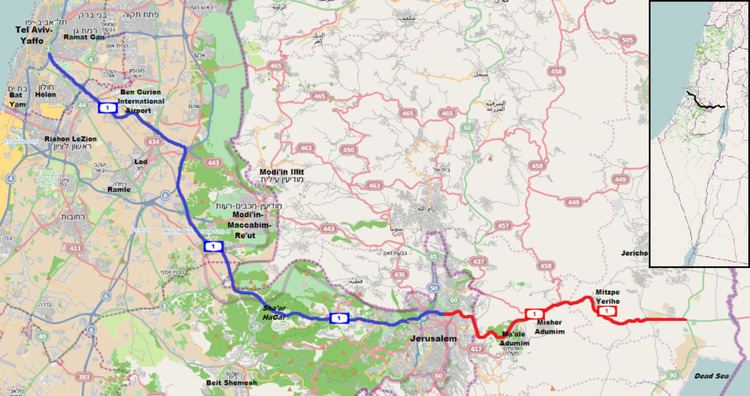 | ||
West end: Tel Aviv (Kibbutz Galuyot Interchange) East end: Jordan Valley (Beit HaArava Junction) Major cities Jerusalem, Mevaseret Zion, Rishon LeZion | ||
Highway 1 (Hebrew: כביש 1, Kvish Ahat), is the main highway connecting Tel Aviv and Jerusalem in Israel and continuing eastwards to the Jordan Valley.
Contents
The coastal plain and Judean foothills
The route begins as a six lane freeway as it splits off from the Ayalon Highway (Highway 20) just north of the Kibbutz Galuyot Interchange in Tel Aviv at an elevation of 16 meters above sea level travelling 0.7 km due south-southeast following the course of the Ayalon Stream. It then turns southeast, continuing past the 70 meter high Hiriya landfill, intersects Highway 4 and Route 412 and passes the Tel Aviv toll express lanes and park-and-ride facility. Israel Railways maintains tracks along the median of the highway along this section.
The road then makes an S-curve as it passes Ben Gurion International Airport and crosses north of the Ayalon Stream. Continuing south-southeast, the road intersects with Highway 40, the cutoff to Route 443 East and Highway 6 (Trans Israel Highway) North where it narrows to four lanes and rises to an elevation of 93 meters at Ben Shemen. Passing Ben Shemen, the highway descends slightly as it turns south-by-west, running concurrently for 1.5 km with Highway 6 providing access to Highway 6 South.
Leaving the Highway 6 concurrency, the road again turns south-southeast travelling through the Ayalon Valley where it intersects with Highway 431 just south of Modi'in. At this point, Israel's longest bridge, part of the Tel Aviv-Jerusalem High Speed Railway, can be seen in the valley to the north. The road crosses the Ayalon Stream and ascends to 250 meters as it briefly crosses the Green Line (the 1949 Armistice Line) for 1.5 km and back again at Latrun. The road then travels briefly alongside the Ilan Stream approaching Sha'ar HaGai (The Valley Gate) at 300 meters above sea level. At the Sha'ar HaGai Interchange, an Ottoman caravanserai is visible on the south side of the highway.
Ascent to Jerusalem
Passing through Sha'ar HaGai, Highway 1 begins a pronounced ascent through the Judean Mountains at a point between the Mishlatim Ridge to the north and the Shayarot Ridge and the famous Burma Road to the south. Along this section, abandoned rusted military vehicles have been preserved along the sides of the road to commemorate the efforts of the armored supply convoys which attempted to break through the siege of Jerusalem during Israel's War of Independence. Past Shoresh, the road reaches an elevation of 715 meters along the northern ridge of the Kisalon Valley at Kiryat Ye'arim (Telz-Stone). It then descends to 610 meters as it passes Abu Gosh while crossing the Kisalon Stream at Ein Hemed, and then again ascends reaching 730 meters as it passes Mount Ma'oz and Castel National Park at Mevaseret Zion. At this point, the road curves sharply and begins a steep descent offering breathtaking views leading to the dangerous Motza curve at an elevation of 560 meters where it crosses the Sorek Stream. The Yellin House Visitors Center, is concealed among the trees on the north side of the curve. Since 2013, the Sha'ar HaGai to Jerusalem section is being completely reconstructed and widened, with works set to be completed in 2017. These works also include eliminating the dangerous Motza curve.
Through Jerusalem
Now within the municipal limits of Jerusalem, the road turns northeast and begins the final ascent to the city. On the northern slopes below Har HaMenuchot the road splits at Sha'ar Moriah Interchange, completed in 2007. Before 2007, Highway 1 continued its ascent via Ben Gurion Boulevard negotiating three wide curves and three tight curves ending at the historic western entrance to the Jerusalem at the beginning of Jaffa Road. Since that time, the road as numbered now descends from the interchange into the Valley of Cedars (Emek HaArazim).
In the Valley of Cedars, the road also known as Jerusalem Road 9, passes through tunnels under a hill on the north side of the Sorek Stream. It then crosses the Green Line next to Ramot at an elevation of 630 meters as it intersects with Route 436 and Highway 50 (Begin Boulevard) at Yigael Yadin Interchange, becoming a four lane divided highway with traffic-light controlled junctions. Travelling due east, the road, also called Yigael Yadin Boulevard, passes Har Hotzvim and Ramat Shlomo ascending to its highest elevation of 815 meters as it intersects with the heavily congested Sha'ar Mizrach Junction (East Gate) at Shu'afat and French Hill. At this point the road crosses the tracks of the Jerusalem Light Rail and intersects with Highway 60 marking the watershed of the Judean Mountains.
Passing Sha'ar Mizrah, the road is called Derech Ma'ale Adumim. The greenery typical of the western side of the watershed is replaced by the eastern side's stark mountain-desert shades of beige. The road turns southward and begins descending, passing the Shu'afat refugee camp and the Al-Issawiya neighborhood. At this point, a new road alongside and separated from Highway 1 has been built which will become a connecting route between Ramallah and Bethlehem. Passing the At-Tur neighborhood, the highway leaves Jerusalem at the Zeitim Security Checkpoint. After this point, the road is open to green (Palestinian) license plates.
Jerusalem to the Jordan Valley
Turning eastward after the checkpoint, Highway 1 descends steeply to 375 meters as it passes Adumim Interchange with Route 417 providing access to Ma'ale Adumim, al-Eizariya and Abu Dis, joining the historic Jericho Road. The road turns east by northeast, continuing its descent passing E1 (Jerusalem), Mishor Adumim and Route 437 at 250 meters. Leveling out for the next 5 km and occasionally rising in elevation, the road passes the Nahal Og Nature Reserve (Wadi Mukhalik), intersects with the Allon Road (Route 458) and the famous Khan Al-Ahmar, a caravanserai associated with the New Testament story of the Good Samaritan.
Descending again the road briefly turns due south as it passes Mitzpe Yeriho. Turning southeast travellers have the opportunity to stop at a scenic overlook at Sea Level (0 meters) although the scenic view of the Jordan Valley at this precise point is mostly obstructed because of the surrounding mountains. The attraction for tourists is to be photographed in front of the sea level sign and for a price sitting atop a colorfully decorated camel. The road then turns eastward and descends below sea level passing the entrance road to Nabi Musa, a pilgrimage site where Muslims believe Moses is buried. At 230 meters below sea level, the road passes Jericho Junction, providing access to Vered Yeriho and Jericho. Passing Beit HaArava, Highway 1 ends at Beit HaArava Junction with Highway 90 at an elevation of 325 meters below sea level.
History
The section between Latrun and Jerusalem roughly follows an ancient path connecting Jaffa and Jerusalem. At the entrance to Jerusalem, the steep and winding rise was known as Ma'aleh HaRoma'im (Romans' Ascent) and covers a 3 kilometres (1.9 mi) path rising 200 metres (660 ft) in altitude. The Jaffa–Jerusalem road was initially made accessible for wheeled vehicles by the Ottomans in 1867 and since then served as the main highway to Jerusalem, favored over more topographically convenient routes such as Route 443. The largest bell for the church of the Augusta Victoria complex, built between 1907-10, weighed six tonnes and required that the road be widened and paved.
In 1948 the Latrun section of the highway was taken over by Jordan and traffic was diverted to a new route called "Derekh Ha'Gvura" (Road of Bravery), which is now part of Highways 44 and 38. In 1965 the old highway was widened to four lanes between Sha'ar HaGai and Jerusalem, and after the Six Day War the Latrun section was reopened and an interchange was built at Mevaseret Zion (Harel Interchange). During the 1970s a bypass was built around the village of Abu Ghosh, including the construction of Hemed Interchange.
In 1978 a new section opened, connecting former Road 10 (the Tel Aviv – Ben Gurion Airport road) with Sha'ar HaGai. The new section formed the third freeway in the country, after Highways 2 and 4. Although it is about 10 km longer than the old road (now Highway 44 and Route 424) it is much faster. One of the first passengers on this section was Egyptian President Anwar Sadat during his historic visit to Israel in 1977. This section briefly crosses over the Green Line near Latrun.
The section between Ganot Interchange and Ben Shemen Interchange was widened to six lanes in 1998. During the construction of Highway 6 (1999–2003), Ben Shemen Interchange was completely rebuilt, and a new interchange was built near the village of Kfar Daniel. Named for the adjacent village, the Daniel Interchange is actually a 1 1/2 kilometer straight, eight lane segment where Highways 1 and 6 run concurrently providing 1-west to 6-north and 1-east to 6-south high-speed interchange.
Motza Interchange opened in 1990 and Sha'ar HaGai Interchange opened in 1995. In 1998 the east bound left turn to Abu Ghosh, Ma'ale HaHamisha and Kiryat Anavim was closed. Finally, in 2002 Shoresh Interchange opened, eliminating the last left turn on the highway between Tel Aviv and Jerusalem. Although the Sha'ar HaGai - Jerusalem section is fully grade separated, the road does not meet freeway standards due to narrow shoulders, dangerous turns and difficult slopes, and the speed limit on this section is 80 km/h.
Anava Interchange opened on February 4, 2009 together with the eastern section of Route 431. It is a complex interchange and the first full freeway to freeway interchange in the country, connecting all eight directions between the two freeways without the use of traffic lights.
The section of the highway east of Jerusalem was first built by the British in the 1920s, also along the path of an ancient road to the Dead Sea. This section was under Jordanian control between 1948 and 1967, and renewed access to this road, which is known as the "Jericho Road" (Hebrew: דרך יריחו) or the Adummim Ascent (Hebrew: מעלה אדומים), was famously noted alongside the reunification of Jerusalem in the famous Israeli song, Jerusalem of Gold.
In the late 1980s, a new road was built north of Jericho Road, between French Hill neighborhood in northern Jerusalem and the town of Ma'ale Adummim. This section was improved by 1995, when it was widened and a new interchange was built at Ma'ale Adummim. A bypass of this section, designed to relieve congestion at Sha'ar Mizrah Junction, opened in 2002, connecting the highway through two 2-lane tunnels under Mount Scopus towards the Hebrew University, Bar-Ilan Street and central Jerusalem. As part of this project, the new HaZeitim interchange was built at the foot of the Mount of Olives.
The sections west and east of Jerusalem are linked by an expressway segment running north of the city centre. Known internally as Yigael Yadin road or 'Jerusalem Road 9', the stretch has divided lanes, but includes two at-grade intersections alongside its interchanges.
Derech Yitzhak Shamir
In 2001 Moriah, the Jerusalem Development Company, started building a bypass of the city's oft-congested western entrance, designated as 'Jerusalem Road 9'. Before it was built, travelers from west of Jerusalem who wished to reach the Dead Sea, or vice versa, had no better option than to drive through congested city streets. The road was intended to improve traffic flow in Ramot and nearby neighborhoods.
The 3.6 km road descends from the purpose-built Sha'ar Moriah Interchange to allow continuous separate grade access to Yigael Yadin Interchange and the northern and eastern continuation of Highway 1. Passing through Emek HaArazim (Valley of Cedars), it includes two 400 meter tunnels (one for eastbound traffic and one for westbound), four bridges over the Sorek stream and two new interchanges.
While the highway was scheduled for completion in early 2005, work was slowed to a near halt between 2003 and 2006 and completion was postponed for over two years. The opening, planned for May 21, 2007, was postponed another two months due to Moriah's failure to complete the required environmental mitigation. Permission to open the road was granted on condition that the company and Jerusalem municipality guarantee completion of environmental mitigation after the opening. Road 9 opened on July 25, 2007 and constitutes part of Highway 1.
In October, 2014, Jerusalem Road 9 was officially renamed "Derech Yitzhak Shamir" after Israel's 7th Prime Minister.
Development plans
The eastern section of the highway has been widened to four lanes between Ma'ale Adumim and Jericho. There are also plans to construct a continuous string of four-lane highways from Jerusalem to Amman, thereby shortening the one-way trip between these two cities to one hour. Route 1 would be a part of this string.
Israel Railways is building a new high-speed rail line between Tel Aviv and Jerusalem. This line will cross the highway at three points: over a viaduct east of Ben Gurion Airport, in a tunnel at Anava Interchange and in another tunnel at the western entrance to Jerusalem.
To relieve congestion at the entrance to Tel Aviv, an high-occupancy toll lane was built as a Build-Operate-Transfer project. The project includes additional lanes between Ben Gurion Airport and Kibutz Galuyot Interchange and a large park and ride facility east of Shapirim Interchange. Shapir Engineering started the construction of the park and ride facility in August 2007 and the project was scheduled for completion by December 2010.
Upgrading the mountainous section between Sha'ar HaGai and Jerusalem with additional lanes and gentler curves was approved by the Committee on National Projects after many years of opposition by ecological groups and local governmental authorities. Also according to this plan, the uni-directional Kiryat Ye'arim Interchange will be rebuilt to allow access to eastbound traffic, a tunnel will be built under the Castel Mountain (HarEl) with more efficient entry and exit ramps and a long bridge will be built to straighten the dangerous Motza curve. The soil extracted from the tunnel will be used to widen the Shoresh - Sha'ar HaGai section, raising the road by five meters to straighten the curves and widen the road from four to six lanes with wider shoulders.
Opposition on ecological grounds to the Sha'ar HaGai-Shoresh section which passes through a sensitive nature reserve has been addressed by the inclusion of a 70 meter wide eco-bridge as part of the plan. Additionally, the quality of life issues raised by the leaders of the nearby communities were all rejected. Work is expected to be completed by mid-2017, at a cost of over 2.5 billion NIS ($750 million US).
By February 2012 the National Roads Authority published requests for tender (invitation for bids) for the Sha'ar HaGai-Shoresh section and the HarEl Tunnel to be implemented as design–build projects. By January 2014 extensive infrastructure works were taking place along the entire project's route.
Jerusalem Road 16
Just as Jerusalem Road 9 provided traffic relief to motorists headed to northern and eastern Jerusalem by bypassing the main western entrance to the city, an additional project to alleviate the bottleneck in the western entrance consists of the construction of Jerusalem Road 16. This would create another entrance to Jerusalem and provide direct access to central and southern Jerusalem from the west. The planned road would connect Highway 1 at the new Motza Interchange to Jerusalem's Highway 50 (Begin Boulevard) at Givat Mordechai Interchange. The road would travel mostly through a series of tunnels under the west Jerusalem neighborhhoods of Har Nof and Yefeh Nof and the parking lots of Shaare Zedek Medical Center with an intermediate Nahal Revida Interchange leading to Givat Shaul. The project will cost approximately NIS 1.5 billion and is expected to be completed by the end of 2019. The plan still has to pass stiff resistance on ecological grounds due to the above ground section at Nahal Revida located in the Jerusalem Forest. The Israeli minister of transportation has announced that construction tenders for the road will be issued sometime in 2014.
Hazardous road
28.5 km of highway 1 had been declared as a red road by the Israeli police in 2015.