
 | ||
High Pavement is a street in Nottingham, England. It is one of the earliest streets in the city, and most of its buildings are listed.
Contents
- Map of High Pavement Nottingham NG1 UK
- Nottingham high pavement 3
- History
- North side west to east
- South side west to east
- References
Map of High Pavement, Nottingham NG1, UK
Nottingham high pavement 3
History
It runs from the east end of St. Mary's Churchyard to Weekday Cross. Around 1681 a row of houses was constructed on the south side of St. Mary's Churchyard. They existed until they were pulled down around 1792 when the street was widened. A new wall was constructed along the south side of the churchyard.
In 1799, the name of a portion of the street between Short Hill and St. Mary's Gate was called "St. Mary's Church Side". The name didn't take and was abandoned about 1815.
The Blue Coat School was located on High Pavement from 1723 to 1853.
In the Georgian era, High Pavement was one of the most fashionable places to live in Nottingham.
In 1819 a gas lamp was installed at the top of Drury Hill by the Nottingham Gas Light and Coke Company. Previous lighting had been by whale oil lamps.
On 8am 10 August 1864, the last public hanging was held. Richard Thomas Parker was hanged for the murder of his mother. He was buried in the precincts of the gaol by the side of Fenton and Saville.
15, 17 and 19 were demolished in 1931 to provide additional car parking for Shire Hall.
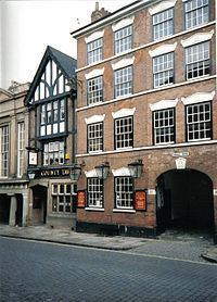
North side (west to east)
South side (west to east)
Joined at some point to No.56 High Pavement which it abuts. Possibly not a town house but erected specifically for commercial use in the lace or textile trade. There is machinery in the cellars and a hoist for the carriage of goods in the loft area with trapdoors evident below.
More recently used as Accountant's offices in conjunction with the No.56 building but internally many alterations have erased much of the interior including no sign of the original staircase. Whilst the loft area is broadly in a close to original state (with exposed reed walls, blue distemper surfaces and original floors) the other storeys have been remodelled and with only small areas of detail such as coving evident behind suspended ceilings. Repaired in recent years and now used as offices and a new media centre. Access to the rear is via a side gate which opens into a very small courtyard area which mainly serves the neighbouring buildings.
The front of No.54 has cellars carved from the sandstone which were used in part for the storage of coal; the architecture in this area only one floor below is curious in retaining evidence of a different layout to that currently including a redundant stone lintel. There are bricked up areas that appear not to have been recently explored but to the rear extensive work has taken place to create an additional office space with evidence of further unexplored spaces below.
Occupied after the First World War as a Public Assistance Office. Damaged in air raids in the Second World War, more recently used as Accountant's offices (Prior & Palmer, then Cooper Parry Prior & Palmer, latterly PKF Cooper Parry) and at some point joined with No. 54 High Pavement. Sold eventually for redevelopment and was in need of repair and refurbishment, now used as offices and a new media centre and the two buildings jointly renamed Lace Market House to reflect their location. .
It was erected by John Whitlock and William Reynolds in the 1650s. In 1808 Dr. Bristow sued the widow of the former vicar Nathan Haines for not keeping the vicarage in good repair. With the £70 proceeds, (equivalent to £4,923 in 2015), he remodelled the front and the interior. Current building is Mid C18, altered mid and late C19.
There is a simple cave system underneath comprising a passageway and bricked up alcoves leading to a chamber close to the cliff edge to the south. The chamber is fitted with brick built bins but mainly filled with building rubble which is likely to have arisen from the demolition some time ago of a property above, where now there is a car parking area.
Despite many internal alterations there is a good main staircase plus side stairs and various areas where original coving etc. remains. There are two good plaster relief ceiling roses in the main area and some Georgian wooden cupboards of note in a private office. A substantial rear extension comprising a meeting hall and upper rooms dating from Victorian times may have been used for parish council or ecclesiastical purposes and shows evidence to the rear of a separate entrance. The ground floor hall is used part-time now by a religious group which holds services on Wednesdays and Sundays.