
Location Nordland, Norway Highest point Hestmonkallen Municipalities Rødøy, Lurøy Area 13.6 km² | Highest elevation 571 m (1,873 ft) County Nordland Elevation 571 m | |
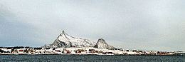 | ||
Hestmona or Hestmannøy is an island on the border of the municipalities of Rødøy and Lurøy in Nordland county, Norway. The island of Nesøya lies to the west, Lurøya lies to the south, and the mainland at Tonnes lies to the east.
Map of Hestmona, 8197 Storsels%C3%B8y, Norway
The northern and eastern parts of the 13.6-square-kilometre (5.3 sq mi) island are flat and marshy. The Arctic Circle crosses the northern part of the island. There are ferry connections to the surrounding islands and to the mainland at Jektvika. The 571-metre (1,873 ft) tall mountain Hestmonkallen is located in the southwest.
References
Hestmona Wikipedia(Text) CC BY-SA