
OS grid reference SE248677 Dialling code 01977 | Civil parish Hessle and Hill Top Sovereign state United Kingdom | |
 | ||
Region | ||
Hessle and Hill Top is a civil parish in the City of Wakefield in West Yorkshire, England. Until 1974 Hessle and Hill Top was part of Hemsworth Rural District but still retains Hemsworth as its UK parliament constituency. Hessle and Hill Tops recorded population is 138 people according to the 2011 census conducted by the office for national statistics.
Contents
Map of Hessle and Hill Top, UK
In the 1870s Hessle and Hill Top, previously known as Hasel, was described as
"a township in Wragby parish...4 miles E of Wakefield"Other surrounding places of notable interest include Ackworth, a larger neighbouring parish to the east, Fitzwillam, another small parish 1.25 miles (2 km) south-west of Hessle and Hill Top, which is also the closest railway station. Nostell, a smaller village to the west and is currently grouped with Hessle and Hill Top as well as several other small parishes as a division of Wakefield city council, and Pontefract, another large town to the north and a common reference frame for where the parish is located.
The Parish
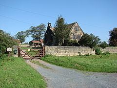
The earliest recorded date for the parish is 1066, referred to as Hessle, derived from haesle meaning hazel tree, under the administrative unit of Odgodcross and attributed to a Lord Alward in 1066 and then to Lord Mauger of Elington 20 years later. Hessle and Hill Top is a small parish largely consisting of green space and countryside, with the woodland and agricultural farm land making up roughly 95% of the total land use, however only 6.1% of the parish use these spaces. Within the parish there are 66 listed dwellings, none of which are the earliest recorded 9 households of the parish noted by the doomsday book, however there are 5 structures dating back to between 1641 and 1810, which are of grade II listed building status, preserving some of the parishs' history. The majority of households in the parish are 3 bedroom detached or semi detached properties which is due to the lack of demand for larger and more properties within the parish. Due to the parishs' small size there are almost no local shops within the parish, however there are many other neighbouring settlements which do provide such services, the closest of which being Ackworth. There are two walks scenic walks, which vary in length, that go through Hessle and Hill Top and the neighbouring parish of Ackworth, going past most of both parishes notable landmarks and places of interest.
Population
The population of Hessle and Hill Top has shown a decrease since 1881 from a total population of 296 to its current population of 138, according to the 2011 census, this can be seen as part of a steady trend since the beginning of the 20th century. The population structure of Hessle and Hill Top has an expected largely older population making the vast majority, with people aged 40 years old and over making up 73% of the total population of the parish. Other indicators of the ageing population of the parish include the mean age of the parish being 45.6 years old, 6 years older than the national average. The parish is an almost entirely white population with only 1 person being of mixed race and the other 137 being of white British descent, this division is unlike the rest of Yorkshire and the Humber as well as the rest of the country, which has a vastly greater mix of ethnicities.