
Official website www.herronisland.org | Population 152 (2000) Area 123 ha | |
 | ||
Herron island cabin tour 11 9 09
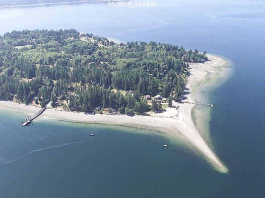
Herron Island is an island in central Case Inlet in the southern part of Puget Sound in the U.S. state of Washington. The Pierce County island has a land area of 1.2326 km² (304.57 acres) and a population of 152 persons as of the 2000 census.
Contents
- Herron island cabin tour 11 9 09
- Map of Herron Island Washington 98349 USA
- Herron island country store
- HistoryEdit
- 1792Edit
- 1841Edit
- 1950Edit
- References
Map of Herron Island, Washington 98349, USA
Herron Island is one of the few privately owned islands in Puget Sound. All access to the island is by boat, mostly aboard the HMC ferry, the "Charlie Wells", and a guest pass signed by an HMC member is necessary to board the ferry. The island is 1.25 miles (2.01 km) long, and 1/2 mile (800 m) across.
Corporate properties include the North Beach Park and small boat docks, the South Beach (undeveloped), roads and rights of way, Goodpastor Park and adjacent wetlands, Community Building and Fire Station, water system, ferry and ferry docks, as well as numerous greenbelt lots throughout the island. All other land is privately owned. Ownership of waterfront lots includes the tidelands down to the mean sea level.
Herron island country store
HistoryEdit
Herron Island was named by Charles Wilkes during the Wilkes Expedition of 1838-1842, to honor Lewis Herron, the expedition's cooper.
Herron Island is a completely private island. It was incorporated on April 30, 1958, as Herron Maintenance Co. (HMC), a non-profit, non-stock Washington corporation consisting of the owners and purchasers of property on Herron Island. HMC is governed by its ByLaws and administered by an unsalaried Board of Trustees elected annually from the membership. The Board is responsible for overseeing the operations and maintenance of the corporation's properties, and establishing a balanced budget to fund these operations. Herron Island is funded solely by annual and special assessments paid by the members and by the ferry fee.
1792Edit
Lieutenant Peter Puget, under the command of Captain George Vancouver, explored what is now known as Case Inlet in Puget Sound, in May, 1792. On the 23rd of May, the sailors didn't get underway until 8:00 AM, much later than usual, due to the very heavy fog in the area. Because a new group of Indians was encountered at the mouth of the Nisqually river, and Lt. Puget didn't know whether they were friendly or not, the ship delayed landing until 2:00 PM that afternoon. Just after the landing, another squall, with heavy rains and wind gusts, prevented them from proceeding any further that day.
The tiny island they landed upon was dubbed "Wednesday Island". It was actually Tuesday here, but the Vancouver expedition used "England time" throughout their explorations.
The ship's botanist, Archibald Menzies, whose job it was to explore every place they landed, refused to venture from the landing site to collect soil and botanical specimens, due to the heavy rain and wind.
1841Edit
In 1841, Lieutenant Charles Wilkes of the United States Navy, re-explored, re-charted (and frequently renamed) the islands of Puget Sound.
Large and important islands were renamed for his most important sailors. Smaller islands were renamed for his lesser sailors. Lt. Wilkes renamed Wednesday Island for Seaman Herron. Little is known about our namesake, except some rumors that we decline to believe. In any case, we salute Seaman Herron - we think he'd be proud of what we've done with his little island.
1950Edit
(The following was provided by Reed Skibeness, one of our mainland neighbors.)
My family started to come over to this area in the late 1940s or early 1950s. We have owned property on the west shore of the Longbranch Peninsula, across from Herron Island, since then. If one walked south from the ferry dock on Herron Island and looked east, we are situated on the shore across the water.
At the time we first started coming over there, there was a single old large building and an occupant on the north end of the island - - sort of a caretaker for the island. The owner (or caretaker) used a World War II LST for crossing the water between the island and where the ferry now docks on the east end of its run. The LST had a large front door that dropped forward onto the beach once the LST pushed itself onto the beach.
I don't know how long he lived on the island or even if he had a family living with him. All I know is that he was there and his LST frequently crossed the channel, I assume for supplies. At the time there were no roads on the island, but there were some trails heading south from the north end of the island.
Somewhere along the line the island was put up for sale. I don't know the details, but there was a period of time that passed prior to what could be considered your (or your HMC's) purchase. My father and my uncle seriously considered purchasing the island. I guess they considered it too expensive and dropped their plans for such a venture. Boy - - did they miss the boat!
As young teenagers my siblings and I had great times on our many trips to what seemed to us an abandoned island. We did a lot of roaming around on the island and even did some geoduck digging on the southeast shores. They were very plentiful, shallow, and easy pickings - - much easier to get than what we experience these days on the Longbranch Peninsula shore.