
County DeSoto Time zone Central (CST) (UTC-6) Elevation 116 m Population 15,000 (2013) Area code 662 | Established 1839 FIPS code 28-31780 Zip code 38632 Local time Friday 4:29 AM | |
 | ||
Weather 12°C, Wind NW at 13 km/h, 100% Humidity Area 66.82 km² (66.56 km² Land / 26 ha Water) | ||
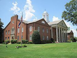
Hernando is a city in central DeSoto County, Mississippi, United States. The population was 14,090 at the 2010 census, up from 6,812 in 2000. Hernando is the county seat of DeSoto County, the second-most-populous county in the Memphis metropolitan area. U.S. Route 51 and the I-55 freeway traverse the city from north to south, and the I-69 freeway crosses the city from east to west. Hernando's historic downtown square, which surrounds the county courthouse, sits at the intersection of Commerce Street and U.S. 51.
Contents
Map of Hernando, MS, USA
History
Hernando is named for the Spanish explorer Hernando de Soto, discoverer of the Mississippi River.
Geography
Hernando is in the center of DeSoto County, bordered to the north by the city of Southaven. Via Interstate 55 or US 51, it is 25 miles (40 km) north to the center of Memphis, Tennessee, and south 15 miles (24 km) to Senatobia. According to the United States Census Bureau, the city of Hernando has a total area of 25.8 square miles (66.9 km2), of which 25.7 square miles (66.6 km2) is land, and 0.1 square miles (0.3 km2), or 0.39%, is water.
Climate
The climate in this area is characterized by hot, humid summers and generally mild to cool winters. According to the Köppen Climate Classification system, Hernando has a humid subtropical climate, abbreviated "Cfa" on climate maps.
Education
Hernando is served by the DeSoto County School District.
Demographics
As of the census of 2000, there were 6,812 people, 2,482 households, and 1,809 families residing in the city. The population density was 603.0 people per square mile (232.8/km²). There were 2,720 housing units at an average density of 240.8 per square mile (92.9/km²). The racial makeup of the city was 76.35% White, 21.48% African American, 0.15% Native American, 0.66% Asian, 0.78% from other races, and 0.59% from two or more races. Hispanic or Latino of any race were 3.04% of the population.
There were 2,482 households out of which 35.5% had children under the age of 18 living with them, 55.2% were married couples living together, 13.4% had a female householder with no husband present, and 27.1% were non-families. 22.9% of all households were made up of individuals and 8.5% had someone living alone who was 65 years of age or older. The average household size was 2.60 and the average family size was 3.05.
In the city, the population was spread out with 25.9% under the age of 18, 9.4% from 18 to 24, 30.9% from 25 to 44, 22.0% from 45 to 64, and 11.7% who were 65 years of age or older. The median age was 34 years. For every 100 females there were 98.8 males. For every 100 females age 18 and over, there were 97.5 males.
The median income for a household in the city was $43,217, and the median income for a family was $51,155. Males had a median income of $39,706 versus $25,685 for females. The per capita income for the city was $20,731. About 6.5% of families and 9.8% of the population were below the poverty line, including 12.2% of those under age 18 and 16.3% of those age 65 or over.