Puneet Varma (Editor)

Hermigua

Updated on
Edit
Like
Comment
Share on FacebookTweet on TwitterShare on LinkedInShare on Reddit
Country
  
Spain

Island
  
La Gomera

Area
  
39.67 km²

Population
  
1,919 (2014)

Autonomous community
  
Canary Islands

Elevation
  
210 m (690 ft)

Local time
  
Friday 9:29 AM

Hermigua wwwspaininfoexportsitesspaininfocomuncarrus

Weather
  
28°C, Wind E at 11 km/h, 27% Humidity

Province
  
Province of Santa Cruz de Tenerife

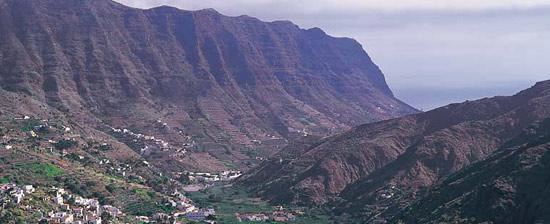
Hermigua is a town and a municipality in the northeastern part of La Gomera in the province of Santa Cruz de Tenerife of the Canary Islands, Spain. It is located 12 km northwest of the island's capital, San Sebastián de la Gomera. The Garajonay National Park covers the southern part of the municipality.

Contents

Map of Hermigua, Santa Cruz de Tenerife, Spain

There are cedar forests in the area known as El Cedro. The valley was first inhabited by the Guanches and was known as Mulagua. The municipality of Hermigua was founded in the 16th century as the settlement of Valle Bajo.

Settlements

  • Valle Bajo divides the settlements of El Curato and El Palmerejo
  • Valle Alto divides the settlements of La Castellana and Playa Hermigua
  • El Cabo
  • Monteforte
  • Los Estanquillos
  • El Corralete
  • El Convento
  • La Cerca
  • Las Hoyetas
  • Caserío del Cedro
  • Sites of interest

  • Valle Alto, the first settlement in Hermigua: its neighbourhood "El Convento" features a Dominican church and monastery built 1611; another landmark is the Escuela popular
  • El Chorro waterfall
  • Los Telares Museum: contains handicrafts from the surrounding area
  • "Roques Pedro y Petra"
  • "El Curato"
  • "El Pescante" (The Old Davit)
  • "El Caserío del Cedro": a hamlet by the National Park in a small isolated valley
  • "Playa de La Caleta" (La Caleta Beach)
  • "Ermita de San Juan"
  • Mahona Natural Reserve
  • References

    Hermigua Wikipedia